Small surf for the short term; next weekend looks dynamic

Sydney, Hunter and Illawarra Surf Forecast by Ben Matson (issued Friday 19th January)
Best Days: No great days due to a lack of size. Though most mornings should see light winds, and Sat should have some small leftover S/SE swell at exposed beaches, best suited to the Hunter coast.
Recap: Thursday saw solid waves early thanks to the reinforcing long period energy that arrived later Wednesday, though size eased during the day. South facing beaches were in the 6ft range with bigger sets across the Hunter, but wave heights were smaller south from the Illawarra and at beaches with less southerly exposure. Conditions were clean with light offshore winds ahead of an afternoon sea breezes. Size eased further today from 3-4ft at exposed beaches, now smaller. Early light N’ly winds are freshening from the NE.
Today’s Forecaster Notes are brought to you by Rip Curl
This weekend (Jan 20th - 21st)
After a rather significant week of waves, we’re looking at small residual energy for the weekend.
Wave heights will continue to abate into Saturday, so don’t expect much more than a lazy 1-2ft at most open beaches, perhaps a few bigger sets across the Hunter region. Early light variable winds will trend around to the NE throughout the day but no major strength is expected.
On Sunday, we’ll see a temporary dip in size early morning, but a minor E’ly pulse is due throughout the day from the southern flank of the remnants of this week’s Tasman Low - which is weakening just north of our swell window, but will momentarily restrengthen early Saturday. We won’t see much more than 1-2ft at most open beaches but it should provide some small waves into the afternoon.
However, winds will be freshening more vigorously from the north-east by the time this swell starts to appear properly, so don’t expect a lot of quality after lunch. Keep your expectations low and be pleasantly surprised if it comes in earlier for the morning session.
Next week (Jan 22nd onwards)
At this stage, a stationary high pressure ridge south of the southern states and a trough over the inland region is expected to maintain N/NE winds for most of next week. We’ll see small pulses of local windswell ebb and flow throughout this period though no great size (or quality) is expected.
Otherwise, we’re not expecting much surf from anywhere else throughout the week. So, it’s going to small and average for some time.
Fortunately, we still have a few systems on the long range charts that are offering potential.
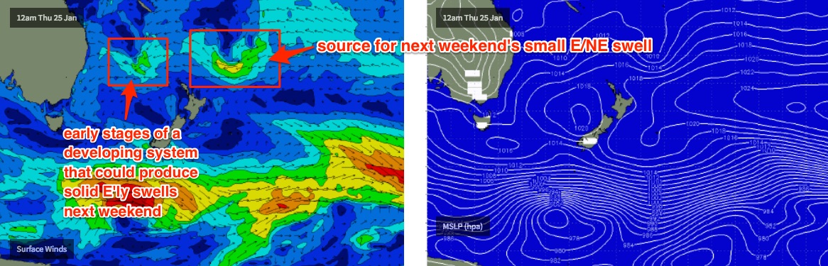
The broad tropical low developing east of Fiji this weekend is still expected to move slowly south, then south-west into our swell window. But at the moment, it reaches maturity just NE of New Zealand later Tuesday or Wednesday, with just enough strength to generate some small inconsistent lines for our coast next weekend, perhaps 2-3ft. Let’s take a closer look on Monday.
Also, the models have been to-ing and fro-ing with regards to a possible Coral Sea trough or cyclone over the last few days, and it’s still certainly on the cards. At this stage the most likely development (for favourable swell prospects) seems to be slated later next week in the Northern Tasman, which suggests a possibly strong E’ly swell next weekend, holding into the first part of the following week.
But, this is all still some time away so let’s hold back on the froth factor for now.
See you Monday!
Comments
gday ben
in wednesdays notes you mentioned a small flush of south swell mid week, is this still on? i can see some .3 or .4 at 14 or so seconds on our chart, worth working around?
Hope this east swell comes... Sandbanks a my closest beach and a little further have been wiped clean.
Disappointing waves today with beautiful conditions. Was more like trying to ride a piece of flubber than a wave.