Large period of S/SE swells, biggest Wednesday, best Thursday

Sydney, Hunter and Illawarra Surf Forecast by Ben Matson (issued Monday 15th January)
Best Days: Tues/Wed: v.large S/SE swell combo though confined to protected southern corners thanks to gusty S'ly winds. Thurs: large though easing S/SE swell with light variable winds and sea breezes. Fri: early light winds, moderating S/SE swell.
Recap: Saturday delivered some tidy waves, with a peaky combo of SE and NE swells providing 3ft sets at most beaches. Winds were variable tending offshore throughout the day ahead of a late S’ly change that dominated Sunday, building windswells across the coast but limiting surfable options due to the wind strength. This morning saw a temporary abatement in wave heights to 3-5ft at south facing beaches, however we’re looking at increasing surf over the coming days as a Tasman Low develops to our east.
Today’s Forecaster Notes are brought to you by Rip Curl
This week (Jan 16th - 19th)
The weekend’s model updates delivered more about-faces than I’ve seen in quite some time. Every twelve hours veered between large or tiny, so it’s been really hard to get a grip on the broader trend.
But now we’re very close to the genesis off this impressive system, we can have more confidence in how it’s going to play out.
Right now a Tasman Low is developing in the Central Tasman Sea, poorly aligned for the East Coast but with a broad, long fetch activating (indeed, ‘priming’) the western half of the basin.
A Southern Ocean front is also entering the lower Tasman Sea and is expected to merge with the Tasman Low overnight and into Tuesday. This will broaden and super-charge the system, with core winds expected to reach 40-50kts. This will be working on top of the active sea state generated by today's winds.
In general, most of the core fetch will be aimed into the Coral Sea - somewhat perpendicular to the East Coast, and outside of our swell window - however the main feature of note is that the broader Tasman Low will remain very slow moving for a few days. This will anchor a broad belt of southerly winds in our swell window (down to about northern Tasmanian latitudes) and their extended period of activity in the same location will allow the swell to really develop some size and muscle.
On the balance, this factor leads towards a slight upgrade in size for this swell event (as well as moving the timing around since Friday's notes were issued), however this upgrade is more relevant for Northern NSW due to the latitude of the fetch and its alignment. As such, I’m a little cautious for the projected size across Southern NSW - we’re certainly looking at some large waves across the Hunter region, and probably parts of the Sydney coast but south from Wollongong surf size will start to tail off as we move further anti-clockwise around the arc of angular spread.
Overall, the broad trend from Tuesday through Thursday is for large swells that’ll pulse intermittently in the 6-8ft range at south facing beaches. Maximum size is expected Wednesday when some locations from Sydney to the Hunter region could be looking at larger surf (i.e. 8-10ft) though I am expecting slightly smaller surf south from the Illawarra. Surf size will then slowly easing from Thursday, though the morning should still have a considerable percentage of Wednesday’s size.
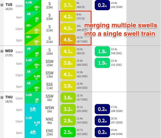 As per usual, expect smaller surf at beaches that have less southerly exposure. Also, please note that our computer generated model graphs have Tuesday being more sizeable than Wednesday. This is most likely because Tuesday is combining all of the swell trains into one, where as Wednesday morning splits them out into two trains (see chart to the right). It’s only a small point in difference but I do think we’re likely to see slightly larger waves on Wednesday.
As for conditions: Tuesday and Wednesday will be accompanied by fresh to strong S’ly winds, which will add a reasonable percentage of short range windswell to the mix (see note above re: single swell train) and also confine the only workable options to protected southern ends and point breaks. Early morning should see brief, isolated regions of SW winds (mainly across the usual suspects i.e. Northern Beaches).
Thursday is by far the best day of the forecast period, with large easing S/SE swells and light variable winds tend offshor (ahead of an a'noon sea breeze) as a high pressure ridge moves across the coast. Early morning should still see the odd 6-8ft set at south facing beaches between Sydney and the Hunter, but it’ll be down to 4-6ft by the afternoon. Expect smaller surf elsewhere, and south from the Illawarra.
Friday is looking equally favourable with light morning winds and easing S/SE swell from 3-5ft to 2-3ft at south facing beaches between Sydney and the Hunter (again, smaller elsewhere and south of the Illawarra). Aim for an early surf as freshening NE winds are expected into the afternoon.
So, there’s no shortage of size this week in a synoptic environment that feels more like June than January.
This week (Jan 20th - 21st)
Make the most of the week, as it looks like the ocean will have exhausted itself by the weekend.
Current expectations are for tricky winds both days under an unstable troughy pattern (possible N’ly north from Sydney, but SE south of the Illawarra), and small residual swells around a foot or two at exposed beaches tops.
We may see a small lift in mid-range SE swell from the bottom of the trough but it’s far from a sure bet at this stage.
Next week (Jan 22nd onwards)
Nothing major on the long term charts, of any confidence anyway.
The super extended long range charts have some fruity expectations of a Coral Sea cyclone developing mid-next week and it making an attractive southward track into our NE swell window, but at such long range it’s pure fantasy. However, it can’t be ruled out at this time of the year so let’s dial in Wednesday to see what’s happening.
Comments
Swell kicked strongly mid-morning, 6ft close-outs at North Steyne..
Size considerably smaller in illawarra (although much more defined and groomed lines of swell).
Still expecting it to get bigger than yesterday during the day today Ben?
What do you mean by 'considerably smaller'? Do you mean relative to Sydney, or relative to yesterday? Pt Kembla buoy is pretty strong this morning.
As for the trend re: y'day/today - hard to tell (and still a little early to make a conclusive remark) but perhaps I was over estimating the secondary swell source from the bottom of the fetch. Always difficult in these kinds of situation where there are multiple swell sources in the mix.
One of the problems in verifying surf size trends via wave buoy data is that the buoys don't split out the swells into individual trains. So, we don't know if yesterday's windswell loading was a small or large amount (we can only guesstimate, based on the strength of the nearest coastal weather station).
But seeing North Head was 20-30kts S'ly yesterday, and is currently light W/SW, you'd have to say it'd be a contributing factor to the heights recorded at the buoy (i.e. has no relevance for a trend in underlying groundswell levels).
Cheers Ben, meaning relative to yesterday.
And I am going off eyes on the ocean - not the buoys (although can see they have taken a pretty big dip)
Yesterday morning around same time Barrack Point had legit 10ft sets - this morning its more like 5-6ft.
Thanks mate - that's great info. Kinda suggests I overestimated the influence of the secondary fetch (or, buggered up the timing, thinking the models had it the wrong way around). However it's still early to make a definitive call I reckon. Could easily see another pulse push through today.
Sweet Ben. Going to wait for this tide to drop out a bit, see if new pulse comes thru. Wind has just swung more S than SW down here but hopefully it abates a bit this arvo. Still options around down here in this wind unlike most of SYD tho so am sure will find something. Looking forward to tomorrow! Always looked like best window. Hope you're getting a few somewhere.
opposite situation in the eastern beaches -- bronte looks bigger today than yesterday. then again, things always look bigger when you have a board under your arm and are trying to work out how to get out, not just driving around having a squizzy taylor.
there is certainly a second, longer-period fetch in the mix.
Standing on the edge of Bronte pool for 45 mins with your brain going "go now, dont go, go now, dont go....."
I suggest legging it up to the cementary and paddling out from over there, a longer paddle but much safer. Just dont cut inside the bombie under cliffs!!
Don't give up on the secondary swell from the bottom of the fetch just yet Ben. I'm still thinking Friday could be pretty fun, with lulls.
That could be because I'll be off on Friday.
Some long period swell was performing its tricks on certain swell magnets yesterday?