Punchy NE weekend swell with a favourable window early Sunday; lots of swell for next week

Sydney, Hunter and Illawarra Surf Forecast by Ben Matson (issued Friday 1st December)
Best Days: Sun: early offshores and a punchy NE swell, easing quickly ahead of a S'ly change. Tues: possible window of OK winds in the a'noon. Wed: decent peaky swell combo with good winds. Thurs/Fri: good winds and a quality mix of swells from the S and E/NE.
Recap: Small residual E/NE swells on Thursday built from the NE overnight, with 3ft sets across NE facing beaches this morning and bigger waves due this afternoon. Winds are however freshening from the NE so conditions are bumpy.
This weekend (Dec 2nd - 3rd)
No real changes to the weekend forecast - strong NE swells Saturday but wind affected, with punchy but easing NE swells Sunday and an early wind shift to the NW.
However, this offshore change will be associated with a trough crossing the coast, and there’s been a tweak in the outlook for the afternoon. That is: a deep surface low will form east of Tasmania during the morning, driving strong S’ly winds across the region (mid-morning across the South Coast, into Sydney region early-mid afternoon).
This means the available window of clean conditions will be limited to early Sunday morning, with a shorter duration across southern locations and a longer duration across Sydney and Hunter coasts.
As for size, Saturday should fluctuate somewhere in the 4ft to maybe 4-5ft range at NE facing beaches, with smaller surf at south facing beaches and across the northern Hunter. Sunday morning should see a similar size range (3-5ft NE facing beaches around dawn) through it’ll trend down steadily during the morning, and further into the afternoon.
At this stage the low is expected to develop too late to provide a meaningful increase in new south swell across Sydney and Hunter coasts before the sun goes down (though, fresh S’ly winds would eat into the quality anyway). However we should see a solid late kick across the Far South and South Coasts up to 4-5ft from mid-afternoon onwards.
Next week (Dec 4th onwards)
The low forming east of Tasmania on Sunday is expected to slip to the south-east overnight. Whilst it’ll display a healthy southerly fetch about its western flank, its SE track will cap surf size around the 4-5ft mark at south facing beaches on Monday.
The NE swell will ease right back at the same time, through we should see a small undercurrent of persistent E/NE trade swell at remaining beaches through the early part of the new week.
At the same time, the weekend’s surface trough will linger about Northern NSW and will thus drive fresh SE winds about Southern NSW. So, surf quality won’t be great on Monday. These winds will also contribute some small SE windswell to the mix.
From here on the outlook gets very complex.
The lingering North Coast surface trough will receive a moisture injection from the tropics, and a southward shift plus an intensification will strengthen NE winds through our immediate swell window into Tuesday (though, with the axis of the trough right on the coast, we may see gusty SE winds locally for a period of time).
It does looks like the NE fetch will track a little too fast to the south to generate any major size, but there’s also a positive aspect to this - that is, the return westerly flow from the backside of the trough will kick in just after we see a (brief) peak in NE swell, sometime very late Tuesday or early Wednesday.
So right now Tuesday morning looks like it’ll remain onshore with a solid mix of S, SE plus some background E/NE swell. Tuesday afternoon will see these swells ease and a new short range NE swell build, and there’s a possible window for winds to back off and swing to the SW (confidence is low on this right now).
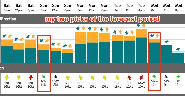
Wednesday morning is however the pick of the forecast period with 3-4ft to maybe 3-5ft if we're lucky out of the NE, and a light offshore breeze. However this swell will probably halve in size throughout the day. Let’s hope it doesn’t peak too early (i.e. Tuesday evening, under the cover of darkness).
Now, this forecast period (Mon thru’ Wed) will consist of swells generated in the Tasman Sea. Whilst this is all going on, other parts of our swell window will remain active:
1. The trough responsible for the Mon S’ly swell will linger across the Southern Tasman Sea, generating a small S/SE swell for mid-week.
2. A pair of E’ly dips north of New Zealand will for a broad E’ly fetch, and will generate some very useful E/NE swell for Southern NSW, due to persist across our coast from Wed thru’ Fri around 3-4ft.
3. The Tues/Wed deepening trough (just off the coast) will probably evolve into a new Tasman Low east of Bass Strait on Wed/Thurs, generating a fresh S’ly swell for Thurs/Fri. Size is difficult to ascertain right now though.
4. A small TC is possible around the Solomons mid-late next week, though at this stage it’s unlikely to be a swell producer for us.
So, did ya get all of that?
Short version: stacks of swell potential for the long term, from every angle of our swell window.
Have a great weekend! See you Monday.
Comments
I still can’t completely abandon the notion that surf forecasters are the great Satan, but I’m now resolved to the reality that ‘you can’t stop progress’, and that you have to be the greatest of the Satans.
I get a wry smile from kooks who think that two clicks and a graph on buoyweather (or equivalent) will resolve the complexities with the skill that you do.
Thanks mate - haven't had a quite a compliment like "Greatest of the Satans" before.
Think I'll put that one up on the pinboard.
Radical forcast for early December with so many different directions sounds dynamic
until you read the fine print 4 to 5ft but I will take it anyway. happy days
New rock bank
The Greatest Satan’s
Matson the lead percussionist
Shark Island lefts are looking pretty chunky this morning.
So so so cold....
It's summer. I can't wear a steamer on principle. Great waves this morning but I only lasted an hour in a springy, the last half of it in a semi-hypothermic state with no co-ordination and a long way from comfort.
That's what you get for going surfing in the middle of the night.
Are you nocturnal , Stu ?
First person in the water is my pet event.
I'm all for that myself.
Contingent to the Punxsutawney Phil Co efficient of course .
That being ill wake up pre dawn most days but upon putting a foot outside of the doona if the temperature is not equal to or greater than the temperature under the blankets then the early is postponed till after a leisurely breakfast.
As a consequence my dawnies are usually restricted to a few degrees either side of the equator.
7/10 on the Wollongong report. Hahaha. Written last night?
Is that too high or too low?
I had a session in the Illawarra that I would've squared away as 7/10. Next beach down looked a touch better, though I didn't see it front on, and I could imagine that given the conditions a few places to the north would've been unreal. Rising tide wouldn't have helped the beachies though.
id say its about right. tide was messing with alot of places and the wind went onshore for about an hour around 9 but there was plenty of waves around town this morning. still is actually. gonna hit it again!
Set wave out the back on the Island surfcam grab ain't especially small. Nice and clean too.
Smaller in Newy due to the swell direction, though some lovely sidewinders.
Gimme some of this!
There were plenty along the merewether bar beach stretch too
Checked from 6.30am and nothing punchy in the swell at all or anything around 4-5ft . lucky if it was headhigh at curly or manly. Direction better other spots looking at shark island etc. hope this week delivers punch and size.