Best day of the period shunted to Monday

Sydney, Hunter and Illawarra Surf Forecast by Ben Matson (issued Friday 6th October)
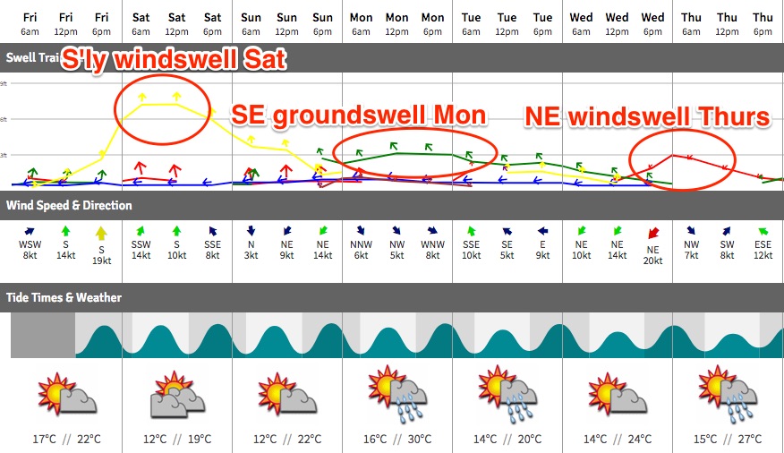
Best Days: Sat: large S/SE swell, though a little wind affected in the morning, improving into the afternoon. Sun: clean early with small leftovers from the S/SE. Mon: fun SE swell with morning offshores. Thurs: peaky NE swell with morning offshores.
Recap: It was a little frustrating to see only small south swell across most Sydney beaches through Tues/Wed - to which I correspondingly reduced south swell potential for Thursday and Friday - to then (after the forecast was published) receive confirmation via the Forecaster Notes comments that Tuesday’s south swell did in fact push above 3ft (as expected) at a few select south swell magnets down south (thanks Stu2d2!). Anyway, enough grizzling from my end. The last few days have seen a small mix of NE and S’ly swells, no more than about 2ft at open beaches but conditions have been clean through the mornings with light offshore winds. Winds are now moderate S/SE about the coast as a Tasman Low develops east of Tasmania.
This weekend (Oct 7 - Oct 8)
Whoa! There’s been some significant revisions in the model guidance since Wednesday, which has dramatically altered the outlook for Sunday. Saturday still looks to be on track as per previous expectations though.
S’ly gales developed east of Tasmania this morning (confirmed nicely by satellite data), and this system will push up through our short range swell window overnight. Surf size will peak early Saturday morning and trend down throughout the afternoon; we should see early 5-6ft sets at south facing beaches, with smaller 3ft+ surf elsewhere and very small surf inside protected southern corners. Bigger bombs are possible through the Hunter.
Fortunately, the model guidance - whilst weakening Sunday’s surf potential - has also eased up the strength of Saturday’s winds, which is an improvement for local conditions. They’re likely to be moderate to maybe fresh S’ly for a short period of time (may be SW for a brief period around dawn at a few select locations) but will rapidly abate into the afternoon, to become light and variable by the end of the day.
As such, wave heights will decrease but conditions will improve all day. It won’t be perfect but there’ll be some fun lumpy waves around.
The S/SE gales that were expected to develop across the southern flank of the Tasman Low tonight have been delayed, and also pushed further east towards New Zealand. And, reduced in strength too. These three factors have delayed and downgraded the expected SE groundswell for Sunday; we’re now looking at a Monday arrival.
This means Sunday will largely consist of easing leftovers from Saturday. Early light N/NW winds will keep conditions clean ahead of freshening N’ly tending NE winds throughout the day. We may see a small pulse mid-late afternoon from the SE but in general we’re looking at early 3ft sets at south facing beaches (much smaller elsewhere, but a little bigger in the Hunter), easing throughout the day ahead of the possible mid-afternoon pulse (probably back up into the 3ft range for the late session).
Aim for an early surf for the best waves.
Next week (Oct 9 onwards)
Monday should see the final pulse of SE swell from this Tasman Low. It’s expected to arrive in the morning and should produce 3-4ft waves at most beaches with a reasonable degree of southerly exposure, though we won’t see quite the same size differential between exposed and protected coasts as per Saturday’s south swell. Our surf model is undercalling this swell (building to 2-3ft), but apart a reasonable degree of inconsistentcy, I reckon we'll see some fun waves about Southern NSW.
There may also be some small NE windswell in the mix, but on the whole conditions will be clean with moderate NW winds in the morning, ahead of possible afternoon sea breezes.
Monday’s swell will ease rapidly through Tuesday, and a shallow S’ly change in the early hours of the morning is unlikely to generate any new swell. So, expect mediocre conditions and small, easing swells from the SE.
Nothing great is expected Wednesday with continuing small swells and freshening NE winds as a strong weather system approaches from the west. This will kick up a late NE wind wave for exposed beaches, but Thursday morning is currently the best time to capitalise on it as we’ll see winds swinging NW in the wake of the passing front (to the south). NE facing beaches should see fun 2-3ft sets, and it’ll be clean on top.
Long term model guidance suggests a fresh series of S’ly swells for next weekend, but it’s still early days. I’ll have more on that on Monday.
Have a great weekend!
Comments
3m of groundswell in winter = 4 - 5 ft south corner of manly and much bigger at south facing ends however these last few swells today and last week even queenscliff has only gotten around 3ft? This morning was a clean but slow 3ft peaky S swell resulting in closeouts a lot of waves and not much energy. Hopefully with more east in it sunday morning will be better? maybe 3 - 4 ft? The 1.7m NE swell 2 weeks ago and the 1.5m S swell were way bigger and resulted in great surf
Tasman lows don't produce 'groundswells for the south coast of nsw . A 1.6m plus swell with a period of 8, 10 or even 12 sec is not a groundswell. It is crap. They look nice from the south due to smoother bathymetric transition close to shore but it's always the same, everyone running around all day looking for a spot which isn't closing out or snipping off. Also for high quality waves what is required is clean energy, This means NO other wave energy or artefacts on or in the water. So it's actually bad to have a number of swells acting. When we have a clean swell from say the Ross Sea any little bit of other swell eg East windswell will ruin it or drastically reduce the wave quality. Sometimes we see on here that there is a groundswell forecast but even better we have another 2 swell sources present. That's nonsense boys. Chances are that if the system producing swell is directly influencing our atmospheric weather then it's local and can't produce decent surf. We don't get groundswell from the bass straight nor the south tip of New Zealand . There's another reference to groundswell in the comment above, a 3m groundswell in Sydney. At that amplitude it would have to have a Hugh period well above 20 sec and taking into account shoaling and refraction it could produce waves over 8m high. I saw barrels near my place in 1992 in a swell like that which were about 8 m high with about 2 m thick lip throttling way out square. We very rarely get a 3m groundswell on the east coast. I've only seen a few and I've seen em all.
"Tasman lows don't produce groundswells for South Coast of NSW"... eh?
Almost everything you've written is incorrect in some way shape or form - where your evidence, other than "I've seen em all"?
Great options across the coast this morning. Manly stretch looking super fun.
Well Sat showed potential @ only one point break here on the Lower/MidNth Coast which was insanely crowded for the relative quality of the swell. Bailed to the Cenny coast for a Sunday session @ a reliable reef that produced 4ft + set waves with only 6 to 8 surfers in the line up. The late arvo saw a renewal in sou/east swell with favourable winds so all in all it was worth the drive! I'm over the w/end crowds descending on the Lower/ Mid /Nth Coast! Better waves elsewhere but they turn up every W/end anyway not realising that these south swells are restricted to only one or two setups which are reliable but increasingly crowded by blowins!
Hahaha you taking the piss Groovie?
There's too much irony in your comments. The first being that you're upset by the crowds on the Mid North Coast by 'blowins' yet you went to the Cenny Coast to surf there.....as a blow in!? Haha!
Then the limited options at the local in Sth swells and them being too crowded......maybe you should reconsider your spruking of scoring these waves online before you're even out of your wetsuit. You are 100% feeding your own problem by shitting in your own nest.
Groove fm surf reports. God speed!!
Whilst the blow in festered 4ft waves meanwhile squid bEd was “pumping “
Never name any particular breaks in my comments & I grew up on the Cenny where my Mum & Dad still live with my sisters! So I'm down there on a regular basis & scoring a few waves is a bonus in waves I grew up surfing! I know the crowds aren't going to go away but the dog eat dog attitude in the water of some of our visitors needs to change. Surfing is all about having fun not fighting for a wave!
Hahaha ,Ben that was a rather empty reply given your disagreement with everything I stated and your emphasis on evidence. Groove I'm sorry to hear about the crowd problem your having up there , it seems that they may have had advice to head there for the better south swell reception such as the advice on swellnet for example. The only hope is that people get the shits coz it's not what they were expecting and give up blowing in.
OS, I've been writing comprehensive surf forecasts on Swellnet for more than fifteen years now, in which I detail the precise origins of each swell, and estimated its characteristics once it makes landfall.
Whilst I occasionally get it wrong from time to time - of which I'm always the first to point it out, and then discuss the reasons why the forecast was incorrect - I've never had anyone pull me up and accuse me of publishing false information (i.e. "You said that south swell originated from eastern Bass Strait, that's not true - it came from here instead). All of my evidence is there for you in the Forecaster Notes archives.
However, if you're going to make wild claims (as per your earlier post), you need to back it up with your own evidence.
Even better - if you see me incorrectly analyse a swell event in the future, why don't you point it out at the time? Then we can discuss it with the benefit of having real time buoy data and weather charts to verify the facts.
Surely it's not such a wild claim to suggest that a gale exiting the bass straight won't produce groundswell for the South Coast. It could depend on what our opinion is over what is a groundswell. It's my opinion that the term is very loosely and overly used by Swellnet. You can give me a whole bunch of published evidence about the definitions and the nature of wave energy generation and transmission, and the chances are that I've seen it, but my experience in pioneering the east coasts most exposed and heavy waves for 40 + years paints a very clear picture . If the bouy says 1.5 meters at 10 sec that's hardly a groundswell and certainly miles from a strong or solid groundswell. I doubt that I'm the only person amongst experienced surfers with this opinion. It's absolutely no secret about the collapse and softening of the old surf culture and the rise of the new hype driven industry and it is quite aggressive at shunning any opinion from the old school. Thanks for your invite to put my opinion up in future and from time to time I certainly will. Perhaps we can see some of your data for this Tasman low which is finishing up just now, and also regarding any polar low activity over the last five days too ,thanks.
Let's move these comments to a forum thread, where they can continue on.
See here: https://www.swellnet.com/forums/crystal-ball/372625
Yes, great idea.
Nice walls on offer at Cronulla Point.
Nice waves at the Island too.
Finally a swell that didn't peak in the middle of the night.
hell yeah. that was a lot of fun. a wedging left all to myself.
Northerly was blowin pretty early here on the central coast, manageable but not clean. Was blowing ne by midday
Amazing obs just a little further north - Newcastle has been fresh NW all day! Been 15kts gusting 20kts which has obviously been enough to override the sea breeze. Wasn't strong enough south from here.
I reckon the ladies to bar stretch was probably cooking today in newy too