Mainly residual swells for the coming week

Sydney, Hunter and Illawarra Surf Forecast by Ben Matson (issued Monday 21st August)
Best Days: Tues: early leftover SE sets and light winds before size eases during the day. Fri: short range S'ly swell with a brief window of OK winds. Sat/Sun: peaky south swell with early OK winds.
Recap: The weekend delivered a very large, powerful south swell, with exposed south facing locations seeing solid 10ft+ sets though conditions were very blustery. Wave heights peaked overnight Saturday or early Sunday morning and trended down into the afternoon. Today we’ve seen much more manageable conditions in the 4-5ft range with light offshore winds. A new reinforcing SE pulse expected this afternoon appears to have arrived a little earlier (this morning) and has maintained great waves throughout the afternoon.
Sunday across Sydney's Eastern Beaches

Monday's early lunchtime waves at Shark Island
This week (August 22nd - 25th)
By comparison, this week's looking a little lacklustre.
Today’s tidy SE swell will ease steadily through Tuesday though conditions are expected to remain clean with light variable winds. South facing beaches should see inconsistent early 2-3ft+ sets (much smaller elsewhere though a shade bigger in the Hunter) but it’ll ease to 1-2ft by the afternoon. Don't expect a lot of ooomph in the surf.
A small long period S’ly swell will concurrently fill in beneath the easing SE swell on Tuesday as well. There won’t be much size in it, and it’ll probably be hard to distinguish from the pre-existing energy, but it’ll be there throughout the day.
Wednesday and Thursday will then see small residual swells pad out the coast, keeping the open beaches just-rideable. Model guidance is showing a couple of minor long period S’ly swells through this time though they have been sourced from poorly-aligned Southern Ocean fronts and therefore won’t contribute much, if any size to our coast.
Wednesday should see generally light offshore winds and an afternoon northerly breeze, ahead of an early light wind Thursday morning tending fresh S’ly throughout the day as a front pushes up the coast. Building S’ly windswells are possible after lunch on Thursday following the wind change but it’ll be locally sourced windswell and thus generally low quality, only favouring south facing beaches late afternoon with sets around 3ft.
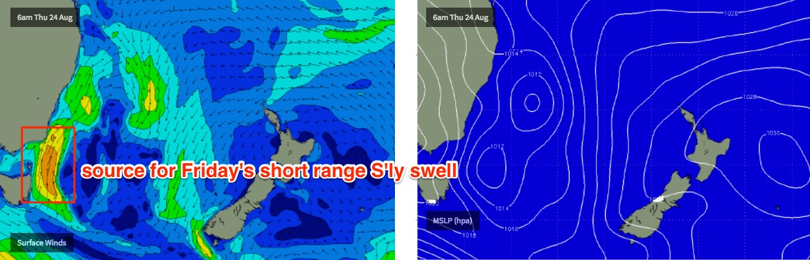
Friday looks the most interesting day of the working week though I suspect local winds will generally spoil the party. Thursday’s change will probably be linked in with a small Tasman Low forming east of Tasmania that’s expected to project through out immediate south swell window. This should generate around 4ft+ of short range south swell for Friday at the south swell magnets, though local winds will be fresh S/SW. There’s a chance for an early W/SW breeze in parts but it’s unlikely we’ll see any great quality. More on that in Wednesday’s update.
This weekend (August 26th - 27th)
Nothing overly special for the weekend - but there’ll be waves.
Friday’s short range south swell will ease into Saturday and conditions will improve quickly as winds tend light westerly in response to the low weakening and drifting into the Tasman Sea. Early morning should see 3ft sets at south facing beaches (bigger in there Hinter but smaller elsewhere) ahead of an easing trend throughout the day.
Sunday is currently on target for a small renewal in south swell thanks to a new front pushing into the lower Tasman Sea early Saturday morning. Again, no great size is expected but south facing beaches may rake in the odd 3ft+ set. We’ll be at risk of a southerly airstream but early morning should deliver periods of W/SW winds.
So, there'll be rideable at the swell magnets but nothing overly special. I’ll firm up the specifics on Wednesday.
Next week (Aug 28th onwards)
There’s a couple of interesting possibilities on the fringes of our swell window for next week.
The weekend’s Tasman developments may see an E/NE fetch crop up north of New Zealand thanks to a high to its east. If this system remains slow moving we may see some long range swell potential for the middle of next week.
In fact, the earlier stages of this development (in the NE Tasman Sea) are presently out of alignment for our swell window - that is, over the weekend - but could easily swing in favour over updated model runs (for an arrival time early next week). At the moment Tasmania’s East Coast may see a small NE swell early next week but Southern NSW (bar the Far South Coast) will probably just dip out. Let’s wait and see what happens.
Otherwise, we have another strong front due through the lower Tasman Sea in the first half of the week that should set up a strong southerly groundswell through the second half of next week. More on that in Wednesday’s notes.
Comments
As much as I love those clean 4ft south swells that make some breaks pump. Bring on the north east swells to get the beachies cooking
Still some strong late full tide sets in Newcastle
Been on the pump up here on the L/M/N/Coast Sun & tday offering some real power @ selected locals