Plenty of south swell ahead this week

Sydney, Hunter and Illawarra Surf Forecast by Ben Matson (issued Monday 7th August)
Best Days: Most days should have clean conditions and varying degrees of south swell. Best pulse looks to be late Thurs/early Fri.
Recap: A small E’ly swell provided fun waves at exposed beaches on Saturday with inconsistent sets to 2ft+, but surf size became tiny into Sunday, maintaining minuscule conditions into today.
This week (August 8th - 11th)
A deep Tasman Low is forming east of Tasmania, and strong fronts wrapping around its western flank will generate fresh southerly swells for the next few days.
The models are undercalling this event, mainly due to the SW fetch direction - which will create a very wide range in size between exposed south facing beaches and protected locations - however we’re looking at four days of varying degrees of south swell as various segments of the low send a series of small to moderate, back-to-back pulses of south thru’ south/south-east energy to Southern NSW.
Before I get into the specifics, and without wanting to repeat myself for the rest of the forecast period, I’ll reference size for south facing beaches - so each day we can expect much smaller surf at beaches with less southerly exposure.
Now, instead of estimating a blow-by-blow account of how each day’s swell will trend - which I think is pretty hard to pin down precisely - I think it’s better to throw down a blanket assessment of the week, and highlight a few key features throughout the forecast period that will contribute to bigger embedded pulses.
And that is: we should see a steady undercurrent of south swell starting from Tuesday morning (though beginning with a small base around dawn), and then holding into Friday afternoon. As a minimum, from about lunchtime Tuesday onwards, south facing beaches should see 2-3ft surf but there are several embedded features that are likely to kick up wave heights above this.
First of all, I really like how a small (modelled) fetch of core SW winds off Eden hang around through most of Tuesday, almost in a stationary position. The fetch alignment isn’t great for us but these kinds of slow moving systems often over-perform so the resulting energy from this should fill into Sydney beaches mid-late Tuesday afternoon, with sets around 3-4ft (bigger in the Hunter). This should persist into Wednesday morning but may ease throughout the day and especially into the afternoon.
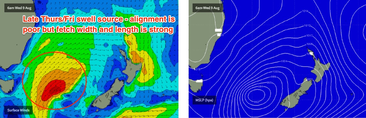
A second, broader SW fetch - but further away away from our coast (east of Tasmania) develops on Wednesday though its poor alignment won’t favour us very well but overall wind strengths are much higher and the fetch is bigger so we should see a better spread of S/SE swell fill in on Thursday, probably the afternoon.
Early morning will probably be undersized - being between swells - but the late session should nudge 3-4ft+ at south facing beaches, holding into Friday morning before easing throughout the day. We should see bigger surf across the Hunter, around 4-5ft, possibly even one or two 6ft sets. If anything, this swell has the potential to deliver occasional bigger bombs here and there due to the longer swell periods. I'll have a better idea on this in Wednesday's update.
Also in the mix on Friday will be a new SE swell generated by a strong E’ly fetch off the South Island of New Zealand late Tuesday and Wednesday. I mentioned this Sydney in Friday’s notes but the models have moved it around since then, weakening it and focusing it south of Tasmania, so we’re looking at inconsistent 2-3ft sets filling in concurrently with the pre-existing (and easing) S/SE swell throughout Friday.
As for winds - they’ll be offshore all week - moderate to fresh W/SW Tuesday, easing W/SW Wednesday then moderate W/NW Thursday and Friday ahead of a late W’ly change. So, a whole week of great conditions for the open beaches.
This weekend (August 12th - 13th)
A strong succession of powerful fronts exiting eastern Bass Strait from Friday onwards look a little too westerly in alignment to benefit our coast, however this is our only source of swell for the weekend.
Being an optimist, there’s a chance for 2-3ft+ sets at south swell magnets (upper end of this size range in the Hunter, possibly even some bigger waves) but a lot of locations will probably dip out completely due to the acute swell direction.
Let’s take a closer look on Wednesday.
Next week (August 14th onwards)
There’s nothing of great interest in the long range charts, however I do note that there is a suggestion for a small tropical feature to drift south of the Fijian region early next week which may provide a mid-late week round of E/NE swell for us. I’ll keep a close eye on this in the coming days.
Comments
Hmm looks good for a few south swell magnets just south of my local. Ben will winds be offshore all day here on the lower Mid Nth Coast or can we expect on shores to develop in the arvos?
New south swell starting to show at Cronulla now.
Nice J-curve at the Port Botany buoy!
More activity showing at Cronulla now too, easy 3ft+ sets at the northern end of the Bay.
Small peelers at the Island.
Not a bad size for Manly given the S swell direction.
Solid in Newy too.
Queensie still picking up some fun waves this morning despite the S'ly swell direction.
Newy is still pretty solid too.
Lots of size across Freshy on the sets..