Small weekend; late next week looks great with a new SE swell

Sydney, Hunter and Illawarra Surf Forecast by Ben Matson (issued Friday 4th August)
Best Days: Sat: small intermittent E'ly swell at exposed beaches. Thurs/Fri/Sat: strong, quality SE groundswell with good winds.
Recap: We’ve seen a slow easing S/SE swell from Wednesday through Thursday (early 3-4ft sets) and today (2-3ft sets). A small NE windswell was evident at exposed beaches early this morning but it’s quickly eased throughout the first few hours of the day. A small pulse of new E’ly swell is due later today but it’s not yet showing on the buoys. Conditions are clean with offshore winds.
This weekend (August 5th - 6th)
Surface conditions are looking excellent this weekend. But, there won’t be a lot of surf around.
You will have to make the most of Saturday if you're planning to get wet at all. The small new E’ly swell I am expecting later today was generated by a small but decent mid-week E/SE fetch exiting western Cook Strait (the body of water between NZ’s North snd South Islands) and although it’s not here yet, satellite passes on Thursday morning showed a healthy 30kts+ extending into the Tasman Sea.
The bigger waves will be rather inconsistent, and not every beach will fare well - but reliable swell magnets should pull in occasional 2ft+ sets. It’ll be clean with moderate W/NW winds.
On Sunday, this swell will fade right back and with no new swell expected, we’re looking at very small, weak surf with freshening NW winds.
Next week (August 7th onwards)
A significant cold outbreak will push across the SE corner of the country this weekend, however this system is riding quite north in latitude so the pre-frontal flow will be NW through most of our southern swell window.
There are a couple of regions of our south swell window, and they’ll each fire up through the early part of next week.
Our long range south swell window will see a polar low move north-east to a position south of Tasmania on Monday, but we won’t see any swell from this until late Wednesday. In fact, it’ll be a slightly different system generating most of the surf for us, as the polar low will give way to a smaller secondary feature, developing as a small part of the primary mid-latitude low crossing the mainland.
Anyway, the main low will eventually bring about a period of gusty S/SW winds in the western Tasman overnight Monday and into Tuesday. So Monday will continue the theme of tiny clean surf, ahead of a rapid increase in average, short range S’ly swell through Tuesday.
The models are only calling 3ft at south facing beaches through the day however I think there’s a reasonable chance for an upgrade with windy 3-5ft surf at times at exposed locations on Tuesday, with smaller surf at beaches with less southerly exposure. It’ll just depend on how strong the winds become off the coast. I’ll update over the weekend with more information.
However, better surf is on the way for the rest of the week. The mid-latitude low will take up residence off the SW tip of New Zealand’s South Island around Tuesday, and a combo of south swells will push through Wednesday, probably maintaining average 3-5ft surf at south facing beaches and smaller surf elsewhere. Winds should start to ease from the SW, veering back to the W/SW across most coasts, though the Hunter often cops the trailing breezes from the fronts so conditions may not improve here for another day or so.
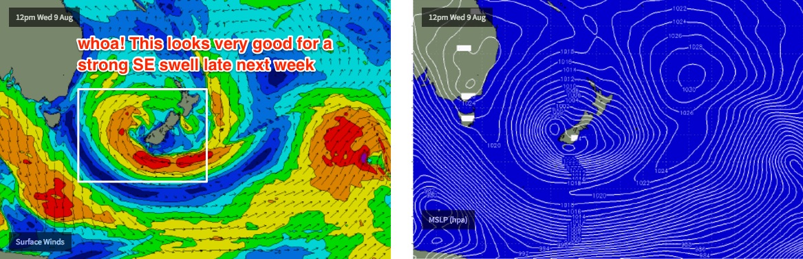
Of more interest are two strong fetches developing around the core of the low, near NZ - one southerly (off the west coast), and the other easterly (off the south coast) - see the chart below. Strong secondary fronts will then wrap around the low through Wednesday and Thursday. But the strong easterly fetch feeding from the lower SW Pacific, under NZ and into the Tasman Sea is a very exciting development and one I'll be watching very closely over the coming days.
This pattern should give rise to an extended period of quality SE groundswell, from sometime Thursday (probably the afternoon) through Friday and Saturday. At this stage we’re on track for strong, consistent 4-6ft sets at most open beaches, though I'll revise the specifics in next week's updates.
Have a great weekend!
Comments
Latest model runs have bumped up Tuesday swell from 3ft south facing to 6ft! (as mentioned in the notes above, published 90 mins ago).
So both Tues/Wed could see 4-6ft surf at south facing beachs. But let's not get ahead of ourselves - one model upgrade is a small part of a complex system with many moving parts.
They're also not as keen on the Thurs/Fri/Sat swell but it's still very early days.
Looks like Newy is picking up this small E'ly swell the best. Everywhere is extremely inconsistent though.
Pretty small and weak at Manly, just pushing an infrequent 2ft on the sets.
Couple of waves at Maroubra too but again, pretty weak and very inconsistent.
Twas a nice surprise to see the amount of swell on offer. Consistency was good too! (compared to some sessions last week) Surfed the point out Newy for about an hour on my own around this time on a new board. Fun was had.
Yeah looked pretty fun. Stoked you got a few! Doesn't look like there's much around this morning though.
Lookin good for a few days of south/east g/swell Ben! The models look very impressive hopefully it'll all come to fruition & deliver the goods!
Newy for the win today. Only two blokes on this bank!
Still small but a few peelers in Manly.