Fun week of south swell ahead

Sydney, Hunter and Illawarra Surf Forecast by Ben Matson (issued Monday 24th July)
Best Days: Most days from now until Saturday should have good south swell and clean conditions; Thursday the only exception as we may see winds veer S/SW for a period.
Recap: The weekend saw large, clean S/SE tending SE groundswells (last Monday, I mentioned “it’s shaping up to be the best weekends of winter waves thus far this season”), reaching 8-10ft at reliable swell magnets though smaller at many beaches in the 6ft+ range. Surf size seemed to peak Saturday lunchtime on the South Coast, and from Sydney to the Hunter late Saturday, however Sunday remained quite strong and sizeable through the morning before easing into the afternoon. Conditions were pretty much perfect both days except for an unusual period of W/NW gales across a narrow stretch of the Illawarra, due to a spell of katabatic winds. Today has revealed much smaller, easing surf across the region, 3ft sets at dawn in the Hunter and 2ft+ across remaining south facing beaches, and smaller elsewhere. A small new unrelated south swell is now filtering into south facing beaches, of a similar size as per this morning, perhaps a little bigger at times, sourced from a front passing east of Tasmania on Sunday. Great conditions have persisted all day too.
This week (July 25th - 28th)
We’ve got some good waves ahead over the coming days.
Light offshore winds will persist through Tuesday, and whilst today’s south swell will ease in size, it’ll be replaced by a long period S’ly swell generated by a deep polar low traversing south of Tasmania over the weekend. There’s a chance that the dawn session may see slightly undersized surf ahead of its arrival (though it should be in across the South Coast early), and we’re looking at a building trend into the 3-5ft range across most south facing beaches through the day, providing the biggest sets late afternoon ahead of an overnight peak, reaching 4-6ft across exposed Hunter locations. We will however see much smaller surf at protected locations owing to the strong southerly swell direction.
Winds will freshen from the W/NW into Wednesday and this pulse will slowly ease from a very early 3ft+ across south facing beaches (bigger 4-5ft sets in the Hunter), down to 2-3ft throughout the day, probably mid-late morning onwards. Winds will veer more W/SW but conditions should remain clean.
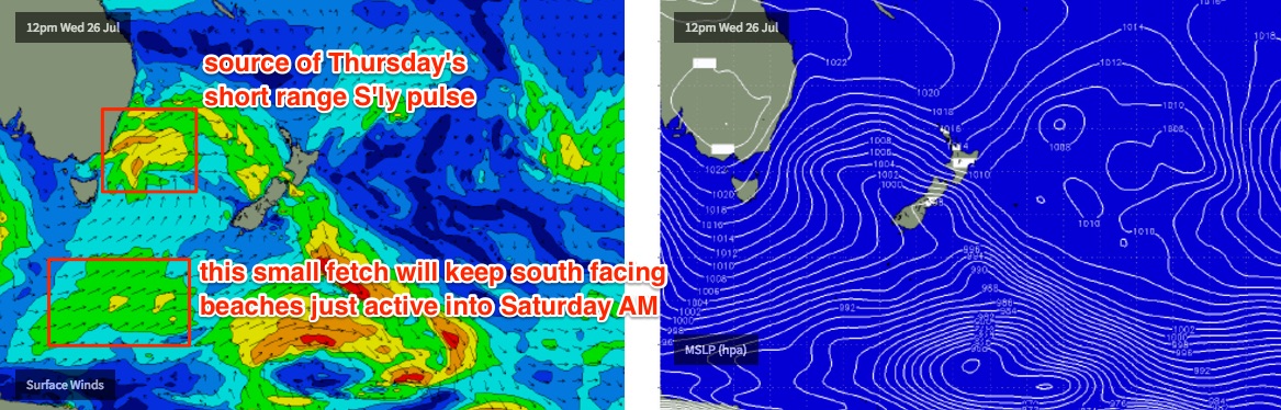
A strong front exiting eastern Bass Strait on Wednesday will kick up a short range S’ly swell for Thursday. In fact, there’ll be a couple of swell trains in the water, as the source for the Tuesday/Wednesday swell will remain active as a broad polar low, well SW of New Zealand over the coming days. This will supply plenty of small but long period south swell right through into the weekend, somewhere in the 3ft+ range both Thursday and Friday.
Thursday’s additional short range swell should nudge this figure a little higher though (maybe some 4-5ft sets at south facing beaches, bigger in the Hunter), but conditions are looking a little dicey with winds expected to veer from an early W/SW to the S/SW during the day as a weak front clips the coast. Protected locations will again be much smaller.
Wave heights will settle back on Friday and conditions will improve ten-fold as winds tend north-west ahead of the next front.
So, three of the next four days of the working week looks very good if you like mid-range south swells; even Thursday should have some halfway decent waves if you’re prepared to compromise a little in the quality department.
This weekend (July 29th - 20th)
An approaching zonal flow of strong fronts will be poorly aligned within our swell window, so the weekend’s looking at easing residual south swells and freshening NW winds.
Saturday looks to be your best bet with early 2-3ft sets at south facing beaches, easing throughout the day (a little bigger in the Hunter). Sunday could end up being very small indeed.
Next week (July 31st onwards)
Nothing major showing on the charts right now, so next week will probably rely on a couple of flukey swell sources to keep us active.
Comments
Keep the waves coming Huey! T'day was fun beachies in the 2ft + range with the odd bigger one, clean offshore and water still good temp. Even spotted a turtle checkin out the lineup !
Swell is in, easy 4ft sets across Curly..
Nice lines pushing into Cronulla Point.
Nice lines standing up across Wollongong. Not bad for a south swell!
Hey Ben - any rhyme or reason as to why the Illawarra had katabatic winds but say the northern beaches doesn't? Both get the early morning offshores more than say Cronulla. Any forecasting tips on how to pick it? I was in Shellharbour a few years ago mid winter and it was blowing very hard but an hour each way wasn't.
It's outside my area of expertise, but related to specific topography.
The Illawarra escarpment has a broad flat area to the east (Maddens Plains et al) where cold air pools, and then eventually drains down to the coast (generating strong winds). The Northern Beaches topography is however more narrow and complex due to the proximity of Sydney Harbour, and also the Pittwater. There's not as much area for the cold air to pool, the topography isn't as high in elevation, and there are many more drainage points for the air to flow to.
Not sure how to forecast it either, it's not something I've really looked at in close detail. Localised events like this are very difficult to get a handle on.
There's a good paper on it here: http://ro.uow.edu.au/cgi/viewcontent.cgi?article=1010&context=wollgeo
Here is an excerpt:
"In winter time, especially on cloudless still nights, the ground surface rapidly loses heat as outgoing longwave radiation escapes from the earth's surface. Above the escarpment where temperatures are cooler to begin with, because of elevation, a layer of cold dense air begins to accumulate above the ground surface. This air behaves exactly as a fluid and flows downslope into nearby drainage courses end valleys. Because the movement is induced by gravity these winds are termed gravity winds and the steeper the topography, the faster the wind speed. In the IIIawarra these gravity winds are often found after 10.00 p.m. at night seaward of valleys cutting Into the escarpment at Stanwell Park, Coalcliff, Macquarie Pass and other scattered locations. Katabatic winds are restricted to the lower 100-200 metres of the atmosphere and are not to be confused with regional westerly winds which will destroy gravity winds by overturning air through turbulence. In this latter situation it becomes impossible for cool air to accumulate near the ground. Gravity winds, once they leave the valleys or reach the ocean, rapidly spread out. Because these winds move downslope they force upwards the warmer air they replace and create local inversion conditions. Inversions, which occur when warm air overlies cooler air, are very stable, prevent any upward movement of air and hence trap pollutants in the lower atmosphere."
Thanks - interesting although fairly logical I guess. The difficulty is clearly in forecasting when it's going to happen!