Coupla south swells on the way this week; big and windy Friday

Sydney, Hunter and Illawarra Surf Forecast by Ben Matson (issued Monday 26th June)
Best Days: Tues/Wed: small flukey south swells. Don't get too excited. Fri: large windy south swell. Sat: large, easing south swell with lighter winds. Sun: moderate S'ly swell with offshores.
Recap: Saturday saw easing E’ly swell and offshore winds. Sunday delivered a combo of long period and mid period south swell from two sources - the long period energy originated from a deep polar low that formed under WA on Tues/Wed last week, in a remote, acute parent of our flukey south swell window. The mid-period energy originated from a front that tracked east of Tasmania on Friday night.
The two swells arrived simultaneously (the mid period swell lagged slightly behind expectations) and produced strong surf on Sunday around 3ft at south facing beaches in Sydney, whilst the reliable south swell magnet region of the Hunter region saw bigger surf - Swellnet forecaster Craig Brokensha picking up 4-6ft sets for a few hours at an exposed beachbreak. Note: this is the same swell that produced mackin' 10-12ft surf at Bells Beach on Saturday.
Interestingly, MHL's standard buoy data graphs didn’t show peak periods as being very high on Sunday, however this is most likely because of the simultaneous swell trains. Tp, or “peak period" is the period associated to the most energy (i.e. not "max period"). So whilst there were certainly 16-18 second swell periods in the water on Sunday (18 seconds was recorded off Tasmania on Saturday), it was obviously a weaker signal than the energy generated by Friday’s front.
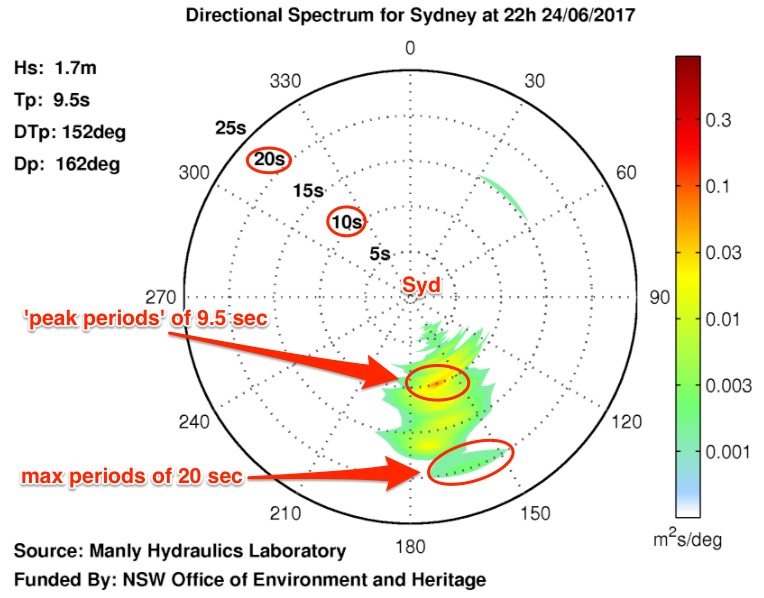 To that end, see the image to the right - this is spectral data from the Sydney buoy off Long Reef, at 10pm Saturday night - which shows the energy distribution at a single point in time. Swell periods extend outward from the centre (i.e. highest values on the edge of the circle), swell energy is proportionate to colour, and direction is as per the compass bearing. This confirms that there was a faint signal at 20 seconds at 10pm, whilst the strongest signal was in and around 10 seconds (indeed Tp was recorded as 9.5 seconds). Over the following hours (i.e. into Sunday), later spectral readings showed the long period swell had eased to 16-18 seconds.
This week (Jun 27 - 30)
There are a couple of sources of new swell for the coming days. However, the models have downgraded the strength of a S/SW fetch pushing through the lower Tasman Sea today, and our model doesn’t seem to be picking up the new swells very well either - estimating just 2ft sets at south facing beaches for the next few days.
The fetch trailing the Tasman front is broad but not terribly strong, and it won’t hang in the swell window for very long either. This should produce 2ft to very occasionally 2-3ft sets at south facing beaches throughout Tuesday, and it’ll be clean with light variable winds. Most beaches not open to the south will be considerably smaller however we can expect a few bigger waves again (another foot or more) across the Hunter.
On Wednesday, this south swell will fade but it’ll be replaced by a new long period S’ly swell generated by a polar low traversing below the continent yesterday.
Surface winds are much stronger but the fetch is poorly aligned so we’ll see swell energy glance the coast during the day. This should produce occasional 3ft sets at south facing beaches in Sydney, with bigger surf across the Hunter but again, much smaller waves at beaches will less southerly exposure. Light offshore winds will again maintain clean conditions. Expect there to be considerably longer breaks between the sets on Wednesday - this is not a high confidence swell event.
Freshening offshore winds are expected on Thursday with an approaching cold front, and our mid-week south swells will slowly ease in size - aim for the morning session for the biggest waves (inconsistent 2ft+ sets at south facing beaches early, bigger in the Hunter but smaller elsewhere).
The front will race off into the Tasman Sea on Friday, forming a low pressure system mid-way between Tasmania and New Zealand and driving gale force S/SW winds across the western Tasman Sea. This will set up a large, windy south swell for Friday that should build into the 4-6ft range at south facing beaches throughout the day, possibly a few bigger sets very late - but winds will be fresh and gusty SW so you’ll need to look for some protection. Again, bigger surf is likely across the Hunter.
This weekend (Jul 1 - 2)
Its pretty easy formula for the weekend - an early peak in large south swell, easing thereafter. Winds should veer to a light W’ly both days, trending more SW on Saturday and then NW on Sunday but some exposed beaches (mainly Hunter) could see a lingering southerly effect early Saturday thanks to Friday’s windy conditions.
Saturday morning’s likely to maintain a similar size as per late Friday, somewhere in the 4-6ft+ range at south facing beaches (bigger in the Hunter) but it’ll be down to 3-5ft by the afternoon and then 3-4ft easing to 2-3ft on Sunday. Again, expect smaller surf at beaches with less southerly exposure.
All in all it's currently shaping up to be a pretty typical winter south swell for southern NSW. And with good conditions to boot.
Next week (July 3 onwards)
At the moment there's nothing major expected in the surf department next week, just an easing trend for the first few days as the storm track focuses away from our swell window over the weekend. Conditions should be clean for the first half of the week with mainly offshore winds.
A new south swell is possible around Thursday with a fresh frontal passage through the lower Tasman Sea.
More on this in Wednesday’s update.
Comments
Here's a little more info re: Sunday's buoy data - this is the MHL trace from Sydney for the last few days (Sunday was the 25th, if you're looking at this in a few days time).
It shows that "peak periods" briefly spiked at 12.9 seconds around 4-5am, then settled around 10 seconds for most of the day.
gday ben, could we still expect forecasted 2-3 ft at magnets down the coast tomorrow?
Sorry mate, missed this. Looks like the south swell(s) have come in bang on forecast expectations - Craig reckons there's good 3ft sets across the Sydney region.
All good. Compliments on the forecast mate. Was 3-4 ft.
Thanks! Stoked you scored. Pretty dribbly up north right now.