Late Wed and Thurs for a new S'ly swell

Sydney, Hunter and Illawarra Surf Forecast by Ben Matson (issued Monday 12th June)
Best Days: Wed: keep an eye out for an afternoon kick in long period S'ly swell. Thurs: inconsistent but fun, easing S'ly groundswell with good winds.
Recap: Slowly easing E’ly swell over the weekend remained just north of expectations, easing from 3-4ft Saturday, 3ft today and 2-3ft this morning. Conditions slowly improved all weekend and this morning has delivered fantastic offshore conditions with peaky beach breaks on offer.
This week (Jun 13 - 16)
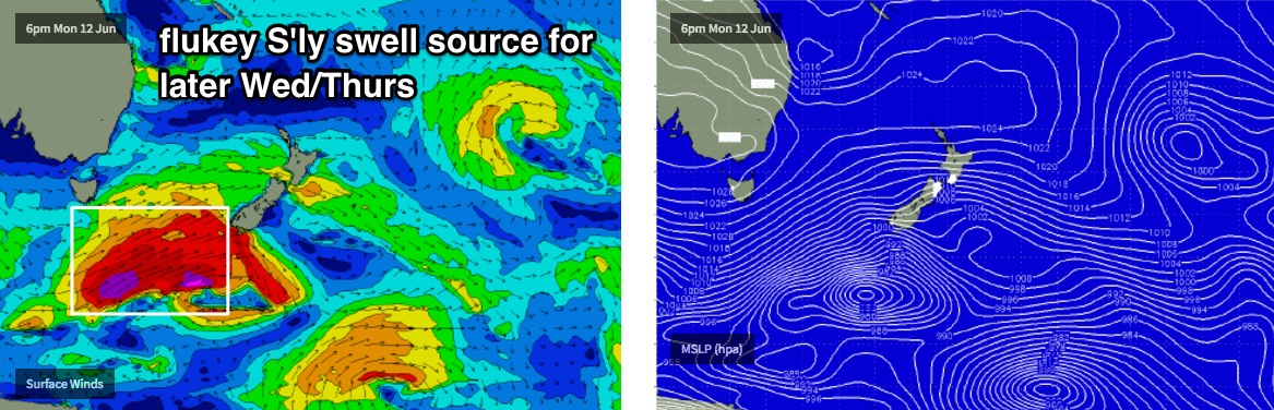
The synoptic charts are very dynamic this week but ultimately - with the exception of one southerly swell - there’s not a great range of new surf on the cards.. for now anyway.
A series of small, long period southerly swells are expected to glance the coast from today through Wednesday morning, but as they have originated from distant, poorly aligned Southern Ocean lows, I’m not expecting much size from them.
However, the final low in the sequence is tracking below Tasmania today and it's a little better positioned, and should provide a late kick on Wednesday afternoon across south facing beaches, with occasional 2-3ft+ sets (bigger in the Hunter). Only reliable south swell magnets will pick up energy from this source, as it’s quite a flukey alignment within our swell window - and the Hunter region usually does best. I doubt we’ll see much new energy before lunch though.
Thursday will be the biggest beneficiary of this south swell with early 3ft+ sets at south facing beaches (bigger in the Hunter), easing during the day. Expect much smaller surf at beaches with less southerly exposure. And, there'll also be a considerable wait between sets too. However conditions look best this week on Thursday with light offshore breezes.
Prior to this, the small E’ly swell prevalent in the water today - which came in above expectations - is expected to slowly ease throughout the next few days. So we should see some small beach breaks on Tuesday and Wednesday though nothing of any great size or strength.
As it is, a moderate southerly change will clip the coast on Tuesday anyway, creating bumpy conditions at exposed beaches. So keep your expectations low. Winds will then ease overnight and become light and variable into Wednesday.
A reintensifying trough off the North Coast today looks like it’ll remain focused into that region, without much direct influence on our coastline for the short term. However, a NE infeed into the trough’s eastern flank may generate a small pulse of mid-range swell for us mid-week (later Wed/Thurs). Again, it’s a low confidence even from a flukey source but 2ft sets are possible at times.
As for Friday, we’ll probably finish the week with small residual swells from the NE and S, with the latter bring most dominant but both swells easing during the day. The models maintain an unstable troughy pattern across the coast through the week and there’s a suggestion for a small low to form east of Sydney around Friday, but at this stage is not expected to be a significant swell generator. It may however freshen winds from the south.
This weekend (Jun 17 - 18)
The lingering trough parallel to the East Coast all week is expected to perk up around Thursday or Friday, though confidence is only low as to what will happen locally on the synoptics.
However there seems to be a reasonable chance that we’ll see a modest NE fetch well off the Northern NSW coast later in the week that should generate a small NE swell for the weekend. No great size is expected (and the timing isn't clear either) but it’s something to watch over the coming days as the models update.
Otherwise, an approaching cold front is expected to merge with the trough later in the weekend, eventually generating a large south swell - but probably not until around Monday. As such, Sunday could be in between events with small swell sources and tricky winds.
So, we really need a few more days before we firm up the weekend outlook - there’s just too much going on within the charts, too close within our swell window to be confident one way or the other.
Next week (Jun 19 onwards)
An amplifying node of the Long Wave Trough across our south swell window on Sunday is expected to kick up a strong south swell for early next week. It’s still along time away - and keeping in mind that the end of the model runs have been quite ‘explosive’ for the last few weeks - so we need to take this outlook with a grain of salt.
However it does look like we’re in for an extended run of sizeable surf for much of next week. Wave heights should push north of 6ft during this episode, but it'll probably be windy from the S/SW quadrant.
I’ll also be keeping a close eye on the model’s projections of the eastern flank of the Tasman trough over the weekend (prior to the LWT activating strong southerly winds early next week). At this stage a developing E/NE fetch in the central Tasman Sea during this period looks impressive as individual snapshots, but as a sequence is moves too fast, and too far SE to benefit swell production for NSW. It doesn’t take much of a tweak in the model guidance for things to move back in favour for us though, so let’s investigate in more detail on Wednesday.