Stacks of swell ahead for Sydney, but tricky winds

Sydney, Hunter and Illawarra Surf Forecast by Ben Matson (issued Wednesday 7th June)
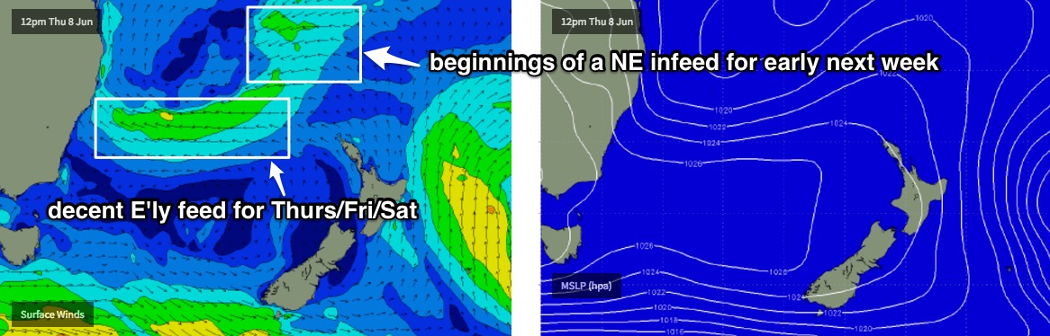
Best Days: Thurs/Fri/Sat/Sun: plenty of E'y swell, with pockets of OK conditions. Mon onwards: tricky outlook but lots of swell on the cards, possibly large with an ECL forming east of Sydney.
Recap: A cold front and developing low off the coast freshened winds from the SW on Tuesday, tending S’ly this morning and now SE across the region. However winds are still W/SW thru’ SW across the northern Hunter (i.e. Newcastle) owing to the close proximity of the low. Surf size built only gradually across south facing beaches Tuesday afternoon and today has come in under size expectations (3-4ft against a forecast of 4-6ft), though the buoy data suggests a different, much larger story - significant wave heights off Sydney of 4.3m (14ft), maximum wave heights of 8.1m (28ft) around dawn.
This week (Jun 8 - 9)
I’m kinda surprised we haven’t seen more size across Sydney beaches today.
If you’d looked at today’s buoy readings in a few months time, and then been asked to estimate how big the surf was - with significant heights over 4m and maximum heights of 8m - I reckon you’d guess a lot bigger than 3-4ft at south facing beaches.
But hey, that’s one of the lovely curveballs in surf forecasting.
Anyway, this is all a moot point as today’s conditions were expected to be pretty craptacular. So, no harm done.
Thursday looks tricky but we should see a decent improvement as the low slowly moves north, allowing winds to relax across the coastal margin. We will still probably see periods of onshore winds across some regions - such as the Hunter coast - but elsewhere winds should generally ease to become variable during the day, and if we're lucky we may even see light offshores in parts. Expect some surface bumpiness at first but a slow improvement during the day.
As for size, the local windswell from today will ease, and we’re looking at a building E’ly swell throughout the day. The latest model guidance has slowed and marginally weakened the responsible E’ly fetch around the southern flank of the Tasman Low, but it’s also holding it for a little longer which means E’ly swell will persist through Friday and Saturday.
But back to Thursday - the morning session is therefore likely to be ‘between swells’, and with tricky conditions it’s hard to be confident in anything worthwhile. But the mid-range E’ly swell will start to show through the middle of the day and by mid-late afternoon should be producing 3-4ft surf at most open beaches between the Hunter and the 'Gong.
This size range is expected to persist through Friday, possibly with a handful of bigger sets at the swell magnets, but generally in the 3-4ft range. Winds will probably remain similar too, generally light and variable through the morning with a risk of moderate onshores at times.
An approaching southerly change off the Far South Coast probably won’t impact the Sydney regionto any great degree, but it is likely to have some influence in renewing the broader onshore flow at some point. So I’d give these onshores a reasonable chance of occurring into the afternoon, but the morning should offer pockets of semi-decent surf conditions north of Wollongong and south of the Central Coast.
This weekend (Jun 10 - 11)
We’ve had yet another major model swing in the last few days.
Friday’s southerly change has been weakened considerably, and instead of a new Tasman Low forming, we’re likely to see the incumbent system - by this time meandering just off the Mid North Coast - hugging the mainland, and slowly broadening a surface trough to the north.
Therefore, the upshot for our surf potential this weekend is an initial easing but otherwise levelling of easterly swell, from 3-4ft+ to 3ft+ across most open beaches (smaller south of the Gong).
Winds are expected to slowly freshen from the SE or maybe E though there’s only low confidence on the specifics, as we’ve already had a lot of chops and changes in the last few days. So I am expecting this to move around before the weekend once again.
So, short story is: plenty of east swell, but tricky winds.
Next week (Jun 12 onwards)
If the latest model guidance is to be believed - and there’s loose agreement across the board right now - the coastal trough/low across Northern NSW this weekend will slide south to a position off the Central NSW coast, before intensifying an East Coast low on our doorstep around Monday or Tuesday.
We’d see a couple of swells from this setup - residual E’ly swell from the weekend, building NE tending E’ly swell from the associated tropical infeed, and then a very large local S thru SE swell from the core of the low.
But in reality there’s a vast number of possibilities with this system so we’re really going to have to watch the models day by day to get a grip on the overall trend.
But right now, it’s dynamic with no shortage of size on the long term charts.
See you Friday!
Comments
probably my fav swell direction from the east. Shame bout the winds. Hope fully get a few new sand banks as it's a bit of mix bag at the moment
Thanks Ben, great notes as always. Can we expect any south swell from the low passing under NZ on the Fri 10pm weatherzone chart? Hoping for some nice lines wrapping into the south coast around Sun AM ;-)
Nah, too zonal in structure and forms too late in the swell window.
But check the massive polar low passing south of Tas on Saturday! Again, very zonal but its location (just on the western periphery of our south swell window) plus a much broader fetch width gives this some potential for a south swell mid-next week. Though only in the absence of a major swell from the Tasman.. which wasn't likely yesterday but has changed a bit overnight with the latest model runs.
Thanks Ben! Yeah saw that but mid next week doesn't help me (weekend warrior Monaro area).
Good luck with the banks scouser. I would think next week's swell is more likely to steepen the drop off and send them deeper.
The beaches round the cc are pretty wide round my neck of the wood with the banks pretty close and compact to the beach.
Looks like the boog is going to get a good run over the next week or so.
Big change to next week's model guidance overnight (surprise surprise). Still a very active period for the Tasman Sea but it's now suggesting most of the activity will occur further north.
It'll change again overnight for sure.. hang tight!
Won't be any shortage of waves next week anyway.
Loving the daily update thanks Ben!
Decent size out of the east this afternoon.