Strong southerly swells ahead

Sydney, Hunter and Illawarra Surf Forecast by Ben Matson (issued Wednesday 18th January)
There's only two weeks left to sign up for the P-Pass competition! Sign up to Swellnet’s newsletter and receive the Sydney, Hunter and Illawarra Forecaster Notes and latest news sent directly to your inbox. Upon signup you'll also enter the draw to win a surf trip to P-Pass for you and a mate. It doesn’t get much easier so click HERE to sign up now.
Best Days: Thurs: improving conditions with a solid S'ly swell. Fri: chance for a window of offshore winds in the afternoon along with a mix of easing S'ly and building NE swell. Sat: strong S'ly swell with improving conditions. Sun: small fun mix of S and S/SE swells with light winds. Mon: Fun but inconsistent S/SE swell with freshening NE winds.
Recap: The flukey south swell we saw on Monday eased through Tuesday though reliable south facing beaches along the Hunter picked up early 3ft sets. Surf size leveled out at an inconsistent 1-2ft today and conditions were clean early with light offshore winds, ahead of a southerly change which pushed through mid-morning and has bumped up the open beaches this afternoon. A small windswell is now building across the coast.
This week (Jan 19th - 20th)
Now that the ocean has settled down from the early-week south swell energy, we can start the forecast with a clean slate.
We have a couple of swells due in over the coming 48 hours. A strong front is pushing through the lower Tasman Sea, and is generating a solid south swell that will fill in throughout Thursday. South facing beaches should pick up 3-5ft sets, with bigger bombs approaching 6ft through the Hunter. However beaches not open to the south will be much smaller.
The current gusty S’ly airstream is expected to relax overnight as a high pressure ridge builds through the south-western Tasman Sea. This will swings around to a light E’ly breeze, though early morning may see a lingering moderate S’ly wind across the Hunter region.
In fact, local topographical influences should give rise to the possibility of localised areas of early light SW winds, especially south of Wollongong and also across the Northern Beaches. So there may be some residual lumpiness on top but by and large surf conditions should be reasonably good.
Also in the water on Thursday will be an unusual long range S/SE swell generated by a modest polar fetch that developed south of New Zealand over the weekend. This was the bottom flank of the same low that delivered the erratic Mon/Tues S’ly groundswell. However, the large travel distance and the moderate surface wind speeds means we probably won’t see much than an underlying 2-3ft from this source.
These swells will ease steadily throughout Friday, initially an inconsistent 3ft at south facing beaches (a little bigger in the Hunter) but easing to around 2ft during the day.
Overnight on Thursday, winds are expected to swing to the NE and become quite gusty into Friday morning as a developing trough of low pressure east of Bass Strait spins up a closed low. These NE winds will generate a building NE swell that has the potential to reach 2ft to maybe 2-3ft at reliable NE swell magnets by Friday afternoon.
However - and this is important as it’s a good opportunity to score some clean A-frame beachies - as the low starts to develop to the south, winds will veer N’ly across Southern NSW, then NW, W’ly and eventually S’ly (overnight). As such, we’re looking at a possible window of clean beach breaks from early afternoon onwards, with a mix of easing S’ly and building NE swells around 2-3ft at open beaches. Keep an eye on the surfcams and you may very well score.
This weekend (Jan 21st - 22nd)
There’s not much change to my opinion on the low forming down south, with regards to its swell generating potential for Southern NSW.
The low will develop S/SW gales parallel to the coast overnight Friday and this will create a strong but brief peak in size for south facing beaches on Saturday morning. The models are pretty optimistic about this scenario and have pegged size around the 4-6ft mark but I think it’ll probably come in a little under this (4-5ft, though with bigger bombs across the Hunter), and the peak will be short lived too.
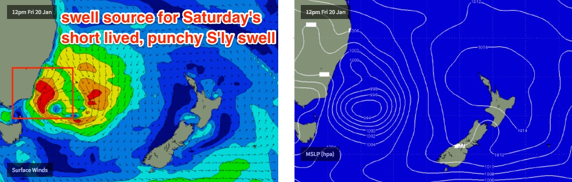
The low is expected to track quickly east, relaxing the pressure gradient across the coast and resulting in rapidly easing winds through Saturday morning. Most locations will probably still be under the influence of a moderate S’ly breeze though isolated regions (such as the Northern Beaches) should see a W/SW trend from just before first light. In general expect lumpy but improving surf throughout the day.
Saturday’s punchy S’ly swell will ease throughout the afternoon (model guidance suggests a peak just before lunchtime) and will abate further into Sunday from 2-3ft at south facing beaches (bigger in the Hunter), with smaller surf expected into the afternoon from this source.
However we’ll see a secondary S/SE groundswell build slowly in size at the same time. This will have originated from the distant polar fetch mentioned above (for Thurs's small swell),. This fetch is expected to remain active all week, though positioned a little closer to the ice shelf. Again, no great size is expected from this source and there’ll be very long breaks between the sets, but reliable swell magnets may see occasional 2-3ft bombs.
With light variable winds and sea breezes on Sunday, there should certainly be some fun surf at beaches open to the south.
Next week (Mon 23rd onwards)
Sunday’s long range S/SE swell is expected to peak into Monday, offering inconsistent 2-3ft sets across south facing beaches and a few bigger bombs at reliable swell magnets. There’ll be long breaks between sets and with freshening NE winds you’ll have to aim for a northern corner.
These freshening NE winds will also generate a building NE windswell for the afternoon and possibly early Tuesday, with low quality 2-3ft sets at exposed NE facing beaches. A strong front will then push across Tasmania during Tuesday morning, delivering a gusty S’ly change Tuesday afternoon and building moderate S’ly swells across the region through the middle of the week. At this stage no major size is likely but there’ll be options.
Otherwise, the polar swell source mentioned above (for the Sun/Mon S/SE swell) will reach a peak on Saturday which is expected to generate another pulse of fun S/SE swell around Thursday. At this stage no major size is expected and the increasing travel distance will only further space the time between sets. However swell magnets may pick up some 2-3ft sets. As mentioned on Monday, this is a really interesting, unusual swell source so let’s keep a close eye on it over the coming days.
Otherwise, there are no other notable systems standing out in the long range charts.
See you Friday!
Comments
Tuesday around midday saw punchy long period south swell on the lower/mid/nth/coast! GR8 waves but tday saw only
1to 2ft with offshores! Seems like we can look fwd to some more south energy this w/end & nxt week , bring it on!
woo-hoo! the dune buggy is packed and i'm headed south for a week!
When do you reckon the NW wind will hit tomorrow Ben around cronulla area??
Models have cooled a little on the idea of NW winds. However I still think it'll happen though more likely around mid-afternoon than lunchtime. And more of a gradual swing from the N/NE to the N then the N/NW then NW.
Still on track for a gusty early/mid evening S'ly change too; into the Sydney region around 9-10pm.
Should be alright if that 2-3ft NE swell is on track?
Winds are only light and Bondi's pulling in 4ft sets. Looks pretty fun.
Hey Ben - I have seen some models predicting the solid south swell to hit this afternoon (while winds are still NW-ish). Do you reckon that could happen?
No chance sorry boner, not sure which models would be showing that.
Willyweather is calling it Craig - must be in the wrong time zone or something:
http://swell.willyweather.com.au/nsw/sydney/bondi-beach.html
We can pray to Huey they are right!
Willyweather surf forecast is as "accurate" as Coastalwatch.. Stay clear!