Building south swell Friday arvo; strong south swell for the weekend

Sydney, Hunter and Illawarra Surf Forecast by Ben Matson (issued Wednesday 7th December)
Sign up to Swellnet’s newsletter and receive the Sydney/Hunter/Illawarra Forecaster Notes and latest news sent directly to your inbox. Upon signup you'll also enter the draw to win a surf trip to P-Pass for you and a mate. It doesn’t get much easier so click HERE to sign up now.
Best Days: Fri: afternoon building S'ly swell with a reasonable chance for decent winds. Sat/Sun: strong pulsey S'ly swell with light winds early. Mon: early light winds and easing S'ly swell.
Recap: Small surf has persisted for the last few days. A minor south swell built today but there's been no notable size across the Sydney basin.
This week (Dec 8th - 9th)
Looks like a mixed end to the week.
Restrengthening NE winds on Thursday will generate some local windswell for exposed beaches into the afternoon, but with fresh accompanying NE winds conditions won’t be very good. After starting from a small base early morning, we’re looking at mid-late afternoon sets in the 2ft range, possibly reaching 2-3ft right on dark if we’re lucky (and maybe some bigger sets across the South Coast owing to the longer fetch length). Quality won’t be high though.
Winds will veer NW then W/SW overnight as a front crosses the region, ahead of a synoptic SW flow developing throughout the day on Friday. Conditions will be super clean across most beaches for the early session, however the NE windswell from Thursday will be rapidly easing. We may see a few stray leftover 1-2ft sets at swell magnets around dawn but in general I’m not expecting much size. Whatever swell we do see at first light will be be gone by lunchtime.
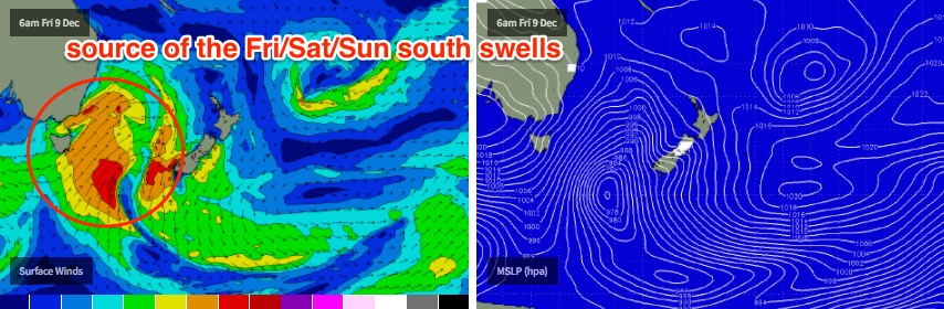
Fortunately, the models have slightly upgraded the strength of the front as it passes through eastern Bass Strait overnight Thursday. As such the southerly swell forecast for Friday has been increased since Wednesday’s notes.
We’ll be starting from a small base, but surf size should start to build from about late morning/lunchtime onwards, with a more pronounced increase expected from mid-late afternoon onwards. South swell magnets should reach 3-4ft right at the end of the day - this is slightly above our model predictions (3ft) but I’m confident that the fetch is aligned well enough to give us a good boost for the late session. Expect much smaller surf at beaches not open to the south, but bigger bombs across the Hunter (slightly delayed from the Sydney arrival time though).
Conditions should be OK for the afternoon paddle too; models are showing a moderate S/SE sea breeze late in the day but I think the broader synoptic SW flow should be able to override these effects.
This weekend (Dec 10th - 11th)
SW gales existing eastern Bass Strait and S/SW fales wrapping around the western flank of the parent low to the SE of Tasmania will generate plenty of south swell for the weekend.
And fortunately, conditions are looking very good with generally light winds and sea breezes both days, thanks to a broad high pressure system moving into the Tasman Sea.
South facing beaches will pick up the most size, with several pulses plateauing wave heights throughout Saturday afternoon and Sunday morning. The model’s slight increase since Monday has increased wave heights from 4-5ft to 4-6ft at south facing beaches, and broadly speaking I think this is quite plausible though I think the upper end of this size range (6ft) may be a little scarce across some stretches.
As always, surf size will be smaller at beaches not open to the south but conversely, we’re looking at easy 6ft+ sets across the Hunter region.
Surf size will ease through Sunday afternoon but should retain plenty of strength.
Next week (Dec 12th onwards)
A secondary front pushing through the lower Tasman Sea on Sunday has been downgraded in the latest model runs, and also aligned less favourably through our swell window, which means smaller wave heights and a later arrival across the Southern NSW coast than what was suggested on Monday.
We’ll start the week with mainly easing swells from Sunday (3ft+ south facing beaches, easing to 2ft+ during the day) though the leading edge of the new swell should reach the South Coast late in the day.
This small new south swell should show across most south facing beaches in Sydney on Tuesday, with inconsistent sets up around the 2ft+ mark. Elsewhere expect smaller surf, with freshening N'ly winds.
Otherwise there are no significant weather systems standing out on the charts right now.
See you Friday!
Comments
Is the early for friday morning still around the 1-2ft range? Maroubra area...
Still not expecting any major S swell until after lunch.
So, I was watching the surf an hour ago - 'bout half twelve - and took a screenshot of the biggest set I saw.
Then, just a few minutes ago I checked the Botany buoy.
Hello!
And a further check of the Bondi cam shows some lovely long straight lines of S'ly groundswell. Bang on cue.
Oh my!
Flat to 3"+ in 2 hours?