Strong S'ly swell due to peak Wednesday. Clean conditions most days

Sydney, Hunter and Illawarra Surf Forecast by Guy Dixon (issued Monday 23rd May)
Best Days: Each morning, particularly Wednesday.
Recap:
Saturday saw a peak in energy with solid sets breaking in the 3-5ft range across south facing beaches, more so in the 4-6ft range across the Hunter. This size eased from around 3-4ft on Sunday, furthermore today with sets back down to around 2ft range across the magnets.
Conditions remained clean for the best part of Saturday morning, with westerly breezes persisting right up until lunchtime. Sunday saw a similar setup, with breezes swinging onshore in the late morning. Conditions have been a little bumpy across the open beaches this morning under a northerly breeze, improved this afternoon as breezes swung offshore and became gusty.
This week (Tuesday 24th - Friday 27th):
A westerly fetch is currently exiting Bass Strait, steered by a strong front and small scale cut-off low situated just to the southeast of Tasmania. With a few hours, these 30-35kt westerly breezes will tend more west/southwesterly and intensify to around 35-45kts while also broadening and becoming elongated.
As Monday night turns into Tuesday morning, this system is expected to stall, forcing the pressure gradient to tighten along the western quadrants of the low. As a result, an elongated fetch should become established over eastern and southern parts of the Tasman Sea.
Mid range southerly energy off the initial fetches exiting Bass Strait should be in the water on Tuesday morning, building to around 4-5ft by the afternoon, larger on the Hunter and possibly a touch undersized along the South Coast due to the inability to spread in towards the coast.
Conditions are likely to remain clean throughout the day at most beaches as a west/southwesterly breeze persists.
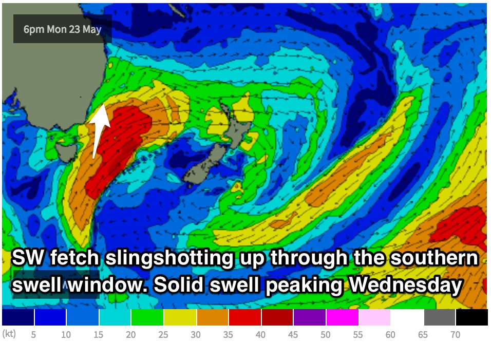 Much more substantial groundswell is due late on Tuesday and into Wednesday as a result of south/southwesterly fetches on the back side of the low slingshotting up through the southern swell window in a captured motion.
This energy should peak on Wednesday, with sets in the 5-6ft range at south facing beaches, potentially up to 6-8ft across the Hunter (which picks up southerly groundswells a lot better). Due to the acute swell direction, less exposed beaches are likely to be significantly smaller, while the offshore reefs may offer stronger sets.
West/northwesterly breezes are likely to lead to clean conditions throughout the morning, easing and tending variable before a light seabreeze develops during the afternoon.
Thursday will likely see a steady easing trend as the southern swell window takes a quick breather. Set should ease from around 3-5ft fairly rapidly across south facing beaches, again with size limited across the less exposed spots.
Northwesterly breezes should groom surface conditions throughout Thursday, with only a small chance of open beaches becoming wind affected during the early morning as winds are at their most northerly. Generally speaking, there should be no issues with quality, especially at the beaches picking up the mist size.
Meanwhile, a small low has the potential to develop off the coast of about Eden, intensifying quickly late on Thursday evening and into Friday morning. Small but intense fetches have the potential to steer 35-45kt winds up the South Coast, whipping up short range southerly energy late on Friday, likely peaking overnight. The late session on Friday may see the odd 2-3ft set at exposed south swell magnets.
Westerly breezes, although gusty at times should work hard to maintain clean conditions, persisting throughout the day.
This weekend (Saturday 28th - Sunday 29th):
As this system deepens and migrates across the Tasman, the southwesterly fetches will become poorly aligned, allowing the swell to ease from the 2ft range on Saturday.
Clean conditions should persist throughout Saturday, as west/northwesterly breezes become gusty and tend west/southwesterly.
Meanwhile, weak southeasterly fetches on the southern quadrants of this low may come into action, providing energy later on the weekend. These fetches look modest throughout the duration of the system, although their slow moving, persistent nature should provide a small amount of workable energy. Initially, mid-range energy should fill in late on Saturday steered by breezes over the central Tasman although failing to provide much additional size. Better energy is due to follow steered by a small southeasterly fetch anchored off the southern tip of New Zealand’s South Island. Sunday should see most of the gain, with sets in the 3ft range easing into Monday.
By this stage, a southwesterly airflow should be established, somewhat limiting the better options to less exposed beaches, particularly the southern ends. This will likely put a limit on size potential unless you’re happy to battle the bumps. A ridge should move over by Monday allowing for light offshore breezes during the early session.
Comments
thanks guy - very informative as always. a quick question - does the easterly / NE fetch currently off the SE of NZ come into play for the NSW coast at all? thanks
... before next weekend, i mean. thanks
It's not likely that we would see much swell off that fetch for a couple of reasons:
- The landmass of NZ is creating a swell shadow for that fetch, but this doesnt always discount a system...
- Because the Earth is a sphere projected onto a flat computer screen, a straight line actually appears as a curve known as the Great Circle Path. For the most efficient swell generation (for a particular point location i.e. Sydney) we hope to see a fetch blowing along that line of the great circle path (what we refer to as good or bad alignment). In this instance, this fetch seems to be blowing across or perpendicular to the great circle path. If it had a more southeasterly alignment and was positioned a touch further south, we could see small amount of swell.
thanks guy
Bondi is picking up some solid sets this morning.
Keep and eye on the surfcam at: http://www.swellnet.com/surfcams/bondi
Inconsistent but decent waves pushing through at Shark Island.
couple slow sets at southern exposures, got my local to myself this morn, couple nice bowls
Some bombs coming through Shark Island this arvo at surge. Easy 5ft on some
No shortage of size across Sydney beaches this morning.
So what size is it Stu?
Hey Simba, I just deleted those posts and re-uploaded in the current forecast. Save having a new convo in an old forecast page.