Thursday is the pick of the forecast period

Sydney, Hunter and Illawarra Surf Forecast by Ben Matson (issued Wednesday 2nd September)
Best Days: Thurs: mix of easing S'ly and new E/SE swell with early offshores. Sat/Sun: mainly light winds and a small/mod series of south swells
Recap: A large mix of S’ly and SE swell provided excellent waves right across Southern NSW on Tuesday, with 6ft sets at south facing beaches from Sydney to the South Coast, and larger bombs in the Hunter. Surf size eased a little overnight but was still managing 4-6ft across Sydney this morning (again, bigger in the Hunter) and conditions have remained clean both days with early light offshore winds and light afternoon sea breezes.
This week (Sep 3 - 4)
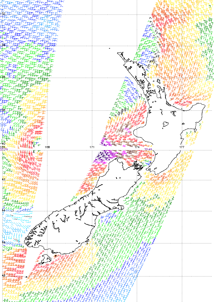
Our current combo of south and south-east swells are easing across the region and this will continue into Thursday. However, we’ve got a new pulse of E/SE swell of the cards, generated by a small, tight low pressure system that intensified off the West Coast of New Zealand on Tuesday morning (see ASCAT chart below, with core winds of 50kts).
This system didn’t last very long, and despite its strength the fetch length was relatively small, so I’m being cautious in my size estimates for Thursday - but I think the associated swell periods (Tp of 13-14 sec) should produce occasional 3ft+ sets at some exposed beaches (not all locations; these east swells have a habit of being patchy in their coverage). Note: this is bigger than our surf model is estimating (it often struggles with easterly swells originating from these kinds of systems).
Mixed in with the easing S’ly swell - of a similar size at south facing beaches early morning - this combo should produce some good waves across the coast. Just bear in mind that the bigger waves from the E/SE will be quite inconsistent. And just for good luck, there may be some small NE windswell in the mix from the freshening N/NE flow adjacent to the coast this evening.
Thursday's winds are however looking tricky. A developing low off the NSW coast will freshen N’ly winds overnight that should swing NW then W’ly relatively soon (very early morning), ahead of a gusty SW tending S’ly change. The timing on this change is as yet unsure even at just 24 hours out, the models are split between an arrival late morning afternoon or late afternoon (one model even having it in early evening) - but the take home message will be to surf early to capitalise on the best winds of the day.
If the change pushes through earlier than expected then we should see a late rapid increase in short range S’ly swell, but those locations picking up any of the size will also be wind affected. So it’s not worth worrying about (I don’t think we’ll see much before 5pm anyway).
As for Friday - the developing low off the coast looks like it’ll intensify quickly but concurrently track eastwards, resulting in an overnight peak that’ll trend steadily downwards throughout the day. South facing beaches should see sets in the 6ft range early (bigger in the Hunter) with smaller 3-4ft waves at remaining open beaches, and easing wave heights into the afternoon.
I also expect we’ll be under a southerly airstream for much of the day, so don’t expect conditions to be very good at most open beaches (especially the Hunter). There’s a chance for an isolated region of brief early SW winds (mainly the Northern Beaches) and the southerly flow will certainly ease in strength during the day, but for the most part expect bumpy conditions across the region.
This weekend (Sep 5 - 6)
The weekend’s looking to see a mix of southerly swells across Southern NSW. Friday’s south swell won’t last long, and will quickly trend down through Saturday but a small mid range swell is expected to maintain 2-3ft+ sets at south facing beaches, originating from a series of moderate polar fronts tracking well south of the Tasman Sea tonight and tomorrow.
A second south swell is due on Sunday, which will originate from the merger between a polar front and a mid-latitude low, just S/SE of Tasmania during Friday. This should provide the same, if not a smidge more size than Saturday’s south swell however both have been downgraded since Monday’s notes. Expect smaller waves away from south facing beaches (although the Hunter may see a few bigger bombs).
As for local winds, most models maintain a dominant ridge of high pressure across the region which suggests we’ll see light variable winds and afternoon sea breezes both days. But I’ll have more info on this in Friday’s update.
Next week (Sep 7 onwards)
More of the same for next week. Most computer model guidance suggests a cute off low will push across Tasmania early in the week, leading to a renewed short range south swell early-mid week, and possibly a short range NE swell just prior (around Monday). But, specifics are a little hazy at this early stage so we need a few more days to firm things up. Stay tuned to Friday’s notes for more information.
Comments
Still chunky at Bondi! Looks like winds are just starting to swing too.
And for those wondering why it's so abnormally warm off the Sydney region, here's another chart showing 20deg water pushing down from the East Australian Current.
Very unseasonal!
Much easier to see the E/SE angle at Bondi today, pushing more down the beach to the south than usual. 'Tis completely flat between sets though - almost feels like the south swell has completely gone now and we're left with the east swell (NE windswell isn't getting in here).
.. yet the Sydney buoy is locked in to the S/SE. No sign of any E/SE swell, just a tiny slither of E/NE swell.
Hmmm....
I'm also pleased with my Tp estimation. Model data had just 11-12 seconds, but with the ASCAT readings showing 50kts I knew it'd be higher. In the notes above I wrote: "I think the associated swell periods (Tp of 13-14 sec) should produce occasional 3ft+ sets at some exposed beaches".
MHL buoy recorded Tp of 13.82 seconds on the leading edge at 2am.
blew westerly throughout most of the middle of the day today and there were a few high tide banks around. gold!