Plenty of swell in store

Sydney, Hunter and Illawarra Surf Forecast by Ben Matson (issued Wednesday 17th December)
Best Days: Late Thurs/early Fri: another slightly stronger E'ly swell, with NE winds Thurs tending gusty S'ly early Fri. Sat: clean, peaky leftovers early morning with good winds.
Recap: A good mix of E’ly, then building NE windswell (accompanied by gusty afternoon NE winds) padded out Tuesday. We’ve seen gusty S’ly winds today with the same combo of E’ly and NE swells early, with a building S’ly swell throughout the day/. Hard to find clean conditions though as fresh S’ly winds swing SE and moderate slowly.
This week (Dec 18th - 19th)
Nothing amazing expected for Thursday. We’ll see a peaky leftover mix of easing S’ly swell, plus some residual E’ly swell from the same source that generated yesterday’s and today’s waves. Wave heights should manage 2ft+ at most beaches, down a smidge on today.
Winds are expected to freshen from the NE all day Thursday - there’s a chance for a brief period of lighter N’ly winds at dawn, but with overnight winds expected to be mainly light to moderate onshore, there’ll be some lumpiness on the surface (ideally, we need a few hours of moderate+ NW winds to iron out the bumps, and this isn’t likely). So expect surface conditions to be below par.
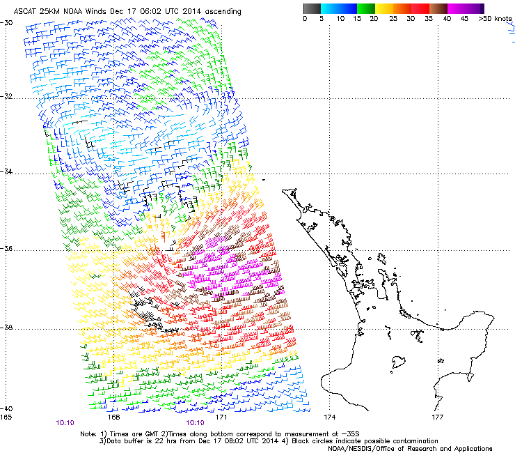
Very late in the day we’ll see the arrival of yet another pulse of E’ly groundswell, generated by an intensification of the stationary E’ly fetch (late Tuesday) that’s been positioned off the West Coast of New Zealand’s North Island since the weekend. The latest ASCAT satellite returns were impressive from this system, showing core wind speeds of 40kts aimed in a reasonable trajectory towards the southern NSW coast (see image below).
However, this fetch is both slipping southwards (not good for us) in addition to a counter-clockwise rotation of the fetch alignment (also not good for us), which reduces the surf potential from what would have otherwise been an excellent swell producer.
Furthermore, without the availability of offshore buoy data (and by ‘offshore’ I mean a couple of hundred kilometres east of the mainland, which would give five to eight hours notice of incoming east swells), it’s very hard to have confidence in the precise timing of the leading edge. Model guidance has it in late afternoon/early evening (around 6pm) but we need a few hours of elasticity on this (of which, wave heights rarely jump to their full potential within a few hours of the leading edge anyway).
What this means is that this swell event is likely to peak in size overnight Thursday. Friday morning will be your best time to capitalise on the biggest waves from this source (during daylight hours, that is!), of which I’m expecting 3-4ft at open beaches for the early session - maybe some bigger bombs south of Sydney, as the fetch is better aligned for the South Coast - but with an easing trend during the day. We could be down to 2-3ft by late morning with possibly even smaller surf by late afternoon.
As for Friday’s winds: we’re expecting a gusty change within a couple of hours before dawn (in Sydney), very similar to what we experienced this morning. This will effectively wipe out most open beaches so you’ll have to hunt for some protection from the wind. The southerly airstream will however ease in strength through the afternoon, and south facing beaches should pick up a bumpy short range S’ly swell to 3ft that’ll counteract the easing E’ly swell.
So there’ll be waves just about everywhere on Friday, but keep your expectations pegged a little lower than usual.
This weekend (Dec 20th - 21st)
Nothing of major interest this weekend. The models have marginally strengthened the trailing southerly fetch behind Friday’s change, so we’ll see a little more size on Saturday than was suggested in Monday's notes - but the trend will be downwards all weekend (perhaps some 2-3ft sets at south facing beaches early morning if we’re super lucky, but smaller through the afternoon).
There’ll probably be some small residual east swell in the mix but not much more than a foot or two.
As for winds - both days should see early light winds and sea breezes (SE Saturday, NE Sunday) but otherwise it’s all a bit lacklustre. I doubt Friday’s forecast update will move these particulars around much but it’s always worth double checking things.
Long term (Dec 22nd onwards)
Couple of things popping up on the long term model runs, which is encouraging.
Firstly, as mentioned on Monday we’ve got a broad trade belt developing north and north-east of New Zealand from this weekend onwards, signalling a return to small but long-lasting distant E’ly swell for the foreseeable future (beginning early-mid next week, that is).
A developing polar low well south of Tasmania late Friday/Saturday looks good on the synoptic charts, but as it’s a cut off system its swell generating potential needs to be curbed (for now). Current thinking is that we’ll get a fun shot of mid-range S’ly swell on Monday, with very inconsistent 2-3ft sets showing up at exposed south swell magnets (but unlikely to influence anywhere else).
Otherwise, we’ve got locally freshening NE winds form late Sunday thru’ Monday that’ll generate some windswell for the region on Monday, as a trough broadens over the SE corner of the country. Some models are now suggesting that this trough could push off the coast, evolving into a small Tasman Low during Tuesday - which could give rise to a punchy SE swell through the middle of the week.
Still along time away, but it’s fun to speculate on what might be as we work towards the Xmas period - especially as most of you will be on holidays, scouting for some great mid-week waves. I’ll update the specifics on Friday.
Comments
your forecast for this morning was bang on - but good thing I didn't pay any attention to the model forecast, really undershot the left over E swell.. was closer to 3ft
Thanks oiley, yeah some strong lines at Manly on the surfcam.
We've got a tweak for the surf model that should rectify the under-calling of these east (and also SE) groundswells.. we're pretty sure we know what's causing the issue. Will hopefully have a patch in the coming weeks.
thanks Ben - don't always see the yellow bars for east facing, more often than not the extra height is only added for SF
East facing beaches are 'open beaches' and are therefore represented with the green bars (the yellow bars only come into play if there is a notable difference in size at either South facing or NE facing beaches).
cool