Pulsey south swells in the short term; next week has promise

Sydney, Hunter and Illawarra Surf Forecast by Ben Matson (issued Wednesday 26th November)
Best Days: Friday: building south swell with light winds (prob onshore). May see a late NE trend so south facing beaches could offer fun late options. Saturday: early offshores and an easing south swell. Monday: building, inconsistent south swell with generally good winds. Tues thru' Thurs: potentially solid swell from the eastern quadrant.
Recap: Tuesday afternoon lived up to the ‘late arrival’ expectations, with a new south swell pulsing late in the day offering 3ft+ sets at south facing beaches, following on from a tiny morning. It faded this morning (2ft+ south facing) but a small NE windswell padded out remaining beaches. Unfortunately winds were mainly moderate onshore - against a forecast of ‘light and variable’ - so conditions were below par. Wave heights have subsequently eased this afternoon.
This week (Nov 27-28)
The next few days are still very tricky to pin down and/or have confidence in the surf outlook. The main problem is that our incoming energy has been sourced from a series of fronts that weren't particularly well aligned for the Australian East Coast. And local winds aren't going to play ball either.
Model data shows a new band of small, mid-period S’ly swell glancing the coast late today before peaking overnight and falling away steadily during Thursday morning. Another small glancing pulse is expected Thursday evening ahead of a more pronounced (read: better) increase in south swell for Friday.
Local winds look pretty poor on Thursday anyway, thanks to a front in the southern Tasman and a high pressure system in the eastern Bight driving a ridge across the NSW coast, resulting in fresh SE winds. So even if we see tonight’s south swell appear (it isn’t visible on the buoys or surf cams yet) and linger into Thursday, conditions will be pretty ordinary anyway.
Surface conditions look a little better for Friday but the ridge will still be the dominating feature across much of the NSW coast (especially in the north). We will certainly see an improvement across Sydney, Hunter and Illawarra coasts but I’m a little worried that land effects on Friday won’t be strong enough to override the modest synoptic flow, which is likely to be south-east, then tending north-east. At best we may see a few hours of light and variable winds early morning but I’m 50/50 on whether this will occur or not. Light variable winds are almost a certainty south of Wollongong though, due to a much weaker pressure gradient here.
Friday’s surf will definitely be on the upswing during the day though, thanks to two sources - a rapidly eastwards tracking front embedded in the westerly belt through the southern Tasman Sea on Thursday, and another swell with more S/SE in its direction, originating from the stalled parent low well to the SW of New Zealand’s South Island yesterday.
We may not see the bulk energy into Sydney beaches at dawn but it should be showing reasonably well by mid-late morning, and through mid-late afternoon should reach 3ft+ at exposed south facing beaches (with a few bigger sets in the Hunter). Hopefully local winds will remain light, so that by the time we see a late afternoon nor’easter, those handful of south-facing beaches that enjoy the south-swell-nor’east-wind-combo will provide some good waves for the evening session.
This weekend (Nov 29-30)
Saturday morning is the pick of the weekend. Friday’s late peaking south swell will be slowly easing but south facing beaches should see early 3ft sets with light NW winds (except a few bigger bombs in the Hunter). However, beaches not open to the south will be smaller, and winds will freshen from the north-east from late morning onwards.
On Sunday we’ll see mainly small peaky residual swell from the south and north-east (1-2ft, bigger in the Hunter) with freshening NE winds. A small long period south swell may arrive very late in the day - offering some stray 2ft+ sets to south facing beaches (again, bigger in the Hunter) but I am not yet sure whether it’ll arrive before sundown. More on this in Friday’s update.
Long term (Dec 1st onwards)
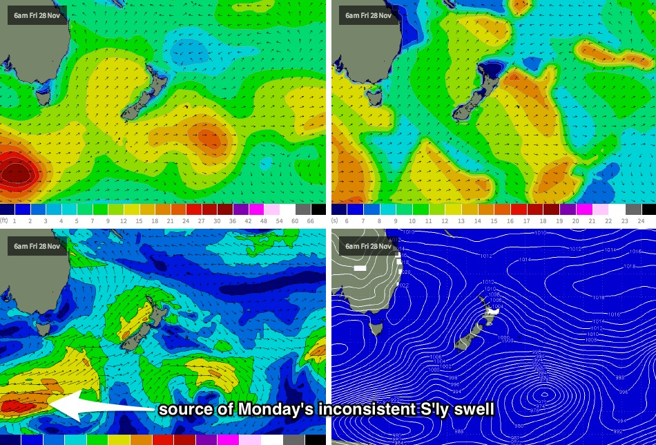
Sunday’s late long period south swell will be a precursor to a slightly bigger, better south swell due Monday originating from the same intense polar low that’s modelled to deepen well south of the continent on Thursday and Friday (see chart below). This system looks unreal on the synoptic charts but it’s expected to develop a very long way from the mainland, so set waves will be very, very inconsistent.
At this stage south facing beaches could see 2-3ft+ waves at times, and winds look to be variable under a troughy pattern. However, I really need to emphasise just how inconsistent this swell will be - you'll need to be extremely patient for the sets. Surf size will then ease slowly from Tuesday.
Also in the mix early next week will be a small level of NE windswell. But of much greater interest is the aforementioned coastal trough, which isn’t showing much on the long range synoptic charts but could very well evolve into a dynamic system capable of producing some sizeable short range energy from the eastern quadrant through the middle of next week (Tues to Thurs). More on this in Friday’s update with the availability of the latest model guidance.
Comments
Thermal Ben, enough with the teasing of east swells......there's certain spots here that haven't broken properly in over 6 months due to the lack of proper east or north east swells
hi guys what time does new friday report come out cheers
Late this afternoon, around 5pm.
Couple of lines starting to appear at Bondi now, looks to be 2ft to almost 3ft.