Large south swell on the way

Sydney, Hunter and Illawarra Surf Forecast by Ben Matson (issued Monday 29th September)
Best Days: Thursday: fun easing south swell with early offshore winds. Friday: building S'ly swell, large late a'noon. Saturday: large, easing S'ly swell with NW tending NE winds. Sunday: moderate, easing S'ly swell with NW tending NE winds.
Recap: There were a few small waves around the traps early Saturday before moderate to fresh southerly winds kicked in mid-morning. Set waves managed 2-3ft across most south facing beaches for the early session, falling away to about 2ft on Sunday as early light winds gave way to a freshening northerly breeze. These winds whipped up a small NE windswell for the late afternoon that persisted through into this morning, although very small in size (just a foot or two at exposed beaches, and very weak, and hardly anything in the Hunter). Winds have been out of the north all day.
This week (Sep 30 - Oct 3)
On Friday I outright dismissed a small E/SE swell that had been projected for Tuesday, from a fetch that was expected to develop in the eastern Tasman Sea on Sunday. Although the models had indeed downgraded the low expected to generate the new energy, it seems my write-off may have been a little premature.
The small low that formed in the central Tasman on Friday tracked east towards New Zealand over the weekend as modelled, however a minor SE fetch did eventually develop west of Cook Strait (the body of water separating the North and South Islands) on Sunday. Although I’m still confident we won’t see anything great from this source, we should see small infrequent waves arriving through Tuesday afternoon and (more likely) Wednesday morning. Don’t expect much more than 1-2ft at open beaches, and be prepared for very long breaks between waves.
Otherwise, anticipate tiny residual NE wind waves across exposed beaches throughout Tuesday (with an accompanying northerly wind). Wednesday morning should see a little more schtick in the NE windswell on (thanks to Tuesday afternoon’s strengthening nor'easter) however surf size is still not expected to be very large - perhaps 1-2ft+ at exposed NE facing beaches, which will hopefully tie in nicely with the small long range E/SE swell.
But Wednesday’s curveball comes in the form of a gusty SW tending S’ly change due very early in the morning - probably before dawn on the South Coast, but into the Sydney region within an hour or so of dawn.
Winds will veer more southerly from about lunchtime onwards, and should kick up a strong punchy southerly swell for exposed south facing beaches by the end of the day (between 3ft and possibly 5ft). However the initial low period and acute S/SW swell direction will limit size at protected locations.
Therefore your Wednesday options will be a small NE swell with fresh offshores early morning or a sizey but bumpy S’ly swell late afternoon.
Thursday looks fun with a slowly easing south swell and mainly offshore winds as Wednesday’s front retreats into the Tasman Sea. South facing beaches will be biggest at dawn (3-4ft+ sets, easing) however again it’ll be much smaller at beaches not open to the south. We may even see a sea breeze in the afternoon so get in early for the best conditions.
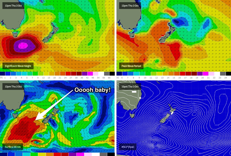
Friday is where the juice really starts to line up. By now you’ve probably read the article about the impending swell for Fiji ("Cloudbreak forecast to come out of the sky") - well, the same swell is going to hit Sydney a few days prior and we’re looking at an excellent, large long period south swell to finish the working week and kick start the weekend.
This south swell will be generated by an intense polar low tracking below the continent mid-week, which is expected to be steered up and into the Tasman Sea along a favourable N/NE route - right inside NSW’s prime south swell window. There are two features of this (forecast) system that are quite incredible right now: the strength of the surface winds - upwards of 50kts - and the sheer breadth of the fetch - spanning the entire southern Tasman Sea.
Initially there’ll be two swells in the mix - a short range south swell emanating from the top of the fetch (periods in the 10-11 second range), but the real power will originate from the core of the low and should generate peak swell periods of 18-20 seconds - not a common occurrence along the East Coast at all.
Surf size will be largest at south facing beaches, where we should see a steady upwards trend into the 6-8ft range by the end of the day (much smaller earlier tho'). Bigger waves are also possible at offshore swell magnets and up in the Hunter (10ft?). However beaches not open to the south will be smaller (late a’noon peak around 4-5ft) with smaller surf again inside protected southern corners (2-3ft).
Wind wise, it’s looking pretty good at this stage - a shallow southerly change is modelled to move along the southern NSW coast but at this stage I’m more inclined to think we’ll see light variable winds ands possibly an afternoon NE sea breeze. Let’s reassess the numbers on Wednesday.
This weekend (Oct 4-5)
Saturday looks to be a doozy at this stage. A large, easing long period south swell with light NW winds tending NE and freshening - perfect for a host of south facing beaches that enjoy these particulars. Early sets are likely to be in the 6-8ft range at the swell magnets (maybe bigger at offshore reefs and a handful of spots in the Hunter, near 8-10ft) however a steady easing trend is expected throughout the day. As per usual, beaches not open to the south will be much smaller.
Sunday’s shaping up to see the same trend (NW tending NE winds, easing size), albeit a couple of feet smaller. All in all a really good weekend for south facing beaches that like northerly winds.
Long term (Oct 6 onwards)
Nothing major on the charts at this stage, due to the Fri/Sat south swell occupying the focus of the latest model run. However I’ll have a closer look at the long term trend for next week on Wednesday.
Comments
Been a while since we've had a forecast like this, eh? Seems that way.
Yeah Ben.
Stash that one away in the archives.
IMO 10-15 years ago these systems used to develop in the winter months, as opposed to spring October...?
Its a funny old world we live in;)
Have you any old archives regarding this exposure around October in comparison to say June-August at 10-15 years ago...?
Cheers
Hi Ben,
Any predictions on how the weekends swell will hit the far south coast? A bit smaller or same same?
Thanks!
Should be a similar size range - no reason for there to be much of a size discrepancy between the Sydney and South Coast (compared to what we see from fetches developing out of eastern Bass Strait or off the South Coast).
Epic thanks!
Another question for you Ben: Can you say something in regards to the consistency of the sets on saturday? Sometimes you comment that the distance of the source results in long waits. How will this swell rate? Trying to suss out whether to go for the more or the less crowded spot :)
Ben thanks for the update . Ben our main problem being a northern beaches local is that any direct sth swell rights off from manly to palm beach . So basically it's just crap surf as soon as we all hear its south swell
I hear ya Peter. But there'll be waves around, some spots should be very good. Better than a weekend of tiny surf and fresh easterly winds!
Otherwise, hit the highway for a road trip. I'll be pumping across many parts of the state.
Why does the northern beaches hate south swells so much? 90% of the time we see straight closouts. I realise that south swells are running more parallel to the coast but that should result in less closeouts. Why do the sandbanks love east and north east swells but hate souths?
Good question.. I don't know the answer to that.
Not sure if this is the exact reason eel but I believe it's because our (northern) beaches predominantly face east or north east in direction but I could be wrong......someone like Nick/Tom Carroll would probably know
Here's that small E/SE groundswell (Sydney buoy picked up leading edge at 15 seconds). Shame the winds are up from the N/NE.
stop showing secret spots Ben!
Ha! Wait 'till you see our new surfcam at Cactus.
There were fun waves at middle narra from about 4pm with offshore winds. That long range east swell you forecast def arrived
Unreal! Thanks for the confirmation.
Mate the locals there will eat you alive....... literally ;)
Ben, the isobaric chart looks epic. 10-12 foot at magnets for sure.
I'm curious as to why your model isn't showing the swell to its full potential. Take a look at Cronulla for sat: 1.6m, 179deg@14 sec = 4ft.
Rusty, the wave model is moving around a lot with each update.. will take another day to come into line properly (however these S/SW swells are sometimes not picked up very well by the models). So, the problem lies in the WaveWatch model, not our internal surf forecasting model (which uses the wave model as input data). It'll be a lot bigger than 1.6m on Saturday, that's for sure.
This 'under-forecasting' is happening across most other sites too. For example, I just checked MSW and their Cronulla forecast for Saturday is 3-5ft (6ft @ 16sec).. and they forecast FACE feet! So their forecast is only waist to head high, whereas our 4ft is a foot overhead - much bigger (also, our Cronulla forecast is a little smaller due to the directional algorithm - the Northern Beaches forecast is currently 4-5ft).
An update for ya Rusty - the models have upgraded the system again this morning - currently calling 6ft at Cronulla's south facing beaches at midday Saturday (that's double overhead), as per the screen shot below (2.1m @ 15.8 sec, dead south 180 degrees).
Interestingly the models have actually combined two swells for the lunchtime forecast - the 6am time step has 1.8m @ 18.5 sec from 185 deg, and 1.5m @ 10.7 sec from 178 deg.
[and for the record, MSW's model has also upgraded from yesterday's 3-5ft Cronulla forecast to 4-6ft, so that's now chest to head high.. around half of our forecast]
Unfortunately, we don't have any control of how the wave model model splits the swell trains in this regard. And our 'surf height' forecast uses only the primary swell train for the initial size, and the secondary swell train if there's a significant directional variation between individual trains. However we're looking to create a method that assess all swell trains as a whole (over many time steps), and identifies when they've split or joined - in which we'd then like to compensate the 'surf height' forecast as a result.
Short version: we've got a few tweaks to the model coming up :)
Dont worry there is no waves in Cronulla worth surfing anyway. No where to surf
in a south swell and north winds at Cronulla.
Cronulla works on a west swell and east winds.
You should know that rusty-moran!!!
That small E/SE swell is still kicking along nicely this morning, despite howling offshore winds.
All over now Ben, but there was a brief window there, the wind dropped off a bit and the swell kicked a little. Nothing spectacular but better than expected!
If you are thinking about coming South Coast, my stretch is Stanwell to Kiama and we have the worst sand banks in years.... Not sure what the go is but it's been the worst shape banks ever. Went from too much sand, super hollow hectic close outs in the pre- winter to none at the moment with a number of spots that tend to slab onto sand in front of rocks not even breaking. low tide looks like high tide banks at most spots during the 2 - 6ft we have had over the last couple of months..... Fat and fading out. The reefs and points have been packed and each of then has a tight crew that own it, I tend to surf the beaches cause I hate the 30mins wait on reefs and points. I don't have time, I got 3 kids, a wife and 2dogs that want me home!
There has been a spike in online media and print media focused further south, where we don't name spots and I reckon that's where to be!
that's not south coast!
I'll be finding myself south of Ulladulla! yeww
ACB, I have no doubt that there will be awesome waves down South that way.... Where we don't name spots. I got broken nuts at the moment and am on the sidelines or I would up at 3am tomorrow to get down to you for the early and make it home by 11 am ....
Oh man I'm shaking with excitement... making the 5 hour drive tonight!
I hope for a speedy recovery on your nether regions.
Looking at cronulla now I don't see any signs of coming swell. 1400hrs
Settle Popout, don't peak too early.
I'm gonna be at the big V tomorrow morning if you're around.
The main swell is due in later today (peaking tomorrow).
I will be around. But there are no waves in the shire. The world knows that.
Any word of anything hitting the south coast Batemans, Ulladulla yet?
5ft lumpy sets at headlands... 2ft beachies...