Upgrade in SW groundswell due late week

Southern Tasmania Surf Forecast by Craig Brokensha (issued Wednesday 19th September)
Best Days: Thursday morning, Friday from late morning, Saturday morning, early Monday, protected spots mid-next week
Recap
Tiny surf yesterday morning, but a new W/SW groundswell kicked into the mid-late afternoon as winds remained offshore. The swell should of held well into this morning but is on the ease.
Today’s Forecaster Notes are brought to you by Rip Curl
This week and weekend (Sep 20 - 23)
Our current W/SW groundswell should continue to ease through tomorrow with dropping 1-2ft sets under a NW tending W/NW breeze.
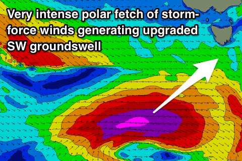
We've got an upgrade in the strong groundswell due late week across the state, with an intense polar low currently forming south of WA.
We'll see a great fetch of severe-gale to storm-force W'ly winds projected east for over 24hours in our south-western swell window, producing a large long-period SW groundswell that's due to arrive Friday morning and build rapidly through the afternoon.
Clifton should kick to an easy 4ft before close of play and with a N/NW tending W/NW breeze.
 The swell will peak through the evening and drop fairly quickly Saturday from 2ft to maybe 3ft if we're lucky with great offshore NW winds ahead of a gusty W/SW change during the middle of the day.
This change will signal the first in a series of strong polar fronts pushing through our swell window and up towards the Tasman Sea under the influence of the Long Wave Trough.
This first front will generate a good fetch of strong to gale-force W/SW winds through our our western swell window Friday and Saturday, passing under us Sunday.
We're looking at sets developing to a consistent 3ft through the day Sunday but with generally average winds from the W/SW tending SW as the front passes under us.
The swell is due to drop temporarily through Monday from 3ft with an early W/NW'ly, but a much stronger and slower moving polar storm will develop south of us, projecting a fetch of initial SW gales through our swell window, followed by severe-gale S/SW winds on Tuesday.
A large and powerful S/SW groundswell will be generated, building Tuesday and peaking Wednesday morning. Winds will be strong from the SW, favouring protected locations, but we'll have a closer look at this Friday.
Comments
Satellite verification is quite impressive!
Awh i knew next week was too good to be true ): the ascending barbs are pretty west for tomorrow .. hopefully it gets in !! thanks craig
Yeah bummer, was all in alignment and all shifted a bit more east..