Good S/SW swell late week with more size from Sunday

Southern Tasmania Surf Forecast by Craig Brokensha (issued Monday 13th August)
Best Days: Beginners Tuesday, Thursday, Friday, Monday
Recap
Tiny surf Saturday and Sunday morning before some new W/SW swell kicked into the afternoon, though dropping back from a reported tiny 1-1.5ft
This week and weekend (Aug 14 - 19)
Today’s Forecaster Notes are brought to you by Rip Curl
The small pulse of W/SW swell seen yesterday afternoon and this morning will fade into tomorrow, but a strong front passing under us today, generating W'ly gales looks to produce a tiny 1ft of W/SW swell for tomorrow with W/NW tending NW winds.
This is then due to fade through Wednesday with the next increase in size due through Thursday and Friday.
A vigorous mid-latitude low will move in from the west and dip south-east across us on Wednesday but winds will be W/NW in direction with no new swell expected through the day.
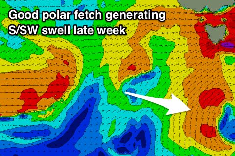 A better aligned polar fetch of S/SW winds is expected to develop south of us on Wednesday, generating a new S/SW swell that should build later Thursday and peak Friday.
Some small weak mid-period W/SW swell will also be in the mix from the backside of the mid-latitude low pushing across us Thursday.
This should provide 2ft sets on Thursday with the S/SW energy possible kicking a little larger late in the day, peaking Friday to 2ft to nearly 3ft.
Winds on Thursday look good through the morning with a W/NW breeze possibly swinging W/SW temporarily before tending back W/NW later and then holding all day Friday from the NW.
A low point in swell is expected early Saturday but through the day and more so into Sunday and Monday, a strengthening and slow moving polar front is expected to develop across the state, bringing strong to near gale-force S/SW winds.
This fetch will extend well south of us but without too much strength, resulting in a building S/SW windswell Saturday afternoon as it pushes across us, increasing further Sunday as a better fetch of S/SW winds are projected into us.
Winds will be onshore but the size likely reaching 3-4ft later Sunday and easing Monday with much cleaner conditions. We'll have a closer look at this on Wednesday though.
Comments
Hey why isn't BoM and the automated models picking up this Friday S/SW swell ? Super weird can't find it anywhere other than wams. Is it because it's outside of their grid extents ? Or is it not happening anymore ?
Cheers !!
Yeah it's not being resolved by the models, hence the worth of these forecast notes :)
Yew cheers ! Whats the time stamp on the winds you screenshotted on WAMS ? Maybe it's changed but i can't find it. If you reckon it still looks good I might check scat before i set off on a full mish haha
Yeah models are still sticking with it, here's the last 18z forecast chart. Wednesday evening..