Good swell mid-week, larger into Thursday/Friday

Southern Tasmania Forecast (issued Monday 29th September)
Best Days: Later Tuesday, Wednesday at periods, early Thursday, Friday in protected spots, Saturday morning
Recap
Saturday was small and fun across Clifton with an easing swell from Friday under warmish offshore winds. Sunday was tiny but still clean and this morning the same with a tiny acute W'ly swell.
This week (Sep 30 – Oct 3 )
At the current moment a good sized but really acute W'ly swell is pushing past us, generated in the Bight over the weekend.
A much better alined secondary frontal system is now pushing in from under WA towards us with a fetch of W/SW gales being generated in our western swell window.
This should produce a moderate sized W/SW groundswell building later tomorrow and peaking Wednesday morning.
We should see 2-3ft sets developing later tomorrow under fresh N/NW winds ahead of a W'ly change that may swing W/NW late in the day.
Wednesday should see 3ft+ waves all day but winds may be an issued with an early morning SW change likely to linger across the coast.
There's a good chance for an early W/NW'ly though and then a swing back to the W/NW late afternoon as well, so these are the times to hunt around for a wave.
Things become real interesting into Thursday and more so Friday as a vigorous polar low that was swinging in and out of favour by the major forecast models now expected to fire up in a big way below the state.
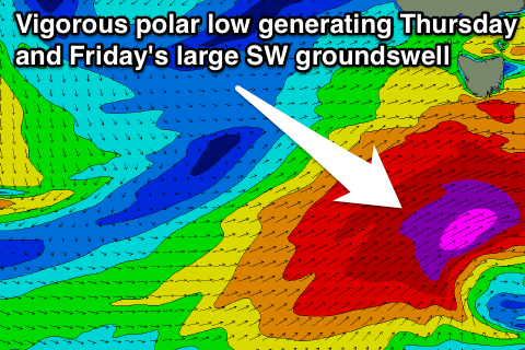 A strong node (peak) of the Long Wave Trough will move across us and over the Southern Tasman Sea on Wednesday and with this we'll see a vigorous polar low steered and strengthened from below us, straight up towards New Zealand and through our south-western swell window.
A fetch of severe-gale to storm-force SW winds will be directed up through our swell window, generating a large SW groundswell that should build Thursday and peak Friday morning (pushing onto Cloudbreak for Monday).
Clifton should reach 4-6ft later in the day Thursday and then peak early Friday to 5-6ft before dropping steadily during the day, down to 3-4ft by the afternoon.
Winds will be the main issue and offshore early Thursday from the W/NW ahead of a gusty SW change through the morning.
Friday will then see lingering onshore SW winds that will improve and swing straighter W'ly during the day favouring protected locations early and more exposed coasts later.
This weekend onwards (Oct 4 onwards)
The swell will continue to drop away steadily through Saturday from 2-3ft during the morning down to 1-2ft through the afternoon under fresh N/NW winds.
Longer term there's nothing major on the cards at all so try and plan around the coming week of waves and check back here Wednesday for an update on the outlook for Thursday/Friday.
Comments
Craig...... This "cloudbreak swell"...... Any chance some of the usually dormant Tassie points may fire up, not just Hobart, but where the "cheer cheer the red and the white" sit by the seaside?
Haha, nice work, I'd say with that period there should be some nice lines wrapping in to selected points. Best in S/SE swell as you know, but there should be waves.
Well that means there will be waves down at my place too..... Cheers, man.....