Plenty of swell ahead, but you'll have to work around the winds

South-east Queensland and Northern NSW Surf Forecast by Ben Matson (issued Monday 24th September)
Best Days: Wed/Thurs AM: fun S'ly swell, becoming solid across Northern NSW on Thurs though the a'noon will be tainted by NE winds. Only small in SE Qld on Wed, but fun waves at exposed northern ends. Outer points potential early Thurs before the wind gets up.
Recap: Easterly swells built over the weekend, with later Saturday and Sunday producing inconsistent 2-3ft sets across many open coasts. Winds were out of the south on Saturday, favouring the points, whilst Sunday morning saw light winds ahead of a fresh NE afternoon sea breeze. Late Saturday and Sunday also saw some small long period S’ly swell across the coast, with a wide range in response in the size department, generally around the 3ft mark with size easing into this morning. Fresh southerly winds have pushed up the coast today creating small clean waves across the outer Gold Coast points up to an inconsistent 2ft+, but with little options elsewhere.

Plenty of swell on the Tweed this morning
This week (Sep 25 - 28)
Today’s Forecaster Notes are brought to you by Rip Curl
Tuesday looks a little ordinary overall, thanks to a ridge of high pressure pushing across the region and maintaining early fresh S/SE winds north from Yamba. They’ll ease through the day but the damage will be done at exposed beaches, especially in Far Northern NSW (we’ll see a more rapid improvement across the Mid North Coast though).
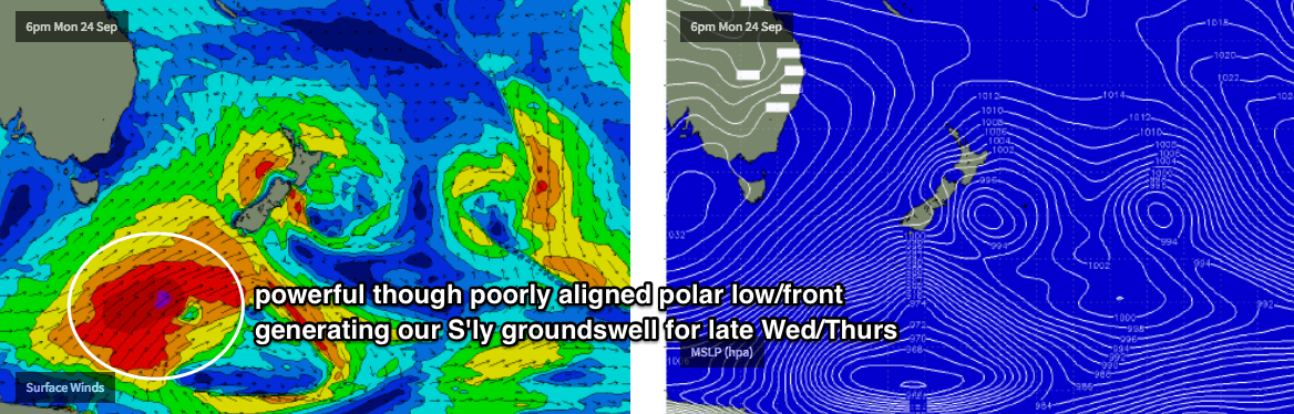
As for wave heights, we’ve got a multitude of small swell sources inbound (long range E’ly, short range S/SE) but the most dominant swell trains over the coming days will be a series of overlapping southerly swells generated by strong, though poorly aligned frontal activity through the Southern Tasman Sea.
This will build wave heights to 3ft+ across Northern NSW’s south facing beaches (south of Byron) during Tuesday, however the direction will result in very small surf across most of SE Qld, away from the exposed northern ends (and they’ll be quite bumpy). Small peelers are likely at the outer points but it’s not worth too much attention.
Fortunately, winds will tend light and variable into Wednesday and early Thursday as a ridge of high pressure moves into the Tasman Sea. Wednesday will see similar wave heights as per Tuesday afternoon's increase, though around lunchtime we’ll see the leading edge of a new long period swell push across the Mid North Coast, reaching Far Northern NSW late in the day, and building more prominently into Thursday morning - likely peaking across all coasts throughout the middle of the day.
This swell will have been sourced from an impressive polar low pushing up towards New Zealand late Monday and through Tuesday (see below), and although not perfectly aligned within our swell window, should provide some significant size at south facing beaches south of Byron, thanks to the broad, lengthy and sustained fetch - sets should push up into the 5-6ft range, with bigger bombs at a handful of reliable south swell magnets.
The only downer is that winds are expected to swing to the north and freshen through Thursday, just as the swell reaches a peak. We’ll see a period of light NW winds early morning, but this may not coincide with the peak surf size. Wednesday should see favourable winds for most of the day (with smaller size) though there is also the risk of an afternoon sea breeze from the north-east.
As for SE Qld, this system won’t be very well aligned but the impressive swell periods should allow for a considerable wrap back into the coast. We’re likely to see occasional 2-3ft+ sets across the outer points: with some luck we’ll see that size start to show through the morning before the nor’easter crops up. Expect bigger surf at exposed northern ends, though there will be long breaks between the bigger waves.
Rapidly easing southerly groundswell is then expected into Friday, from 3-4ft+ to 2-3ft at south facing beaches south of Byron, with smaller surf elsewhere. Wave heights will probably be half this across SE Qld, but it’s a moot point anyway as we’re looking at northerly winds gusting 20-30kts during the day (probably building 2-3ft of NE windswell by late afternoon).
So, don’t worry too much about Tuesday, aim for Wednesday and early Thursday, and flag Friday. There’s your week in a nutshell.
This weekend (Sep 29 - 30)
The weekend looks pretty average.
Friday’s northerly winds may leave us with some local NE windswell, but the fetch will ease overnight so the trend will be downwards (and, it’ll only be a weak short range event anyway).
Otherwise, a surface trough will push off the Southern NSW coast overnight into Friday, and a return southerly flow developing in its wake will build a local southerly windswell into Sunday with sets around 2-3ft at south facing beaches south of Byron. Winds will probably veer S/SE anyway as another trough slide up the NSW coast and into the Coral Sea.
We’ll also see a small southerly groundswell push through from a poorly aligned front south of Tasmania on Friday, but it’s not worth worrying about.
Also, all weekend will see some small, distant E’ly swell from a subtropical low way out near Tahiti, but it’s too far away (and too small in size) to generate anything notable in the surf department.
Next week (Oct 1 onwards)
Just the usual Southern Ocean frontal progression and associated south swell potential for next week - nothing significant but enough to keep a close eye on. Otherwise, the trades look like they’ll get quite active through the long term period, increasing our easterly swell potential.
More on all of this in Wednesday’s notes!
Comments
The world would be a better place if there were more dbahs
Good waves on the back beaches this morning, offshore and scored a solid hour plus when the crowd disappeared.