Another week of small flukey south swells; next week looks rather exciting

South-east Queensland and Northern NSW Surf Forecast by Ben Matson (issued Monday 30th July)
Best Days: Tues - Fri: small south swell at swell magnets south of Byron. Mon onwards: building E'ly groundswell, towards a peak mid week.
Recap: Saturday came in a little better than expected across Northern NSW, with light winds and very inconsistent but fun 2ft+ sets from a long range south swell. Much smaller surf padded out Sunday and today. It’s been tiny for quite some time in SE Qld.
This week (July 31 - Aug 3)
Today’s Forecaster Notes are brought to you by Rip Curl
Over the weekend I downgraded expectations for the upcoming south swell for Northern NSW on Tues/Wed, though not because the low/front has lost strength - the swell source being a broad system that crossed the Tasmanian divide overnight, with two fetches expected to contribute swell over the coming 24 hours.
By way of example, check out Hogan Island, which lies immediately E/SE of Wilsons Promontory, upstream from my frequently discussed flukey-south-swell-source-region of Eastern Bass Strait.
Overnight, westerly winds averaged 61kts (121km/hr) or greater from 8:24pm until midnight, with maximum wind gusts reaching 81kts around 11:30pm.
That's 150km/hr.
It’s worth pointing out that the Beaufort scale’s twelve point rating system has Hurricane strength at the top of the list, which is when average winds are greater than 64kts. As such, Hogan Island experienced Hurricane-strength conditions for two consecutive hours. It’s the equivalent of a Category 5 Tropical Cyclone.
But, this is a moot point as it relates to Northern NSW’s surf potential, because the main requirement for fetches exiting Eastern Bass Strait is that they display at least a whisker of south in their orientation. Alas, winds remained W’ly all night (and all day today), in fact veering W/NW this afternoon. And this has a major bearing on whether we’ll see much energy in the surf zone across Northern (and also Southern) NSW.
We have seen some small long period swell glance the Southern NSW coast this afternoon with sets now reaching 2ft across Sydney’s south facing beaches late in the day, but to be frank, I’m not particularly confident on how much size we’ll see across Northern NSW. Hurricane-force system or not, it simply has to be pointed at least partially towards our coast to be of benefit. A weaker secondary fetch rounding the Tasmanian corner this morning will contribute some background energy over the coming days but it too had its orientation tweaked over the weekend by the models.
So in short, I’m not confident on size prospects for Tuesday. I’ll go with extremely slow, inconsistent 2-3ft sets across south facing beaches south of Byron (probably undersized early morning in the Far North), with tiny surf elsewhere and also throughout SE Qld - maybe some stray 1.5ft sets at the exposed northern end of the Gold Coast later Tues/early Wed.
A series of similarly zonal fronts (aligned west-east) will track through the same swell window on Tuesday and Wednesday, offering smaller levels of south swell into Thursday. At this stage south swell magnets south of Byron may pick up occasional 2ft+ sets, but it’ll be tiny elsewhere, once again including SE Qld.
We may see a smidge more substance in the south swell into Friday, thanks to the source of Thursday’s minor pulse stalling in the southern Tasman Sea, though we’ll concurrently see freshening northerly winds along the coast, which will restrict surfable options to sheltered northern corners.
So overall, Northern NSW surfers should make the most of Tues thru’ Thurs at south swell magnets. SE Qld surfers will have to hit the road in order to find anything remotely rideable, but it really won’t be worth the mileage.
This weekend (Aug 4 - 5)
Looks like a pretty ordinary weekend at this stage, with very small residual swells and light variable winds Saturday tending N’ly on Sunday and freshening.
A new surface trough developing north of New Zealand mid-late week may generate some small infrequent E’ly swell through the weekend (more like Sunday than Saturday) but right now it doesn’t look very promising.
Next week (Aug 6 onwards)
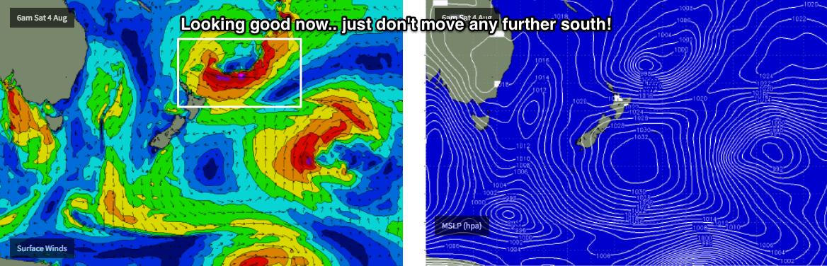
The models are showing some interesting developments north of New Zealand over the weekend. Later this week, a broad but initially weak trough will slowly gather strength and by the weekend could very well display some incredible winds around its eastern and southern flanks (see chart below).
At this stage model guidance suggests it’ll hover right on the periphery of our eastern swell window - current projections are good, but we don’t want it to slide any further south, and reside inside the swell shadow of New Zealand’s North Island.
As such, let’s cautiously peg in some building E’ly groundswell from Monday onwards, building towards a peak during the middle of next week. Model output right now suggests some serious size, but let’s pull it back for now (say, 3-5ft open beaches in SE Qld and Far Northern NSW) and then perhaps upgrade as the model guidance consolidates, and we draw a little closer to the event.
See you Wednesday!
Comments
Interesting trough systems you see the same patterns in rock formations shear zones and faults.
Coupla very small though straight lines of south swell getting into the northern end of the Goldy.
Swell is over-performing in Port, and the Crowdy buoy shows this well.
Good lines..
Yes a pleasant surprise down these parts this am :-)