Extended period of nought for SE Qld; small S'ly and SE swells for Northern NSW

South-east Queensland and Northern NSW Surf Forecast by Ben Matson (issued Monday 23rd July)
Best Days: Wed/Thurs: small SE then S'ly swells south of Byron with generally good winds. Not much in SE Qld. Sat: chance for a small peaky N'ly windswell.
Recap: A strong southerly swell built through Saturday, peaking Sunday with 4ft sets at south facing beaches south of Byron, and conditions were clean under a light offshore breeze. Unfortunately, not much size made it north of the border. Wave heights have eased slowly into today though are still maintaining occasional 3ft sets at south swell magnets south of Byron.
This week (July 24 - 27)
Today’s Forecaster Notes are brought to you by Rip Curl
We’re staring down the barrel of an extended period of winter mediocrity in SE Qld. I can’t see there being anything worthwhile for the rest of this week as our primary swell windows have been inactive of late.
Northern NSW however has a couple of small interesting swells to keep us active.
Tuesday will kick off similar to today, except with a little less size and freshening NW winds tending N’ly throughout the day. There won’t be much surf in SE Qld and only exposed south swell magnets south of Byron will pick up small peaky waves.
The low responsible for the weekend’s south swell stalled near New Zealand, and a broad southerly fetch on its western flank - whilst not aligned well for our coast - has generated a small new SE swell that’ll fill in over the coming days.
Model guidance has slowed this down since Friday’s estimates - we’re looking at the leading edge pushing through the Lower Mid North Coast later Tuesday afternoon, reaching remaining Northern NSW beaches Wednesday morning. There won’t be a lot of size on offer but inconsistent 2-3ft sets are likely at exposed beaches south from Byron, slightly smaller across the Tweed.
I can’t see most SE Qld beaches picking up much from this swell, but exposed northern ends of the Gold Coast (and to a lesser degree, the Sunshine Coast) may rake in the odd stray 2ft set. But it’s not worth working around.
Fortunately, Wednesday’s conditions look clean with light variable winds and afternoon sea breezes.
Also in the water on Wednesday - building slowly through the day - will be a small south swell from a vigorous front exiting eastern Bass Strait on Tuesday. The fetch will display a little more west than I’d prefer, but we should see occasional 2ft+ sets across south facing beaches south of Byron.
Otherwise, the second half of the week looks a little average but there’ll be a few small waves at exposed south swell magnets south of Byron. Wednesday’s SE swell will ease back into Thursday, but a series of poorly aligned fronts south of Tasmania from Tuesday onwards will maintain small levels of acute south swell on Thursday and Friday.
I’m doubtful most beaches will see much, if any action, but reliable south swell magnets south of Byron could see occasional 2ft+ sets if we’re super lucky. Thursday is the only workable day though as strengthening N’ly winds on Friday may become strong and gusty into the afternoon, rending even the most sheltered northern corners quite ordinary.
This weekend (July 28 - 29)
I’m not expecting much, if any south swell this weekend. Whatever energy makes landfall Thursday and Friday may hold out into Saturday, but only at reliable south swell magnets south of Byron, and even if this occurs I think the sets will be too slow and inconsistent to bother with.
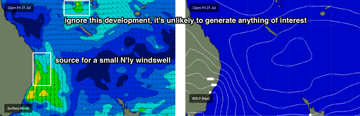
Saturday morning may however present an unusual N’ly windswell.
A developing trough over the eastern states later Friday will strengthen northerly winds along the coast and model guidance expects this will generate a short lived but peaky northerly windswell that could reach 2-3ft at some reliable north-facing beaches into Saturday.
Winds are expected too eventually veer NW, then W’ly as a trough pushes off the coast - possibly forming a small low off the South Coast - but it’s early days yet.
If we see the surface low form east of Bass Strait later Saturday, it may generate a south swell for Northern NSW on Sunday - though model guidance suggests this won’t be particularly strong nor long-lived (therefore, right now I’m not expecting much surf from it). So again, keep your expectations low for now.
Next week (July 30 onwards)
A strong cold front is expected to deliver gusty S/SW winds and building S’ly swells across the region early next week.
Also, I just thought I'd point out that some of the models are showing a small tropical system north of New Caledonia from Friday onwards (see chart above) - it's not worth worrying about at this stage, as it's too small, and positioned in an unfavourable environment, within a very flukey swell window, in the off-season for this part of our swell window.
Comments
What to do? No surf and no Bhargwan.
That new SE swell looking pretty nice in Coffs this AM.

Easy 2-3 down here and a nice direction with that touch of east in it.