Extended period of user-friendly south swell ahead

South-east Queensland and Northern NSW Surf Forecast by Ben Matson (issued Friday 20th July)
Best Days: Sat/Sun/Mon: fun south swell across Northern NSW. Tues: possible small SE swell. Wed PM/Thurs/Fri/Sat: small to moderate S'ly swells.
Recap: It’s been pretty small for the last few days, with minor southerly swells in Northern NSW Thursday and small northerly windswells today.
This weekend (July 21 - 22)
Today’s Forecaster Notes are brought to you by Rip Curl
We’ve got a bog standard south swell ahead for the weekend. However it’s only going to favour Northern NSW.
A cold front crossing the region today will swing into our south swell window overnight, and we’ll see building southerly swell through Saturday before wave heights peak early Sunday and then ease throughout the day.
Most south facing beaches south of Byron should pick up 3-4ft+ sets at the height of the swell (early Sunday), though it’ll be much smaller at beaches with less southerly exposure. SE Qld beaches won’t pick up this swell very well however some exposed northern ends (mainly Gold Coast) should see peaky 2ft+ waves early Sunday morning too. Expect much smaller surf elsewhere.
Also, expect a delay on the upwards phase of this swell in the Far North through Saturday. As such we’ll probably start the day with tiny leftover surf, north of about Yamba. It’ll build through the day though, mainly the afternoon.
Winds look OK both days though moderate SW tending S’ly winds are possible at some locations in Northern NSW on Saturday, so Sunday morning is a better bet with early offshores tending light to moderate S’ly throughout the day.
Next week (July 23 onwards)
The weekend’s south swell will ease through Monday. Light winds are expected early so south swell magnets south of Byron should see some small peaky waves in the 2-3ft range, smaller throughout the day. Don’t expect much size elsewhere.
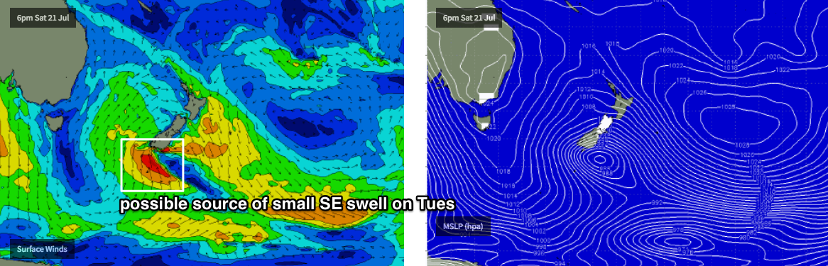
A minor SE swell is expected to fill into Northern NSW on Tuesday, sourced from a brief interaction between the current front (responsible for the weekend’s swells) sliding east through the Tasman Sea on Saturday, and a small polar low well south of New Zealand (see below).
This is expected to strengthen a S’ly fetch below New Zealand in the early hours of Sunday morning, however it won’t have enough length nor last long enough to generate any notable size. A handful of swell magnets may pick up some occasional 2ft, maybe 2-3ft sets if we’re lucky but in general we’ll push through the middle of the week with minor residual southerly swells. Freshening NW tending W’ly winds will keep the coast clean through this time as a series of vigorous fronts push through the Bight.
As these fronts exit eastern Bass Strait into the early hours of Wednesday morning with W/SW gales, we’ll see an acute south swell build across south swell magnets late Wednesday (Mid North Coast) and into Thursday. Early estimates are for 3-4ft sets at south facing beaches south of Byron, though I am again doubtful we’ll see much size across SE Qld.
Looking further ahead and more Southern Ocean fronts are expected maintain a consistent push into the lower Tasman Sea, which suggests an extended period of at least moderate plus south swell across Northern NSW through the end of next week and into the weekend too.
Have a great weekend, see you Monday!
Comments
Never will I find true fulfillment without a South swell magnet south of Byron
We all need to make sacrifices in our lives. So I think a surf industry CEO is the best offering we could make to appease the surf Gods .It should provide a decent swell. Only joking a boy band is the ultimate sacrifice and would appease for years.