Building southerly swell, small east swell, generally good winds

South-east Queensland and Northern NSW Surf Forecast by Ben Matson (issued Friday 13th July)
Best Days: Sat/Sun/Mon: small inconsistent E'ly swell in SE Qld, light winds. Sat PM/Sun AM: strong pulse of S'ly swell in Northern NSW, generally good winds. Mon: easing S'ly swell across Northern NSW.
Recap: Thursday saw slowly easing southerly swell across the region, with mainly light winds. Today delivered small waves throughout SE Qld with a minor increase in E’ly swell into the afternoon, whilst Northern NSW picked up a flukey south swell that was mentioned in Southern NSW’s notes (on Wednesday) but unfortunately omitted from these notes, due to the remote, low confidence source (a polar low skirting the ice shelf well south of Tasmania earlier this week). Set waves have been inconsistent, but occasionally pushing 3ft at exposed beaches, and it’s been clean with light winds.
Today’s Forecaster Notes are brought to you by Rip Curl
This weekend (July 14 - 15)
Want to receive an email when these Forecaster Notes are updated? Then log in here and update your preferences.
The weekend looks reasonably fun all round.
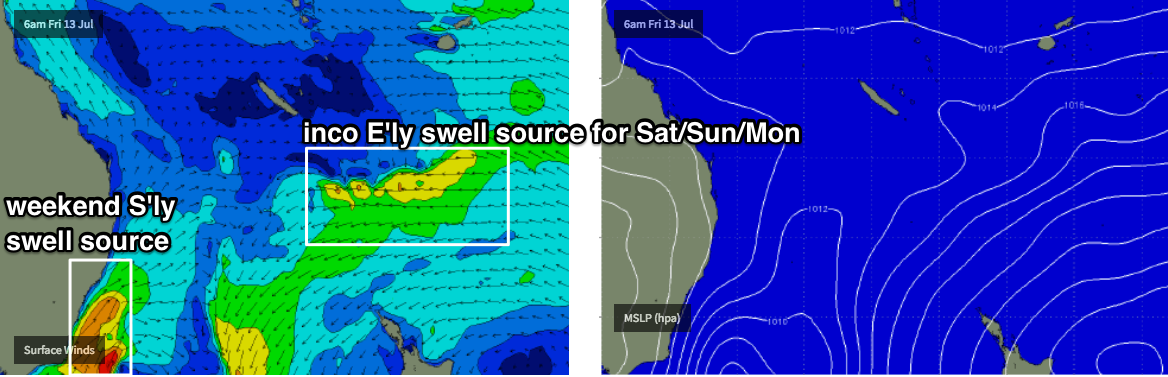
A ridge developed across the Northern Tasman Sea on Wednesday, and although it’s slowly tracking to the east, should provide some slow, inconsistent E’ly swell across SE Qld over the coming days.
We’ve got a very large tide cycle that’ll have some bearing on the consistency of the swell at times (reducing set frequency on the outgoing, swallowing up around high) but reliable swell magnets should see 2ft, almost 2-3ft sets at times - this is more than the models are estimating, but I think the slow moving nature of this fetch will tip the balance in our favour. Just aim for the wide open beaches as these kinds of slow swells are often troublesome at the outer points. Both days will be clean with light winds.
This small east swell won’t show very well south of about Ballina, but Northern NSW will otherwise pick up a strong new south swell from a new low pressure system developing off the Southern NSW coast today.
The models have pulled back the overall strength of this system (since Wednesday’s notes) so I’ve marginally pulled back size estimates but we should see south swell magnets south of Byron building to 5-6ft by late Saturday. There is a chance that the Far Northern NSW coast may not see this peak in size until overnight (such will the upward trend be focused towards the afternoon), and it'll be undersized early morning, though trending upwards across the Mid North Coast from early-mid morning onwards.
Also, it needs to be reiterated that this is a tricky system, mainly because of the angle of the fetch, which is more S/SW than usual. As mentioned in Wednesday’s notes: whilst I usually refer to these swells as being southerly in direction, the source fetch alignment means the energy needs to spread angularly back in order to reach the Northern NSW coast - which brings about a wider variety in size between exposed and protected locations, reduces the overall consistency and generally lowers the potential for anything amazing in the surf department. As such, expect much smaller waves away from south facing beaches, and consistency may not be very high either.
The low off Southern NSW is expected to undergo some changes into Saturday, forming a secondary S’ly fetch east of Tasmania that’ll provide a renewal of small south swell into the start of next week. A modest fetch between the two will somewhat arrest the easing trend into Sunday, with south facing beaches again seeing the most energy, with early 4ft+ sets easing slightly into the afternoon. Again, it’ll be much smaller at beaches with less southerly exposure. Conditions should be great with mainly light offshore tending variable winds.
This south swell won’t provide much size north of the border, although south swell magnets and exposed northern ends of the Gold (and maybe Sunshine) Coasts should see occasional 2-3ft+ sets either very late Saturday or (more likely) early Sunday morning.
Winds should be pretty good all weekend across Northern NSW, mainly moderate offshore on Saturday tending variable into the afternoon and through Sunday.
Next week (July 16 onwards)
Monday looks pretty fun, with light offshore winds and a mix of southerly swells from the bottom of the low providing inconsistent 2-3ft+ sets across south facing beaches south of Byron Bay (smaller elsewhere). The weekend’s small inconsistent east swell will likely persist at a similar size range throughout SE Qld, though it’s not a very strong source. Light offshore winds will continue throughout. Size will ease from these sources through Tuesday.
The rest of the forecast period looks a little nondescript, despite a cursory glance at the Tasman synoptics suggesting otherwise.
As mentioned on Wednesday, the developing low off the South Coast is part of a much broader surface trough encompassing the entire Tasman Sea.
As the trough deepens over the weekend, gale to storm force E/NE winds are expected off New Zealand’s West Coast; though just south of Sydney latitudes and aimed at points well to the south. What this means is that the large E/NE thru’ NE swell generated by this fetch will be incrementally smaller as you track north from Tasmanian latitudes - and estimating the precise size for each stretch of coastline is difficult, because eventual wave heights will largely come down to local bathymetrical effects.
Additionally, the models have slightly tweaked the alignment against our favour (since Wednesday) so I’m now less confidence on size prospects - of which our model now isn’t picking up anything noteworthy at Coffs Harbour, so we may very well see only small residual energy across the Mid North Coast (and smaller surf further north).
However I think there’s a chance for a few stray 2ft sets out of the east from late Monday through Tuesday, south of Coffs. Keep your expectations low from this source.
Looking further ahead, and a vigorous front will exit eastern Bass Strait later Wednesday, and provide a flush of strong through extremely directional south swells across Northern NSW through Thursday, and maybe Friday (thanks to a small secondary low to the south).
More on that on Monday. Have a great weekend!
Comments
Yesterday afternoon was the pick of the week south of Byron
Felt like two swells overlapping but really pulsing on the rushing tide
Thanks again Ben you fucking ledge. Hope you get some waves.
Swell has hit nth nsw Fingal about 4+ on sundown this arvo
Yeah strong 3-5ft sets on the Tweed this arvo. Scored an empty lineup to myself around the middle of the day as it started to arrive, went from inconsistent 2-3ft sets out of the east to long lines out of the south, initially one wave at a time, but getting really pulsey mid-late arvo.
I don't know where my comments are going
Avoid the Yamba/Angus area..
This is incredible footage..
Fuck!