Tricky winds this week, but plenty of surf ahead

South-east Queensland and Northern NSW Surf Forecast by Ben Matson (issued Monday 4th June)
Best Days: Tues/Wed: tricky winds (best early AM) with easing SE swells, smaller and more S/SE in SE Qld. Thurs: building combo of swells, best suited to protected locations under an E/SE breeze. Fri: improving, though easing surf. Sat/Sun: small clean beachies in SE Qld and Far Northern NSW.
Recap: Saturday saw an anticipated strong S’ly groundswell build across the coast, but local conditions were better than expected, with winds remaining light offshore almost all day across most regions. Wave heights reached a solid 8ft+ at south facing beaches south from Byron, with easy 6ft+ sets across the Tweed Coast becoming much smaller as you headed north from the Gold Coast (3-4ft outer points, 4-6ft northern ends), then slightly smaller on the Sunshine Coast. Surf size eased back slowly through Sunday with the southerly breeze kicking in and relegating the only surfable options to protected points. We’ve seen similar conditions today with easing S’ly swells but a reinforcing SE (in the south) thru’ S/SE swell (in the north), reaching 6ft at exposed spots in Northern NSW again. SE Qld beaches came in a little under budget early this morning but we’ve seen a few 3ft sets across the southern Gold Coast points throughout the day - obviously the swell direction is creating a few issues in the size department north of the border.
Today’s Forecaster Notes are brought to you by Rip Curl
This week (June 5 - 8)
The source of our current swell weakened considerably over the last 24 hours so we’re looking at a steady decreasing trend through Tuesday and Wednesday. The main issue for the next few days will be a persistent S’ly breeze on Tuesday that’ll veer E/SE on Wednesday as a new ridge develops through the Northern Tasman Sea. We should however see broad regions of early SW winds across most coasts, so the early mornings will offer the best conditions.
Northern NSW will continue to see the most size over the coming days (3-5ft south facing beaches early Tuesday, easing to 3ft+ Wednesday), but there’ll be enough in the tank for small runners across the outer SE Qld points - and they’ll fare best with these winds.
Late Wednesday will see the first of three new swells making landfall across the Mid North Coast, and they're expected to provide plenty of surf into Thursday - though local conditions are still a concern.
The first swell is a small renewal of E/SE swell from a fetch exiting western Cook Strait today (separating NZ’s North and South Islands) but a secondary, slightly stronger S/SE swell is also scheduled to arrive shortly after, sourced from a front pushing through the SE corner of the Tasman Sea. It’s poorly aligned, but is quite broad and strong and should generate some 3-4ft+ sets at south swell magnets south of Byron, with smaller surf elsewhere and north of the border.
The third swell source is the building ridge through the Northern Tasman Sea mid-week, which will kick up some short range E/SE swell for initially Far Northern NSW but mainly SE Qld coasts throughout Thursday. I think the swell model is overestimating the strength of this ridge, and thus slightly overcalling surf size for the Gold/Sunshine Coasts on Thursday - keeping in mind that with fresh E/SE winds we’ll be looking towards the very sheltered inner points, and there may not be quite enough size to make them worthwhile. So, it could end up being a ragged afternoon of waves at semi-exposed outer points instead, with sets building to around the 4ft mark (bigger though choppy at exposed northern ends).
South of the border winds will slowly ease in strength with increasing southerly latitude, but in any case it’s looking like a great day for sheltered southern corners and points.
As for the last day of the working week: we’ll see all swell sources ease steadily in size, and local winds should abate - perhaps enough for an early morning sou’wester but generally holding out of the E/SE north from Ballina (light and variable across the Mid North Coast). So, reasonably fun surf across most locations early, best across the southern Gold Coast points.
This weekend (June 9 - 10)
Looks like a small weekend ahead, with a weak troughy pattern across the Tasman Sea unlikely to generate any favourable swell generating systems.
An intermittent ridge through the lower Coral Sea later this week should maintain just enough energy to keep exposed SE Qld and Far Northern NSW beaches busy with peaky 1.5-2ft sets, but it’ll be smaller south from Ballina.
Fortunately, light winds are expected both days so conditions will be clean - just don’t be expecting anything major in the surf department.
Next week (June 11 onwards)
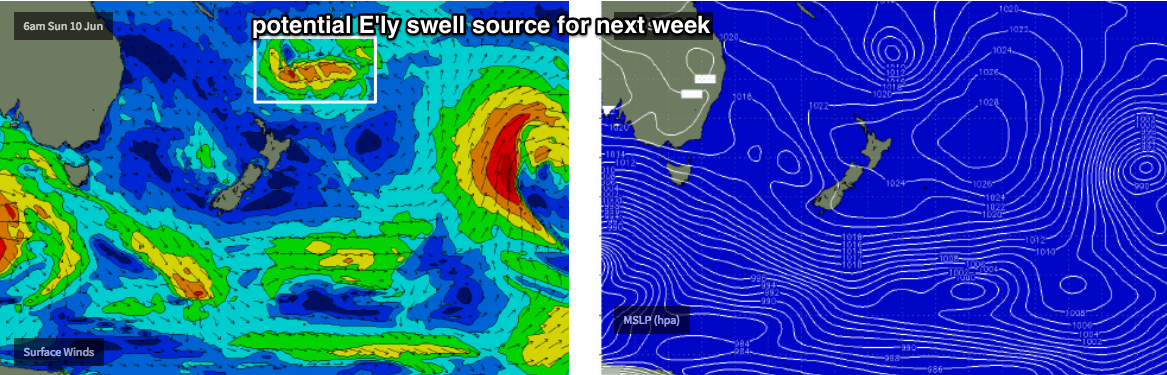
As mentioned on Friday, the end of the model runs have an unseasonable tropical low forming near Fiji this weekend and meandering north of new Zealand in a manner which may generate some small but useful E’ly swell for us next week. Let’s wait and see how things pan out over the coming days.
Otherwise, there is a suggestion that we’ll see the weekend’s trough throughout the Tasman Sea evolve into a low pressure system of some description early next week, though its usefulness from an East Coast perspective remains to be seen.
See you Wednesday!