Mixed bag of mid-range swells and SE winds

South-east Queensland and Northern NSW Surf Forecast by Ben Matson (issued Monday 19th February)
Best Days: Outer SE Qld points should have fun waves all week. Mainly onshore winds will affect most open beaches throughout the period.
Recap: Building 4-6ft E’ly cyclone swell through Saturday increased to 6-8ft Sunday morning, before peaking Sunday afternoon, pushing 10ft+ at some exposed spots. However, there’s been a wide variation in reported size up and down the coast, not just from observers but also buoy readings, with the most size/energy seeming to have a high concentration around the Gold/Tweed Coasts. Wave heights were still pushing 6-8ft at some coasts this morning but we’ve seen a steady easing trend throughout the day. Winds have been out of the south and thus ideal for the regional points.
Today’s Forecaster Notes are brought to you by Rip Curl
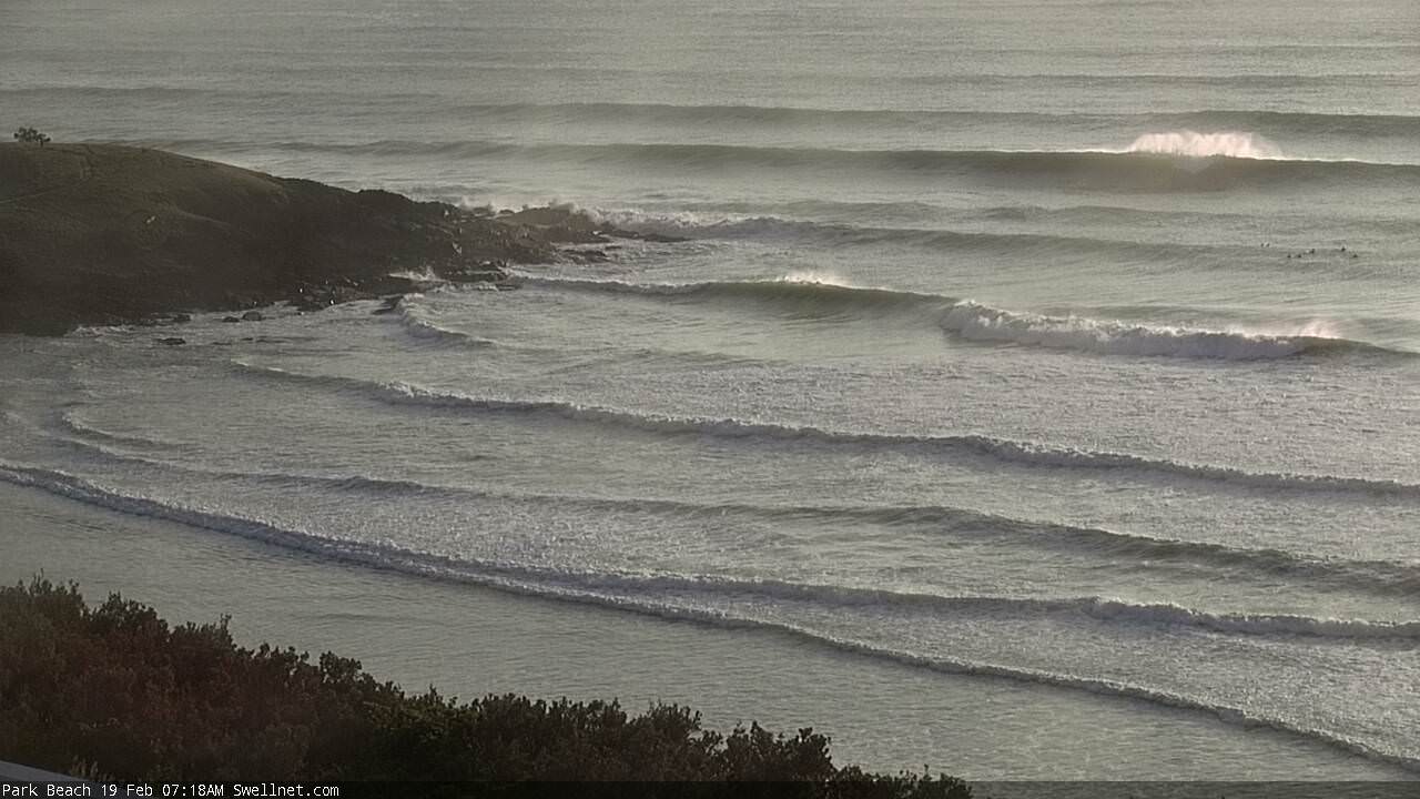
Solid 6-8ft bombs in Coffs Harbour this morning
This week (Feb 20 - 23)
First up - thanks everyone for your reports and comments in these Forecaster Notes over the last week (and indeed the last sixteen years), as we’ve monitored this cyclone swell event. As well as providing plenty of light entertainment, everyone’s input is valuable from a scientific point of view - as the data collection of surf obs is much more sporadic and coarse than I’d prefer - so your real-time commentary helps to improve the service.
As to how this swell performed - I’m limited on time today (Craig is on leave, so I’m doing his forecasts too) and I’d like to do a quick hindcast of the event - I’ll try to do this tomorrow. But in short, I’m reasonably pleased with how it all panned out across SE Qld and Northern NSW - most regions saw strong, sizable swells as expected (not very often that we see long period cyclone swells build from 4-6ft to 6-8ft then 10ft, then back to 6-8ft over the space of four days).
However some aspects of the forecast didn’t eventuate at all, and some regions saw a smaller-than-expected peak in surf size (indeed, Southern NSW dipped out a lot), so I’d like a little more time to delve into why this occurred. Stay tuned for more.
So, moving right along into the current forecast, and now that we’re on the backside of this E’ly swell, we can expect a steady easing trend through Tuesday. A strong high pressure system south of Tasmania is driving a ridge along the East Coast, and this will freshen S’ly tending SE winds over the next few days, which will confine the only rideable options to sheltered points.
We’ll see a low to average quality short range S/SE swell build in the wake of this fetch, but those beaches picking up most of the size (in Northern NSW) will be pretty poor in quality thanks to the accompany winds. A small SE swell should also fill in simultaneously, generated by a brief fetch on the bottom flank of TC Gita, but it’s tracking southwards away from our swell window which majorly reduces its potential.
Northern NSW open beaches may see ordinary 4-5ft+ surf at south facing beaches through Tuesday and Wednesday, whilst north of the border we’re looking at fun surf rebuilding back to 2-3ft on the Gold Coast points, slightly smaller on the Sunshine Coast (bigger surf at south swell magnets and exposed northern ends).
Tuesday morning should see plenty of leftover E’ly swell too, somewhere in the 2-3ft range across the points, though it’ll be easing steadily during the day.
The remnants of ex-TC Gita will reform off the West Coast of New Zealand’s South Island on Tuesday, forming a broad fetch of gales that will give rise to a brief flush of SE groundswell through Thursday. This should provide 4-5ft sets across south facing beaches in Northern NSW, though the angle won’t be great for SE Qld so it’ll be small here, maybe 2ft to occasionally 2-3ft across the Gold Coast’s outer points, bigger at exposed northern ends however smaller on the Sunny Coast. Expect slow, inconsistent sets that'll certainly lack the strength and push seen over the last few days.
A developing coastal trough across the Central Qld coast mid-week will develop a decent E/SE fetch into SE Qld’s near swell window to end the week. The downside is that this will keep conditions below average at most beaches (though the points should be workable) however it’ll also kick up some punchy local surf in the 3ft+ range that should favour most beaches through Thursday and Friday. Wave heights will initially be concentrated around the Sunny Coast but models are in general agreement that the trough will push south into Friday and start to favour the Gold Coast. In any case expect smaller surf from this source south from the border.
Winds across for Northern NSW will veer E’ly on Thursday then NE on Friday; no major strength but you may have to dive into a sheltered northern corner for the best options to finish the week as Thursday’s SE swell eases.
This weekend (Feb 24 - 25)
Looks like a patchy weekend of waves.
The only notable swell source is the Coral Sea trough just north of SE Qld, which will probably weaken, leading to an easing of short range E’ly swells. 3ft sets are possible on the Gold, Sunshine and Tweed Coasts to begin with but it’ll get smaller as the weekend progresses, and surf size will be smaller south from Byron.
Worse, we’re looking at developing NE winds all weekend (strongest on the Mid North Coast), which will limit the number of clean options.
Next week (Feb 26 onwards)
Noting major on the long term charts for now.
Comments
Great diplomacy there Ben. The tone in some of the 'expert contributors' in the last few days were a bit too sharp in my view, but you've done a super job right through with Gita.
Gotta say I'm quite surprised with witnessing some 10' surf here on the GC that it did not come in bigger with Gita's track over the last week. Perhaps if there was a big fat High pressure anchored over NZ, it might have been different.
Witnessing clean Kirra at size is quite special. The guys on jetski's zig-zagging through the line-up should be dragged to shore and have the shit beaten out of them.
Shoulda seen the Tweed bar on Saturday! Cross-shore and windy, but ridiculous. Way way past 10'
Don't beat yourself up, Ben.... All in all it was a pretty good call, mate.. Solid 8 foot, up to 10 at times... Funny how the first call is usually the right call.
The lack of fetch (cradle from a high) was the major factor in the uneven spread.
I note the Moreton buoy is still at 2.7m with 4m plus max.... Still pulsing now.
Hey Sheepy
Been watching the back and forth size prediction from the sidelines. You really know your stuff! I’m impressed hehehe
Where was it 10ft? Don’t be specific, just general area...
Hmmmm... I.... I don't ..... I don't know if this is a set up :/
bahahahaha.... Definite 10 foot bombs off some islands near a bay that shares it's name with a bug.
But hey check that pic of Brent Dorrington, Goofy..... is that 4 foot in vicco measurements? ;)
Damn fine slice of cyclone swell, that one... Was hoping the swell might rip all that extra sand away from big groyne.... Need another big one soon.
Definitely not a set up, genuinely impressed.
I’d call that 3-4ft. You know he’s only 2.5ft tall ha ha ha.
Seriously though it’s been great watching everyone throw their hat in the ring with predictions. Good work
Ben your forecasting has been absolutely brilliant with a high level of accuracy for a very long time. I always recommend Swellnet to everyone as the best source of accurate detailed forecasts. Well backed up by your observers with early, accurate and regular reports. Some of the “comments” from this event were pretty average and if they don’t like what you have forecast and complain they can go to any of the other forecast sites that are in general much less reliable. Don’t back off or change your style. Well done Ben.
Ben I’m pretty happy with a 95% confidence interval which seems to be your strike rate on accuracy. The words uttered here are GOSPEL. But spill the Beans on why another Business has sacked it’s Local reporters and now issues meaningless Junk Generic reports.
Are we witnessing a fallout from the Surf Stitch debacle?
History is a strange animal, but apart from a couple of exceptional rides at Kirra/Superbank on Sunday, I don't think Gita is going to go down in the record books as any kind of benchmark swell event.
It had it's moments for sure but measured against the almost insane levels of hype it generated it fell way short when measured against other hall of fame swells, which it had the theoretical potential to match or surpass.
That's no slight against Ben's forecasting, which contained all the important caveats which became pertinent as the swell unfolded from day dot.
Anyhow, bring on the next one.
Yeh, it just mysteriously never got it's act together; and it was neither classic nor perfection; it was big, very thick and strong. Constant varying set sizes made it interesting in the lineup. I'd give it a 6/10 in hindsight but Gita had the possibility of being a frothing 10/10. I've never seen a category 4/5 cyclone track in a fairly straight line from Tonga towards Byron Bay for nearly a week. Unprecedented is my call too.
Some guys were sitting really really wide off Snapper on Saturday morning, and were even going left on some of the bombs!
I enjoyed admiring the chargers out there; they got some big thick fast barrels, but equally got punished hard and frequently. Strangely enough, I think the Coolangatta stretch was the pick taking into consideration the crowds/sweep further up the line and the jetski retards tearing around Kirra.
Gita...
Predominately 4ft, occasionally 6ft and I saw about an hour of peak swell on Sun arv with a few 8ft waves which everyone wore on the head.
1 broken board and even rode a twin fin one day.
I think everyone could agree ,that the last few days on the gold coast, has been pretty close to Ben's forecasting estimates. Great job mate.
Especially loved reading every one's input as well.
This cyclone for me represents a whole bag of conditions, and some great waves, even sitting out and watching the ski's, and hell men tackling it with great skill.
In the most crowded line up , undoubtedly in the modern world, swell like, that puts it all into perspective.
The debate continues....
Totally agree with most of the above,cyclone swells are usually a lottery anyway so all in all pretty good call by Ben...probably a lot to be learn't here,ie why was the Ballina area not getting the swell when north and south of it bit were.?
Amen Gita.
So did anyone count the seconds between waves of a set, and confirm 20sec surf? 17sec? Etc. That might help narrow down the source. We might find, okay it's not like only the Goldy (and lmnc) got the swell from the core of the cyclone when it was at peak intensity or something.
However it was a tight fetch and cyclone went down when great circle goes up. Don't suppose you can estimate fetch/ core size from eye size and features in satellite images..?
Hey mate. I was on South coast of Fiji main island when core passed approximately 300 km to the south. We had 1 and 1/2 days of moderate to strong winds...nothing stronger than 30 odd knots, which was surprising. I'm guessing the fetch was confined to a pretty narrow band of ocean....it moved erratically along this stretch too, but mostly pushed straight West before running into New Caledonia and breaking up to some extent. Hope this helps.
Hahaha to busy paddling my ass before the next set wave come to be counting how long.
Well after all the hype Gita sorta delivered on the M/nth/coast. Exposed locals saw 8ft + waves where as a certain point break underperformed with very slow set waves(2 or 3 bombs per hour). Pity we didn't have a strong supporting high to really ramp it up! Thanks for your dedication in your reporting of this event Ben!
Hope those exposed locals had sunscreen on the right places ay groovie .
Bloody long wait for the open green faces on that semi unridden point, luckily the exposed locals had plenty of sun protection on those lulls!
Thanks for the nice comments everyone. I've received plenty of addtional feedback overnight (you may or may not be surprised to learn that there's an exponentially larger number of people quietly watching these forums from the sidelines, who don't wish to participate publicly) - almost all of which validates a lot of the reports we received regarding the height of the swell.
I'll try to get the hindcast done some time today.
Jeez, the Gold Coast never fails to surprise me. I'll leave these two concurrent surfcam snapshots from earlier this morning to sum up the situation.


One word..........."Sheep"
Smaller and less consistent across Northern NSW today but this one set delivered the goods at The Pass.

Easy 8 to 10 ft down here on mid north coast last couple of days with dangerous currents and a swimmer swept away at valla.
Starting to settle down abit now
Hey Ben....ever considered stock market analysis.........your forecasting skills in Swellnet could transfer easily to finance markets.....just saying
One thing that stood out as really unusual was the effect the tides had on such a significant swell system. The incoming tides really seemed to ramp up the energy in the water where I felt... "Yew - here comes the swell!"...but then the tide dropped and the swell virtually disappeared in volume and intensity?
when is the next one coming, i feel lost!!
Surfed the Pass on Monday . Didn't count the period - but on a few sets , not all, the gap between waves was huge - like half a soccer field.