Extended period of NE tending E'ly swells from Thursday onwards; sizeable over the weekend

South-east Queensland and Northern NSW Surf Forecast by Ben Matson (issued Monday 22nd January)
Best Days: Plenty of great surf from Thursday onwards as a Coral Sea low sends NE trnding E/NE and E'ly swells across our region. Could become sizeable over the weekend and early next week.
Recap: The weekend delivered great waves, though mainly south the border. SE swells eased slowly across Northern NSW from 3-4ft to 2-3ft on Saturday, and further from 2-3ft Sunday. North of the border, exposed northern ends saw 2ft+ sets Saturday, easing to 1-2ft Sunday. The outer points and remaining beaches were a little smaller. Wave heights levelled out this morning around 2ft south of Byron, and 1-1.5ft across SE Qld. Winds have been out of the southern quadrant, resulting in clean conditions across many locations and also clear, warm waters.
Today’s Forecaster Notes are brought to you by Rip Curl.
This week (Jan 23rd - 26th)
Lots to look forward to over the coming week or two (or three) though the next few days will remain very small with minor residual energy across the coast.
A small long period south swell may glance exposed parts of Northern NSW on Tuesday afternoon (followed by a second, smaller south swell Thursday and a third pulse Friday) but set waves will be very inconsistent and there won’t be much size on offer.
Interestingly, model guidance has 0.4m @ 17 seconds Tuesday lunchtime (Coffs Harbour) which suggests some decent sets around the 2-3ft mark, but the source of this energy is not particularly reliable so I’d be hesitant to expect much more than a stray 2ft wave every fifteen or twenty minutes.
Elsewhere, Tuesday and Wednesday will see small peaky leftovers similar to today. Winds should be generally light out of the E/NE.
While this is happening, a deepening tropical low will be meandering in the Coral Sea, ridging up against a Tasman high and strengthening E’ly winds about its southern flank. This system will initially develop in SE Qld’s somewhat infrequent NE swell window, though this initial activity won’t be as strong as later developments in our east swell window.
Eventually, we’ll see a broad ridge develop through the Northern Tasman Sea by the weekend with a chance that the tropical low may remain active along its northern perimeter, enhancing the back half of the fetch. This is a very important factor for the long term outlook.
But back to this weeks developments: this means that SE Qld will see an increase in NE swell from Thursday ahead of a bigger, broader round of swell from Friday onwards as the swell direction slowly clocks E/NE (Fri/Sat) then E’ly (into Sunday).
Thursday and Friday probably won’t see too much local wind south from the Gold Coast, though it’ll be mainly out of the east so the points will offer the best waves. The Sunshine Coast will be closer to the developing system and models have around 20kts E/SE later Thursday and Friday which may restrict options. However, this close proximity to the swell source will also result in more size.
So, how big will it be?
Well, let’s qualify things first up by stating that the further north you are, the larger the surf will be, and the earlier it will kick in.
Thursday should see 2-3ft surf building to 3-4ft across the Sunny Coast, but it’ll be smaller across the Gold and Tweed Coasts (building to 3ft). On Friday, easterly winds will slowly ratchet up and wave heights should build by another foot or two, which means point-only. So, across the open beaches we can expect 4-5ft+ surf at the Sunshine Coast, and 3-5ft at the Gold/Tweed Coasts by the end of the day.
South from Ballina or Yamba, we really won’t see a notable increase until the weekend. So, expect small surf across the Mid North Coast on Thursday, increasing to 2-3ft Friday with some small trade swell. Between here and Byron, we’ll see larger waves with increasing northerly latitude but ultimately it’ll be smaller than what’s expected in SE Qld. Winds shouldn’t be too much of an issue across Northern NSW (if anything, north from Ballina/Byron on Friday may be a slight problem, but it'll be OK elsewhere) so there’ll be fun beachies around the traps - banks pending, that is.
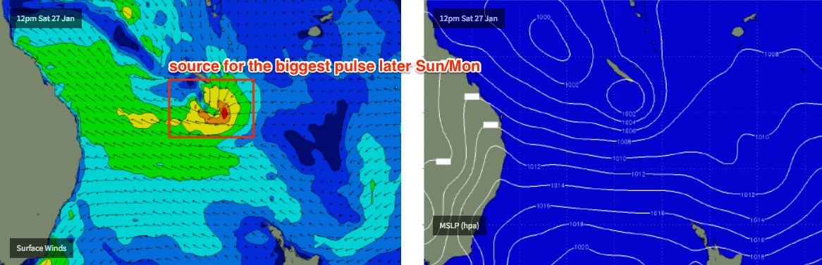
This weekend (Jan 27th - 28th)
The southward-tracking tropical low will anchor a broad ridge through the Northern Tasman Sea from Friday onwards, and a long E’ly fetch will generate excellent E’ly swells that’ll persist for quite some time.
In fact it’s looking like there’ll be too much size for the open beaches for most coasts, which means you’ll have to work around the points and other sheltered spots. Winds will be fresh and gusty from the SE quadrant across all coasts this weekend too.
SE Qld and Far Northern NSW look to be the biggest beneficiary north days with solid 4-5ft+ surf on Saturday building to 5-6ft+ on Sunday. Surf size will be slightly smaller as you head south from Ballina but not by any major degree.
Let’s take a closer look over the coming days to see if there are any significant changes. But, this pattern has been on the cards for a little while now so confidence is certainly quite healthy at this early stage.
Next week (Jan 29th onwards)
Depending on how the embedded tropical low develops over the weekend, we could be looking at a slightly bigger pulse early next week before wave heights level out through the middle part of next week.
Model guidance is estimating some pretty sizeable figures for Monday (in and around the 6-8ft mark at exposed beaches) which corresponds with the deepening low at the back of the fetch, working on a fully developed sea state thanks to the stationary ridge of the previous few days. However the size of this swell and the accompanying gusty S/SE winds will confine the only rideable options to a handful of sheltered points.
In fact, the longer term model guidance suggests there’s a whole lotta tropical activity to bear down through the Coral Sea for the next few weeks, all of which points to two or three weeks of fluctuating trade swell from the east and northeast.
Ain’t it good to have our summer trade swells back on the horizon! We’ve missed ya, big fella.
Comments
Nice Ben. Very nice.
Looking good for locals ie waves out of a holiday period well deserved, bring it on.......
Not wrong! Well overdue for some mid week peak conditions.
Thanks Ben, always appreciated, especially when it's good news : )
Burleigh pro on this weekend. Expect militant local hanger-on flogs trying their best to keep the plebs (aka recreational surfers) at bay. Can a jet ski approach and harass someone in a ‘con’est area’? On which side of the fence does the law sit?
Ben, do you think the Forster region will see anything or will be small like Sydney? Thanks!
Yeah this looks like the real deal.
Sheepdog you're right. 3.5- 4m by Tuesday 30th. Every graph I see a solid 12ft. Massive!
Interesting that the BOM doesn't make reference to any real wind in its forecast. From what I can see on the WAMs if this comes off it's going to blow a gale
Bloody ripper
I’m starting a ‘crowd’ forecasting website....just gonna copy and paste your notes Ben :)
I’m forecasting a packed car park Friday morning.
Still ALOT of divergence in the models on this one people. Sit back and watch them evolve.
And if you ask me.....EC looks to be the much better solution IMO.....long lined groomed E'ly groundswell. GFS could well be a mixed bag and possible bank buster.
EDIT: Surprise Surprise, the latest 00z run of GFS appears to be aligning more with EC now!!
Well the ants are on the move upwards in my house and they are usually spot on ..little cunts...but anyway looks like a lot of rain coming .........if their right .
Gold Coast Waters have climbed to 27*near Boiling Point by Monday/Tuesday (inshore > 30*)
Bali wax-stick sales will go thru-the roof.
Corresponding East/Southerly Winds climb to over 30 kts by Tuesday/Wednesday
Whipping up Swell to 2.5m - 3.5m +
Fast-track 'Windytv' to Tuesday and it clearly shows 'Acme' Cyclone raging on our doorstep.
By Thursday it fizzes out. (It is what it is!)
A Week brings much change for Cyclones/notorious for backing down this far south.
Battered fish circling Paperboys/Whole ocean is brewing up a red tide...
Either way Noosa crew will be restringing the 400m track lanes.
The small long period south swell was getting into a couple of spots on the Tweed this morning, a fair bit of a wait for the sets but occasionally we'd see the odd 2ft+ bomb. Super clean too, no wind at all.
Been a fun January so far.
Fingers crossed.
Summer is a strange time for me. I both love and hate the whole time. It's crap having people overrun everything but the energy of everyone on holidays is great.
Pretty cool seeing kids covered in ice cream and learning to snorkel in the shallows. Mums and dads chilling out as the cicadas blare.
Then someone goes and turfs a dirty nappy and the rubbish from their picnic lunch on the high tide line at the most popular stretch of beach in town and you start to rethink the whole exercise.
Both models now have the tropical low stalling up around New Cal. EC looking more favourable than GFS in terms of swell from the SE flank of the low as GFS places this fetch behind New Cal. Will mean NE groundswell is delayed now (if it occurs at all).
Any north swell coming tomorrow donweather
There's a teeny tiny NE swell currently showing on the models for today and tomorrow....but it's small, peaking tonight around the SC. 0.5m @ 10 sec (43 deg). I don't ever have a lot of faith in the models with these such acute angled NE swells given the GBR which extends way out into the Coral Sea. But if the above swell was to be in the water it should essentially be there now so take a look at the Noosa cam to see if there's some little inconsistent 1-2ft runners coming through.
Been getting a few Little Earth tremors last 36 hours.
Had a pearler 5 minutes ago.
Did the Earth move for you too ?
I take you're around here Blowin?
https://www.coffscoastadvocate.com.au/news/bigger-earthquake-possible-af...
Near enough Don.
Might be the lemon next to the pie. Could be a larger one coming down the track.