Smaller weekend ahead; good surf prospects from late Wednesday onwards

South-east Queensland and Northern NSW Surf Forecast by Ben Matson (issued Friday 19th January)
Best Days: Fun beaches Sat/Sun mornings whilst winds are light. Late Wed/Thurs onwards for a new E/NE tending E'ly swell.
Recap: The expected renewal of S/SE groundswell overnight Wednesday delivered another round of large waves across northern NSW into Thursday, in fact we didn’t really see much of an easing trend during the day at all. South of Byron, exposed south facing beaches were still consistently 8ft with 6ft+ sets on the Tweed, and 3-4ft waves across the outer Gold Coast points. Size eased back slowly overnight, with solid 6ft sets still gracing south facing beaches south of Byron this morning, however it’s been much smaller across SE Qld coasts (though slightly bigger than expected), around 2ft+ on the points and larger surf at exposed northern ends. Winds have been early W/SW tending moderate S’ly then S/SE throughout the days.
Today’s Forecaster Notes are brought to you by Rip Curl
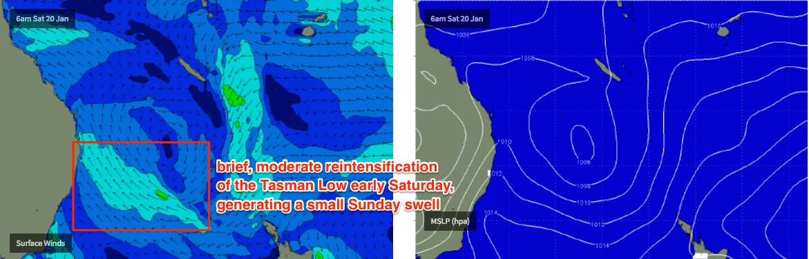
This weekend (Jan 20th - 21st)
Synoptic activity is slowly easing and wave heights are abating across the coast. But fortunately, the Tasman Low responsible for five days of large south swell is still present in our swell window, and will actually redevelop a moderate SE fetch off Northern NSW into Saturday that’ll maintain fun peaky waves across exposed Northern NSW beaches into Sunday.
Surf size will be biggest south of the border this weekend, specifically south from Byron where we should see 3-4ft sets at south facing beaches early Saturday down to 2-3ft during the day. The reinforcing SE energy won’t deliver any more surf but should result in most open beaches holding between 2ft and maybe 3ft into Sunday. Expect smaller surf at beaches with less southerly exposure.
Winds across Northern NSW will be generally light and variable with afternoon sea breezes, becoming fresh at times north from Yamba after lunch. So aim for a morning session for the best waves.
Across SE Qld, surf size will be smaller and there won’t be much action across the outer points - just some small slow peelers in the 1ft, maybe 1-2ft range. Exposed northern ends will be your best bet with peaky 2ft+ surf Saturday, easing slightly into Sunday.
Winds will freshen from the SE during the day, so aim for the mornings when it’ll be light SW.
Next week (Jan 22nd onwards)
The first half of next week will see small residual swells across the coast, and mainly light morning winds and afternoon sea breezes (becoming moderate to fresh NE across the Mid North Coast).
However, we have a few systems on the long range charts that are offering better size potential from late Wednesday or Thursday onwards.
A broad tropical low developing east of Fiji this weekend is still expected to move slowly south, then south-west into our swell window. But at the moment, it reaches maturity just NE of New Zealand later Tuesday or Wednesday, with just enough strength to generate some small inconsistent lines for our coast next weekend, perhaps in the 3ft range. Let’s take a closer look on Monday.
Also, the models have been to-ing and fro-ing with regards to a possible Coral Sea trough or cyclone over the last few days, and it’s still certainly on the cards. At this stage we’re looking at this stage starting to gather steam E/NE of the SE Qld region later Tuesday, which should bring about a building E/NE tending E’ly swell across SE Qld and Far Northern NSW from late Wednesday through Thursday (with a slight delay across the Mid North Coast).
Early size indicators are in the 3-5ft range at exposed beaches though confidence is low at this point in time.
Model guidance then has this system slipping further south and focusing towards Southern NSW and the Mid North Coast, however this is a long way in model land and we’re likely to see plenty of adjustments over the coming days.
Either way, it’s certainly a dynamic period ahead so let’s see how things are playing out in Monday’s updates.
See you Monday!