Tricky forecast period; dicey winds and a Sunday night peak

South-east Queensland and Northern NSW Surf Forecast by Ben Matson (issued Wednesday 4th October)
Best Days: Thurs: early small peaky waves at exposed beachies. Sun: clean early with a mix of S'ly swells (small in SE Qld). Solid pulse through the a'noon but dicey winds expected at this time. Mon: solid S/SE swell (small in SE Qld) but problematic winds for the points, beachies will be your best bet.
Recap: Tuesday delivered great waves across most locations, with winds swinging light and variable through the morning, and the E/NE swell building to 4-5ft across SE Qld and Far Northern NSW. The afternoon delivered some really nice waves across the points as surface conditions cleaned up. Today we’ve seen excellent conditions just about everywhere though the E/NE swell has eased steadily in size. Fortunately winds have remained light in many locations. Surf size has been smaller across the Northern NSW coast south from Ballina both days.

Noosa this morning

The Pass this afternoon
This week (Oct 5 - Oct 6)
Surf size will continue to ease from the E/NE through Thursday. It’ll be clean in the morning at most locations with early light offshore winds, but moderate NE breeze are expected from lunchtime across SE Qld and Far Northern NSW, and they’ll become fresh across the Mid North Coast.
We should see very occasional 2ft to maybe 2-3ft sets at reliable swell magnets in SE Qld and Far Northern NSW around dawn, easing 1-2ft throughout morning and into the afternoon. Expect smaller surf south from Ballina.
Friday looks very uninteresting with no new swell and a strengthening N’ly breeze (may be N/NW at times). A gusty S’ly change will push into the Mid North Coast mid-late afternoon but it won’t be enough to save the day for what’s expected to be small weak leftover swells. Aim for a protected northern corner early morning if you’re desperate.
This weekend (Oct 7 - Oct 8)
We’ve got a complex weekend of surf conditions ahead.
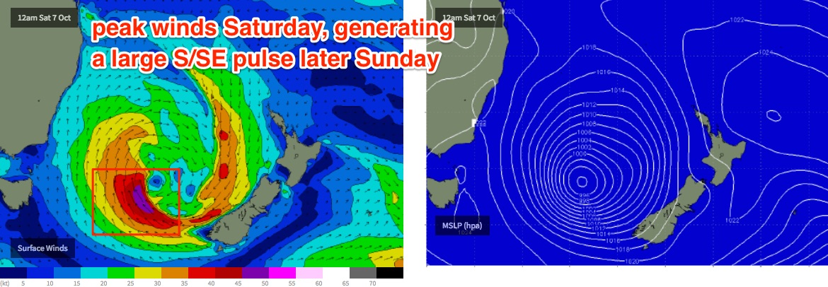
A developing Tasman Low on Friday is expected to display some very strong winds but most of it will be aimed into Southern NSW, so picking the size in Northern NSW (and SE Qld) is problematic.
Fortunately, we can seperate this weekend into two seperate swell events, originating from different parts of the low. As such Sunday is the pick of the period because local conditions will also be at their best.
Saturday will deliver building short range S’ly energy in the wake of Friday’s late change (on the Mid North Coast). Most of this fetch will develop inside the swell shadow of the Hunter curve, and in any case will be mainly low quality windswell. Moderate to fresh S’ly quadrant winds will bump up exposed beaches picking up the swell (occ 3-4ft+ sets by the a'noon), and it’ll be tiny at protected locations offering cleaner conditions.
Across SE Qld, we won’t see much, if any size across the outer points (1-2ft by the afternoon, smaller earlier) and exposed northern ends will be bumpy (1-2ft building to 2-3ft).
As such, Saturday looks like a lay-day across most coasts.
Sunday looks much better, though the timing of this new groundswell is still not perfect for our region. The Tasman Low is expected to wind up S/SE gales on its southern flank overnight Friday and into early Saturday, producing a strong S/SE tending SE swell for Sunday with size expected to reach 4-6ft range at south facing beaches south of Byron by the end of the day.
However, this pulse is not due into the Mid North Coast until the early-mid afternoon and the Far North Coast (and SE Qld) until mid-late afternoon.
The problem with the timing of the swell is that we’re looking at early light offshore winds through the morning, but moderate to fresh NE sea breezes after lunch. So despite the likely high quality of this groundswell, local conditions may spoil the potential across Northern NSW as it builds into the afternoon.
For what it’s worth, we should eventually see 2-3ft surf across the outer SE Qld points and 3-4ft+ surf at exposed northern ends once the swell finally pushes north of the border - though this will probably occur under the cover of darkness on Sunday night.
In fact, current model output is suggesting a brief period on Saturday where surface winds may push 45-50kts (see below) and if this plays out as suggested, we may see an embedded period of larger surf pushing 6ft+ at reliable swell magnets (south of Byron) - though this is modelled to arrive after dinnertime (perhaps mid-late afternoon on the Mid North Coast if we're lucky).
Prior to the arrival of this energy, we will see a smaller mix of S’ly and S/SE swells for the Sunday morning session, around 4ft at south facing beaches south of the border and 2ft at exposed northern ends in SE Qld (a little smaller on the Sunny Coast). This is your best window of opportunity to surf this weekend.
Next week (Oct 9 onwards)
Sunday’s solid SE swell will peak overnight and ease through Monday. Early morning should see some 5-6ft sets at south facing beaches south of Byron (smaller elsewhere), with 2ft+ sets across the outer Gold Coast points and 3-4ft sets at exposed northern ends.
However, winds will remain out of the northern quadrant, favouring the beachbreaks early under a NW flow. Expect size to ease rapidly throughout the day, maybe by half.
A gusty S’ly change is expected early Tuesday and it’ll renew moderate S’ly swells across Northern NSW through the afternoon and into Wednesday, plus some small short range SE swell for the SE Qld region as a ridge builds through southern Qld waters. However, nothing worthwhile is expected and these swells will be short lived.
In fact we’ll be back to northerlies by Wednesday afternoon and Thursday ahead of another S’ly change (and possible south swell for Northern NSW) due later next week. More on this in Friday’s update.
Comments
snapper before everyone woke up
See ya east swell, you've been very well behaved.
Yes it was a nice surprise.
Ben, can the Alex headland cam go back to swiveling/rotating now?
Cheers
Yep, I'll get on to that shortly.