Drought breaker on the way for Queensland surfers

South-east Queensland and Northern NSW Surf Forecast by Ben Matson (issued Friday 29th September)
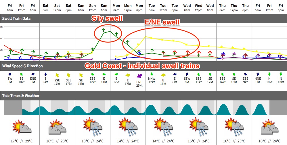
Best Days: Sun: solid S'ly swell building across Northern NSW (small in SE Qld, arriving after lunch) but local winds may spoil conditions at many coasts. Mon: building E/NE swells in SE Qld/ Far Nthn NSW; winds look dicey though. Tues: punchy E/NE swells with light winds developing in SE Qld and Far Northern NSW. Wed: easing E/NE swells with S'ly winds developing.
Recap: Strengthening N’ly winds generated punchy local swells on Thursday, but conditions remained onshore and poor north of about Ballina. South across the Mid North Coast, winds became light and variable as a trough cross the region, leading to cleaner conditions and fun beach breaks. Today we’ve seen a small mix of easing NE swell and minor S’ly swell, up to 2ft at exposed beaches in northern NSW, and smaller across SE Qld. Some south swell magnets have seen occasional bigger bombs near 2-3ft out of the south (such as Coffs Harbour, as per the image below) but this has largely been the exception rather than the rule. Conditions have been clean under a light variable wind though. Afternoon sea breezes have ranged in direction from the S/SE across Northern NSW, to the N/NE across the Sunny Coast.

Southerly swell at Coffs Harbour this afternoon
This weekend (Sep 30 - Oct 1)
It’s a bit of a mixed bag this weekend.
Saturday’s looking a little ordinary thanks to the lack of any new swell, and a tricky wind outlook as a weak change pushes up the coast. This will freshen winds from the south across most locations though early morning should see light variable winds in most locations.
Without any new swell, we’ll be relying on small leftover S’ly energy south of Byron (maybe some stray 2ft sets at south swell magnets, tiny elsewhere, and easing during the day). North of the border there won’t be much on offer at all.
A ridge behind the change will maintain moderate to fresh SE winds across SE Qld and Far Northern NSW into Sunday morning - with only an outside chance of a period of light winds early morning. These winds may ease late in the day and veer E’ly but for the most part conditions will be a few notches below desirable.
Similar winds are expected south from Yamba though a little lighter in strength, with variable conditions likely in the afternoon as the ridge weakens.
However, the good news is that we’ve had a decent upgrade for the south swell expected on Sunday - back inline with what I was projecting last Monday - and this may override the average surface outlook at some locations, mainly Northern NSW.
The reason for the upgrade is mainly related to a strengthening of the front exiting eastern Bass Strait on Saturday morning. Strong southerly energy should fill into the Southern NSW coast later Saturday, reaching the Mid North Coast early Sunday morning and the Far North Coast by mid-late morning (so, expect small residual surf prior to its arrival).
This swell will peak through the afternoon, reaching 4-6ft at exposed south facing beaches, but as per the notes above surface conditions are looking tricky as it’s hard to have confidence in how much the cross-onshore tending onshore breeze will throttle back by.
But, there should be sufficient pushing the swell to allow for small waves at protected spots, and these will probably be your best option.
North of the border, we won’t see much size across most Gold and Sunshine Coast beaches and points (1-2ft+) but exposed northern ends should see larger surf through the afternoon, reaching 3ft+ by the end of the day. Conditions won’t be great though. Expect slightly smaller surf on the Sunny Coast too.
Next week (Oct 2 onwards)
As mentioned in the comments in Wednesday’s forecast notes (on Thursday), early next week suddenly got a heck of a lot more interesting. And the good news is that the models haven’t shied too far away from what’s shaping up to be a positive swell (and rain) event for SE Qld and Far Northern NSW.
Essentially, a high pressure system in the Tasman Sea will freshen the trade flow south of New Caledonia, but a developing trough across the eastern states will focus its attention along the coastal strip into one or two small low pressure systems, where wind speeds will be concentrated.
This is expected to generate some solid short range E/NE swell, though many locations are going to cop the onshores - mainly on Monday.
To be honest, this is quite a fluid situation and will need to be reviewed over the weekend (which I will do in the comments below) but for now, Monday's model guidance looks like a write-off at most coasts under strengthening E’ly tending NE winds, along with building E/NE swell to 4-5ft+ across open beaches in SE Qld and Far Northern NSW, extending south to the Mid North Coast during Tuesday (in fact bigger surf is possible, if winds muscle up a little more than is projected).
However, these kinds of unstable patterns often see periods of light winds that go against the broadscale model outlook, and the upwards phase of these local swells can often be quite strong - so I can't discount the chances for some good waves at a handful of locations that offer at least a partial degree of shelter. This has certainly happened across analogous synoptic setups before, so don't discount the possibility of waves just yet.
Monday morning should also see plenty of south swell early on (in Northern NSW) though it’ll be rapidly easing.
Tuesday is where windows are likely to start opening up for surfers, mainly throughout SE Qld as the trough moves south and (slightly) east, allowing winds to become light and variable, along with plenty of strong E/NE swells of a similar size to late Monday. However the onshores may persist south of Ballina through Tuesday. Southerlies are then expected from Wednesday onwards as the system gradually weakens, with slowly easing E/NE swells.
While this is all going on, a series of broad secondary fronts trailing the system responsible for Sunday’s southerly pulse will maintain small to moderate levels of south swell across Northern NSW through the first half of next week. No major size is expected, but in general we should see a base level of inconsistent 2-3ft surf at south facing beaches with a couple of embedded pulses pushing into the 3-4ft range, currently slated for late Tues and then again late Wed and early Thurs.
The only other source of swell for next week is a small but intense polar low that’s modelled to meander off the Antarctic ice shelf immediately south of of New Zealand from Monday onwards. It’s likely that a fair percentage of the fetch will be over ice - so therefore not in a position to produce swell - but we’ll be able to confirm this via ASCAT observations next week. In any case, small, long period S/SE energy is possible around Friday at south facing beaches, maybe some intermittent 2ft sets if this system is very well behaved. Certainly not worth working around though.
See you Monday!
Comments
Bring it on! My lawn could really use a drink too.
Feels like it hasn't rained in half a year. Be nice to see some sand moved around too.
Great forecast Ben, the level of detail and nuance is appreciated!
"across analogous synoptic setups...don't discount"
I love an alliterative surf report.
Ha! It was unusually unintentional too.
Ok, that last one was though :)
Not much around this morning though a few small waves at south facing beaches south of the border.
Better than expected winds across a few locations this morning, though for most coasts there's hardly any surf to take advantage of.
However, the new south swell seems to be into the Coffs region this morning - so should be into the the Far North Coast by lunchtime.
Southern NSW buoy data suggests a quick peak though, so make the most of what you see today as there won't be much around tomorrow.
Well maybe it was in the water but i cant find it ...worse than yesterday .
Which coast mate?
Ben wasn't much happening at all this morning but your forecast was spot on,swell jumped and is 4-6 ft way too south and too straight for around here ,coffs area,blowing light ene now but really no where to go unless you like close outs.Anyway you nailed it well done .
Thanks mate!
Wind up here on the Sunny Coast was looking good until 5am when it swung due east. Made for a bumpy early grovel.
Nice clean leftovers in Coffs this morning (first two images are the same wave!).
Its actually raining.