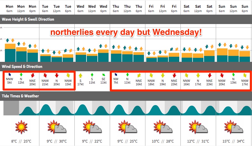
Terrible run of spring surf ahead; Thursday the only option

South-east Queensland and Northern NSW Surf Forecast by Ben Matson (issued Monday 18th September)
Best Days: Thurs: fun mix of south swells in Northern NSW, and early light winds. Only small in SE Qld.
Recap: Southerly swell eased slowly through Saturday, before bottoming out into Sunday morning. We’ve seen a new S’ly swell kick in late Sunday and holding strongly through today with 4-5ft sets south of the border and occasional 2-3ft waves at SE Qld south swell magnets.

D'Bah still picking up some fun sets this afternoon
This week (Sep 19 - Sep 22)
Tuesday looks very ordinary with easing S’ly swells and strengthening N’ly winds that could reach 20kts+. If you’re quick, protected northern corners south from Byron may have some peaky options but it’s not worth too much attention. Elsewhere will be smaller and blown out.
A minor N’ly windswell may show up at north facing breaks throughout the day but I am doubtful there’ll be anything worthwhile. Fresh S’ly winds will fill in behind a shallow change early Wednesday morning though there won’t be enough oomph behind the change to generate a notable swell increase.
The S’ly change will be linked in with a strong front pushing across Tasmania throughout Tuesday, and this will be the source for a decent increase in south swell across the Mid North Coast on Wednesday afternoon, and the Far North Coast early Thursday. Wednesday afternoon’s winds will be fresh S’ly though so conditions won’t be worthwhile in Northern NSW (and it’ll be tiny in SE Qld).
A second pulse of swell from the core of the low will fill in across all coasts on Thursday. Wave heights should initially reach 3ft at south facing beaches (south of Byron) from the first swell later Wednesday, and then up to 3-4ft throughout Thursday (early peak in the south, later peak in the north) - though surf size will be much smaller at beaches will less southerly exposure. North of the border I’m not expecting much size at all across the points, with just a few 2ft+ sets at exposed northern ends in SE Qld throughout Thursday.
However, we should see early light offshore winds and afternoon sea breezes on Thursday, which designates this day as the best option throughout the entirte forecast period.
Easing S’ly swells are expected on Friday with winds restrengthening from the north, becoming gusty into the afternoon.
The only point of interest to finish the working week is a small secondary low south of the main low (responsible for the late Wed/Thurs swell) that is expected to slingshot through the lower Tasman Sea on Wednesday. This should provide a flush of fresh south swell for Friday afternoon - probably just the Mid North Coast, possibly the Far North Coast close to dark if we’re lucky.
The models aren’t picking up this swell very well - I’ll need a few more days to confirm the specifics - but south swell magnets south of the border may pick up some 2-3ft+ sets in the few hours before COB. They’ll be the only surfable options anyway under the northerly breeze.
This weekend (Sep 23 - Sep 24)
The weekend looks terrible.
Fresh and gusty N’ly winds are expected across all coasts, both days. Friday’s small pulse of south swell will ease through Saturday but the only rideable options will be south swell magnets south of Byron.
These N’ly winds should whip up some local windswells through Saturday, peaking Sunday with possibly some decent sized sets across exposed parts of the Gold and Tweed Coasts (3ft or so) but quality will be hard to find. Let’s hope there’s a chance for a glimmer of a nor’wester in there to allow for a few rideable options. More on this in Wednesday’s update.
Next week (Sep 25 onwards)
Current model guidance doesn’t really favour much swell into the start of next week.
A vigorous frontal system approaching the eastern states over the weekend looks too zonal in alignment and too north in latitude to benefit us in any meaningful way. There is potential for the middle to latter part of next week as the broadscale system moves further east, better positioned within our swell window, but for now the long term outlook is rather small.
In addition to this, we’re likely to see a few more days of northerly winds early next week, compounding the poor swell outlook. They'll continue to generate local windswell but that's a moot point.
So, make the most of what you see this week! It could be a little while between drinks into the longer term.
Comments
Far out Ben. Talk it up. Lol
Just tac this spell onto the last 3 months for the sunny coast. Whats another 2 weeks in the grand scheme. The things i'd do to need a bottom turn...
It's 2 weeks until Boxing Day?
Not much across most coasts under this northerly, but still a few waves inside protected northern corners south of the border. Exhibit A, Coffs Harbour.
WarHawk Im glad you said that. I've gone nuts these last few months! Its been the longest flatspell STH swell dominated season I can remember. Almost made me think about moving back to the Gold Coast. Actually thats a lie.... nothing would get me back there!
Hot , hot westerly blowing.
I feel absolutely no sympathy
The wind is so hot and dry that I found a red bellied black snake lying just out of reach of the Shorey at the bottom of the tide.
I actually think it came out of the ocean as there was no tracks leading down to it and the beach is currently about 100 m wide at dead low where I found it.
Big effort if that's the case. The nearest headland was about 7 kms away and the surf is 3-4 ft on the outside bank.
Big snake.
Hope you got it to safety Blowin. Love Red-bellied blacks and they are in trouble.
Red-bellied blacks mostly eat cold blooded animals: amphibians and other snakes. They keep brown snake populations under control but their numbers are being decimated by cane toads.
Brown snakes mostly eat warm blooded animals: rats and mice and so aren't bothered by cane toads.
fucking cane toads
I love snakes so I thought I'd give it a helping hand. Tried lifting its guts with my fishing rod as you would with a snake hook but it was way too heavy.
Like I said , it was a big snake.
Old red wasn't too keen on this idea and had a bit of a tantrum so I gave him some space.
He wasn't going anywhere in a hurry though so I'd say he was rooted from the big lap up the coast.
Tell you what is amazing and that's all the lace monitors I've been seeing around the coast lately. Vibrant colours and very confident . A few nice bearded dragons . A cool green tree snake a couple of days ago.
Fuck all bait around off the beach. Got a good flattie on a soft plastic though. I'm keen to catch more of them . So tastey.
A lot of cane toads here at the moment . But it is school holidays up there ....