Several funky swells ahead - N'ly Thurs, S'ly Fri onwards

South-east Queensland and Northern NSW Surf Forecast by Ben Matson (issued Monday 14th August)
Best Days: Tues: small clean waves early at south swell magnets south of Byron. Wed: small N'ly windswell at N facing beaches in Northern NSW. Thurs: fun peaky N'ly windswell across the Gold and Tweed Coasts. Fri: building S'ly swell across Northern NSW, solid into the a'noon. Sat/Sun: large S'ly swell building across Northern NSW, only small in SE Qld but clean on the outer points (best Sun as winds veer S'ly and the swell peaks).
Recap: Easing S/SE swell across Northern NSW on Saturday gave way to a tiny day of waves on Sunday, ahead of an afternoon pulse of S’ly swell across the Mid North Coast. This produced 3-4ft surf at south facing beaches for much of today, however conditions have remained tiny in SE Qld.
This week (August 15th - 18th)
Today’s south swell will ease into Tuesday and we’re looking at early light offshore winds ahead of a freshening N’ly flow into the afternoon. If you’re south of Byron, you may pick up a few 2ft sets at south facing beaches early morning but I doubt there’ll be much away from these locations. SE Qld will remain tiny.
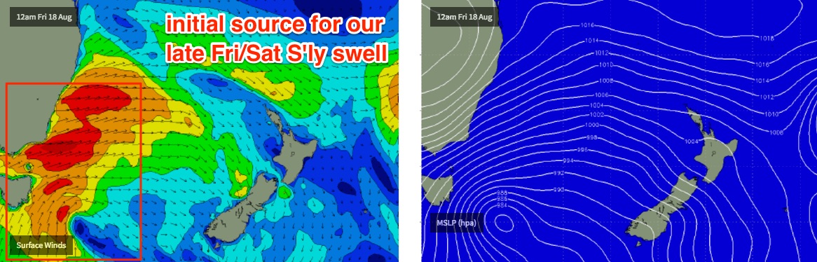
We’ve got a very dynamic weather pattern ahead, mainly centred around a series of vigorous fronts pushing across the SE corner of the state. For the most part, this means we have a chance for a couple of funky south swells from Thursday afternoon onwards, and in particular we’re looking at a heavy south swell for exposed locations over the weekend.
But, prior to this there’s another interesting region of swell generation that may keep us active at some unusual locations.
Tuesday afternoon’s freshening northerly trend will become strong to gale force through Wednesday morning. The wind will back to the NNW at the same time, which isn’t great for swell prospects in Northern NSW though the sheer width of the fetch should lend itself to a small N’ly windswell south from Byron Bay on Wednesday - perhaps some 2ft, maybe 2-3ft sets at a handful of exposed locations, and improving into the afternoon as the wind NW eases from the south (i.e. Mid North Coast seeing this easing trend first, reaching far Northern NSW overnight). Keep your expectations low as it'll probably be pretty small and weak.
This broad N/NW fetch will clear into the Tasman Sea overnight Wednesday, largely outside of the region’s swell window.
However, what is of more interest to me is that the tail end of the fetch will linger across SE Qld waters at strength overnight Wednesday, and the fetch will be better aligned for exposed north facing beaches across the Gold and Tweed Coasts (and to a lesser degree, the Sunshine Coast, owing to a shorter fetch length).
Our model is suggesting wind affected 4ft surf at north facing beaches on the Gold Coast very late Wednesday, easing from a little smaller size (2-3ft) early Thursday, with winds veering W/NW throughout the day as the swell continues to ease into the afternoon.
As such, I’d pencil in Thursday morning for an early surf across an exposed north facing beach between Byron and the Gold Coast, with sets around 2-3ft, producing unusual lefts running down the coast. Expect smaller surf across the Sunshine Coast.
Size will however be much smaller south from about Byron/Ballina due to the swell direction.
As for our south swell window, Wednesday and most of Thursday look pretty uninteresting. A brief region of strong W'ly winds exiting eastern Bass Strait on Wednesday currently look like they may not have enough south in their direction to generate surf for Northern NSW, but this may change over the coming days so I'll reassess on Wednesday. At this stage I'm leaning away from there being any meaningful surf however we may see some late 2ft sets across the Mid North Coast on Thursday, holding into Friday but only available at a handful of reliable south swell magnets.
Otherwise, Northern NSW is expected to deliver another funky south swell on Friday from the same acute swell window the generated yesterday’s and today’s waves. Except, this time ‘round it’ll probably be bigger thanks to a broader, stronger and more sustained fetch.
This system is quite impressive, in fact we’re looking at some very large W/SW swells pushing across the central/northern Tasman Sea to New Zealand’s North Island, plus Tonga, Fiji and Samoa.
A much smaller percentage of energy will spread back into the Northern NSW coast. Again, we have to be careful with size estimations as small tweaks in the fetch’s modelled orientation between now and Thursday could dramatically influence wave heights.
But for now, we should see south facing beaches south of Byron starting small but building into Friday afternoon. It’s also worth pointing out that unlike directional south swells - which track somewhat linearly up the coast - this event is expected to ‘spread’ back into the mainland (originating from W/SW gales off Southern NSW), and thus may arrive much more simultaneously across the region.
As for size - early indications are for late sets pushing 3-5ft at some south swell magnets south of Byron, but much smaller elsewhere. Sometimes we see these unusual swell events spread right back into the Gold Coast (but to a lesser degree the Sunshine Coast) so for now I’ll estimate 2-3ft sets at exposed northern end of the Gold Coast right on dark, but not much elsewhere. In fact we may see this swell arrive a little too late to be of use to us north of the border. But it's well worth keeping an eye on.
In any case, Friday will be nice and clean across the beachies with fresh W/SW winds.
As a side note, you may have observed a deepening trough SE of Fiji mid-week (this has been discussed last week in these notes). However it’s not well aligned for our region and moves too quickly south through the swell window. So, I’m, not very excited about its swell potential right now. There is a pretty robust fetch of trade winds further east but they’re a very long way from the mainland so the resulting trade swell will probably lose most of its size by the time it reaches the Australian mainland. I will however keep a watch on this.
This weekend (August 19th - 20th)
Stronger secondary fronts rounding the Tasmanian corner on Friday - still a part of the same broader system exiting into the Tasman Sea from late Thursday - will generate a better aligned S/SW fetch that will contribute bigger swells into Saturday and Sunday.
The main risk we have on Saturday is that these fronts will also track up the coast, bringing a S’ly change to the coastal strip after lunch. However in doing so they’ll also kick up wave heights.
Right now expectations are for early W/SW winds and 4-5ft surf at south facing beaches south of Byron (much smaller elsewhere), and very small across SE Qld away from south swell magnets that could be in the 2-3ft range.
Gusty S’ly winds will then probably develop into the afternoon (early afternoon Mid North Coast, mid-late afternoon Far North Coast and SE Qld) and surf size should building by another foot or two (with a smaller increase in SE Qld).
This southerly airstream will linger into Sunday morning though begin to veer back to the SW at many locations, and ease in strength. Wave heights will initially be quite solid out of the south but will also ease in size throughout the day, though with this wind only protected points will offer clean conditions and they’ll be comparatively small compared to exposed south facing beaches (5-6ft+ south of Byron).
SE Qld looks like delivering some small clean runners across the outer points on Sunday, perhaps 2ft+ though exposed northern ends could be almost twice that size. Expect slightly smaller surf across the Sunshine Coast than the Gold Coast.
Next week (August 21st onwards)
We have more mid-latitude lows for next week and more south swell! But we’ve got more interesting things to focus on in the short term so let’s take a closer look on Wednesday.
Comments
Wow. Ben what hope is there for us sunny coasters this north swell? Take off a foot from GC report?
Bought a set of al byrne quads for such an occasion, the great mythical wave. Has it been dredged ____,
Lots of questions I know, but would the swell period be 8 seconds or less on the sunny coast do you think? And gold coast would be 8-10? I'd happily drive to the GC its a weekday who pencils a day off on n wind swell?
I don't think the periods will be that high, it's a local windswell. Regardless, the Goldy has more size potential than the Sunny Coast.
Had a ball today.
Water still warm. A frame wedge takeoffs into bowly lefts.
Crowded at 10 people out including a very famous surfer....mellow guy, pleasure to surf with.
How's the forecast maximums for the next few days:
26 degrees on the Gold Coast today (29 tomorrow); 30 at Ballina and Coffs Harbour today, 31 at Evans Head.
This is mid-August!
Small level of windswell on the Tweed already.
2ft at D'Bah now. No-one out except a lone kiteboarder.
Found a section of beach today that had waist to chest high lefts spinning along the edge of an extremely shallow sandbank like a section of Chicama this morning.
Crystal clear and fun with the strong winds blowing cross -offshore .
Gutless as fuck though.
Still , always nice to get wet with no one around.
Noice.
How's the temps.. Coffs Harbour maxed out at 33.2 degrees today, Port Mac reached 32.4 degrees and Evans Head reached 32.1 degrees.
...and August (WTF) Northerlies to go with it around here. Not even nice swimming weather.