Small E'ly swell for Northern NSW on Saturday; more S'ly swell next week

South-east Queensland and Northern NSW Surf Forecast by Ben Matson (issued Friday 4th August)
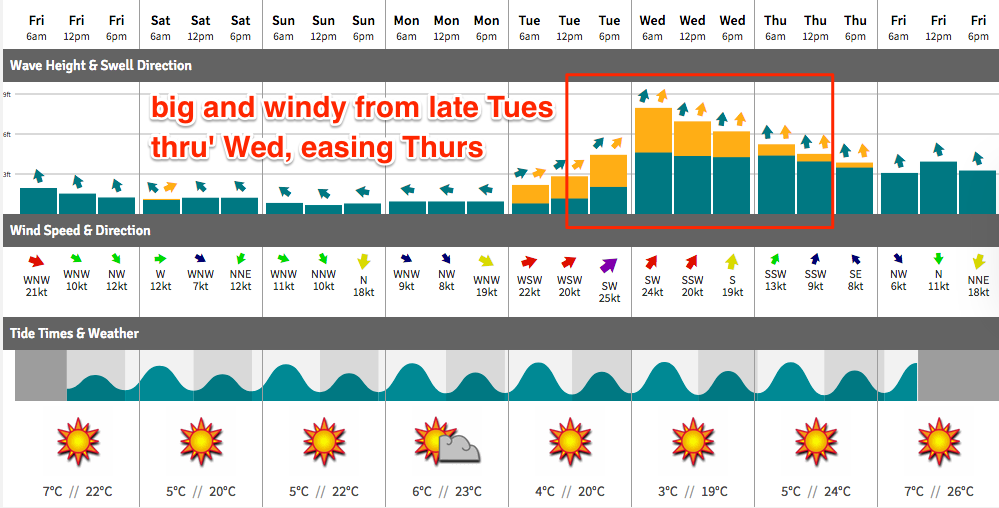
Best Days: Sat: small E'ly swell in Northern NSW, mainly south from Coffs. Unlikely to be much in Far Northern NSW or SE Qld. Tues: chance for a late pulse of unusual S'ly swell in Far Northern NSW and the Gold Coast. Wed: large, windy S'ly swell in Northern NSW, though very small in SE Qld away from south swell magnets. Thurs/Fri/Sat: low confidence for a SE groundswell.
Recap: Easing S/SE swell produced very nice waves early Thursday with 4-5ft sets at south facing beaches south of Byron, and smaller waves elsewhere. SE Qld really dried up quickly though exposed northern ends were still around the 2-3ft mark. Surf size abate into the afternoon and today has seen very small surf across most coasts. A minor NE windswell was evident across the Gold Coast this morning, otherwise it’s been a non-event as we wait for a small new E’ly swell to fill in across the Mid North Coast.
This weekend (August 5th - 6th)
Surface conditions are looking excellent for the beaches Saturday and early Sunday. But, there won’t be a lot of surf around.
You will have to make the most of Saturday if you're planning to get wet at all. A small new E’ly swell is expected to arrive later today, generated by a small but decent mid-week E/SE fetch exiting western Cook Strait (the body of water between NZ’s North snd South Islands). Although it’s not here yet, satellite passes on Thursday morning showed a healthy 30kts+ extending into the Tasman Sea.
Unfortunately, this fetch was mainly aimed towards Southern NSW so across our region we’ll see the most size across the Mid North Coast (inconsistent 2ft+ sets) with smaller surf as you head north. I doubt we’ll see much, if anything of interest in SE Qld. Conditions will be clean with moderate W/NW winds. Weak sea breezes are possible into the afternoon.
On Sunday, this swell will fade right back and with no new swell expected, we’re looking at very small, weak surf across the entire region with freshening NW winds. They’ll tend gusty N’ly into the afternoon across the Mid North Coast, a little lighter to the north.
Next week (August 7th onwards)
A significant cold outbreak will push across the SE corner of the country this weekend, however this system is riding quite north in latitude so the pre-frontal flow will be NW through most of our southern swell window.
As such Monday will begin with tiny surf. Exposed north facing beaches may pick up some small N’ly windswell originating from Sunday’s late freshening trend (which will probably become quite gusty overnight) but I’m doubtful for much more than a weak 1-2ft at reliable swell magnets on the Gold and Tweed Coasts. Winds will veer offshore (W/NW) which will clean up the open beaches but also iron flat this small windswell (if it eventuates).
The large mid-latitude low crossing the mainland over the weekend will reform in the Tasman Sea overnight Monday, forming W/SW thru SW gales off the Hunter and Mid North Coasts into Tuesday.
Some locations north of here - I’m thinking Yamba to Byron, and to a lesser degree the Tweed and Gold Coasts - should see a brief pulse of unusual directional south swell fill in through Tuesday afternoon - in actual fact, a spread of SW swell (hence why it’ll be smaller south from the Upper Mid North Coast, due to the axis of the fetch). It’s hard to pin down a size, but such predictions are a moot point at this stage given that thos beaches pick up the most size (late afternoon 4-5ft sets) will be quite wind affected with strong to gale force sou'westers. Expect smaller waves at protected spots. I'll have a better idea on this in Monday's notes.
A brief flush of large local S’ly swell is then expected Wednesday, from the core of the Tasman Low itself. The models have moved around a lot in the last few runs so I’m expecting to revise these numbers again on Monday - but for now we could be seeing wind affected 5-6ft+ surf at south facing beaches in Northern NSW, and smaller waves elsewhere. Winds are likely to remain fresh SW.
Across SE Qld, the swell direction will likely restrict size across the points (2ft+ Gold Coast, smaller Sunny Coast) but exposed northern ends could be twice this size, though very wind affected.
This swell will then ease rapidly from Thursday with much lighter winds. Thursday is probably the pick of the forecast period at this stage.
Looking further ahead, and had I written these SE Qld/Northern NSW notes a few hours ago, I would have gone on at great length about a possible SE groundswell for next Thurs/Fri/Sat, generated by an unusual E’ly fetch wrapping around the southern tip of new Zealand South Island mid-next week, extending north into the Tasman Sea. This was highlighted in the Southern NSW notes which were published much earlier.
Unfortunately, the latest 00Z model run (made available just a short time ago) has completely changed the structure of the system generating this swell so I’ve lost all confidence in there being a strong swell event. We’re still on target for some kind of decent SE swell throughout this time frame but I’m loathe to go into great detail (again!) as it’ll likely chop and change over the weekend.
So, let’s just pencil it in and I’ll revise in more detail on Monday.
Have a great weekend!
Comments
Tiny lines at Currumbin earlier this morning, rolling unbroken over the bank and eventually spilling on the shoreline (how's the boat wake through the usual lineup position!).
And now on the lower tide, it's only just breaking.
Still a few baby waves rolling through at Caba for the national longboard titles.
Looks like the NE windswell has kicked up a bit since early morning.