Tasman Low to provide fun mid-week waves in Northern NSW

South-east Queensland and Northern NSW Surf Forecast by Ben Matson (issued Monday 31st July)
Best Days: Tues onwards: building S/E tending SE swells across Northern NSW, biggest and best Wed PM and Thurs AM. Into Friday, we may see a small combo of swells across Northern NSW with offshore winds. Don't expect much in SE Qld this week, only Wed/Thurs have any chance for a wave, and even then mainly at exposed south swell magnets.
Recap: Saturday saw plenty of fun south swell across Northern NSW, with sets around 3ft+ and light offshore winds keeping conditions generally clean. This swell eased slowly throughout Sunday though the early morning still managed 2ft sets at south facing beaches. Wave heights were tiny across SE Qld all weekend. Today we’ve seen tiny to flat conditions and freshening northerlies (continuing on from Sunday afternoon’s breezey conditions).
This week (August 1st - 4th)
First up: there’s no sign on the buoys of the small expected long range E’ly groundswell, generated over a week ago well to the south-east of Tahiti (!). It was never expected to deliver anything amazing in the surf department anyway, however its lack of appearance is not of any great concern - weak swells that travel such vast distances are often hard to pin down the precise timing of. We’ll probably see a faint signal on the buoys into Tuesday once all of this local windswell noise clears away.
Extremely inconsistent 2ft sets are still possible at reliable swell magnets through Tuesday and Wednesday but I wouldn’t make any plans around it.
Looking towards more closer swell sources, and a new low is developing off the Southern NSW Coast at the moment. This will be our primary source of swell for the next few days across Northern NSW. However, SE Qld will largely dip out in the size department due to the position and alignment of this low.
Initially, a thin fetch of S’ly gales developing along the low’s western flank will strengthen and then rotate outside of our swell window. This will generate a brief flush of S/SE swell throughout Tuesday but compounding things in the surf zone will be a fresh SW tending S/SW airstream. As such, those beaches picking up any notable size will be quite wind affected. Expect bumpy 4ft+ sets across the Mid North Coast by the afternoon (smaller at beaches will less southerly exposure), starting from a small base in the morning. The Far North Coast may not see a decent kick in size until very late.
Wednesday and Thursday have much better potential from this system.
We’ll see some short range S’ly swell fill into south swell magnets (south of Byron), originating from the accompanying S/SW fetch developing between the low and the mainland. However, a better secondary S/SE fetch is expected to develop across the southern flank of the low later Tuesday, and it's expected to briefly push north - working on the active sea state generated by the low's earlier incarnation (possibly exhibiting a minor captured fetch scenario) and this will provide a more useful mid-range swell through Wednesday and Thursday. South facing beaches south of Byron should reach 4-5ft+, but again, it’ll be much smaller elsewhere owing to the strong southerly component in the swell direction.
More importantly, local winds will quickly relax on Wednesday as the low moves eastwards, away from the coast, so we’re looking at light variable winds (possibly a lingering SW flow early morning, but improving during the day). The afternoon is probably your best choice on Wednesday as the swell should be more established by this time.
Thursday morning will see light variable winds and a similar size at first across Northern NSW, ahead of an easing trend throughout the day, so aim for an early paddle. A developing coastal trough will bring strengthening northerly winds into the afternoon, and they’ll wipe out conditions away from all but the most protected northern corners.
As for SE Qld - Wednesday and Thursday should see fun waves across SE Qld’s handful of south swell magnets and exposed northern ends, with occasional 2-3ft+ sets (a little smaller on the Sunny Coast near 2ft+). But away from these exposed locations it’ll be very small and inconsistent, due the swell direction.
Early Thursday morning is probably the pick of the period, though the initial push of the swell front could result in a couple of hours of more consistent activity up front on Wednesday. I'll update these thoughts over the coming days once the low is confirmed by satellite data.
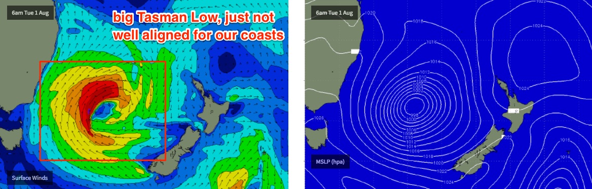
Friday looks interesting for Northern NSW. We’ll see a smaller combo of easing S/SE swell (from Thursday) and a minor mid period E’ly swell, originating from a secondary fetch exiting western Cook Strait over the coming days, in conjunction with the Tasman Low (see below). Set waves could be around the 2-3ft range at first but will probably ease to 2ft throughout the day.
Also, the Gold and Tweed Coasts may see an early peak in local N’ly windswell, originating from Thursday’s late gusty winds. It’s still a line call as to whether it’ll be worthwhile; current estimations are in the 2ft range at exposed north facing beaches, but it's expected to peak overnight and will abate very quickly - probably by mid-morning. I’ll have more confidence on this in Wednesday’s forecast.
This weekend (August 5th - 6th)
Saturday looks pretty small at most beaches at this stage.
The mid-period swell due Friday should persist into Saturday morning with very infrequent 2ft sets tailing off throughout the day, biggest across the Mid North Coast with slightly smaller waves across the Far North Coast and very little in SE Qld.
Offshore winds will become strong to gale force in Southern NSW but shouldn’t be too much of a problem north from Seal Rocks. So conditions will be nice and clean.
These gales are expected to be quite W’ly in direction through Bass Strait, even W/NW if anything - so our favourite flukey source of south swell is a low confidence game at this point in time, for Sunday that is.
I certainly wouldn’t rule it out for now, as it’ll only take five or ten degrees to suddenly make a big change in the outlook - but right now chances are that most of Northern NSW and SE Qld will be pretty small on Sunday.
Next week (August 7th onwards)
A large, slow moving deep low pressure system in the Southern Ocean linked to the weekend’s fronts will finally push into our swell window around Monday, which should give rise to a couple of days of strong southerly groundswell through the early to middle part of next week - however once again, only Northern NSW looks like it’ll benefit with SE Qld expected to remain tiny for the foreseeable future. More on that in Wednesday’s update.
Comments
Thanks for the forecast Ben. Are you expecting the wed sunny coast arrival in the evening?
'As for SE Qld - Wednesday and Thursday should see fun waves across SE Qld’s handful of south swell magnets and exposed northern ends, with occasional 2-3ft+ sets (a little smaller on the Sunny Coast near 2ft+). '
Cheers
That small East swell was hitting here today.
Which Coast are you on Blowin, and what sort of size was it, measured in Gary's?
Nth Mid North coast.
Roughly the height of Gary's sculptured pectorals on the sets. But wedging nicely on a shallow bank where I was.
That's decent, given how large his pectorals are.
If the bank wasn't as defined as Gary's abdominals it probably wouldn't have been rideable.
Quick heads up (mainly Northern NSW) - the initial S/SE swell has come in bigger and earlier today across Southern NSW than expected. As such expect a similar trend across Northern NSW today (bigger, earlier).
The Crowdy Head buoy (Port Macquarie) is now showing a recent strong increase but it hasn't pushed across Coffs Harbour yet. Can't rule out some late lines across SE Qld either. I'll take a closer look at the specifics over the coming hours.
You just using the MHL site Ben for the wave buoys ..or is there another secret squirrel site for the live read ?
Ports Authority of NSW have a really good buoy off Botany Bay. We've found its more useful and reliable than MHL's Sydney buoy.
http://wavewindtide.portauthoritynsw.com.au/
Otherwise, MHL have the only other publicly available buoy data in NSW. There are a few local buoys/gauges/sensors here and there but they're either not public, or not real time.
Have you had a chance to cast your eye over this again yet Ben?
Man these SE QLD forecasts are farked up for the weekend warriors, like me... urrrrrgh!! LOL! My beer drinking practice is the only thing getting a workout these last few weeks! Haha!! Fk!
second undercall in a row on this system.
Couple of lines at select spots on the sunny coast coming through now. Tomorrow morning should be nice