Active weekend of swell and wind, complex possibilities for next week

South-east Queensland and Northern NSW Surf Forecast by Ben Matson (issued Wednesday 7th June)
Best Days: Fri: small/mod building E/SE swell across Northern NSW, though with tricky winds. Not much size in Far Northern NSW or SE Qld. Sat/Sun: large E/SE swell in Northern NSW, but wind affected. Smaller in SE Qld, with a chance for better winds here. Next week: plenty of swell from the east and south, though low confidence at this stage.
Recap: Surf size has remained relatively small across all coasts for the last few days.
This week (Jun 8 - 9)
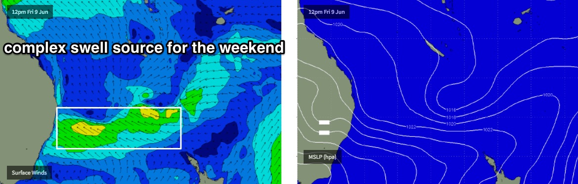
A developing Tasman Low off the southern NSW coast hasn’t favoured swell production for our region today, and we haven’t see very much size across Southern NSW either.
This system will freshen southerly winds across coastal regions on Thursday and Friday though it won’t generate much, if any new swell thanks to a relatively low wind speed and only thin fetch width.
The Tasman Low will meander off the Mid North Coast for the next few days and into the weekend, and in doing so will broaden an E’ly fetch around its southern flank. This will generate a new SE swell that will build across the Mid North Coast on Friday, though initially a little later and smaller than was expected in Monday’s notes (conversely, the weekend will be bigger.. read on below).
Additionally, surf size will decrease with increasing northerly latitude - so we’ll see only small waves in the Far North and tiny surf in SE Qld on Friday.
As for size, expect locations south of Coffs to see an increase into the 3ft+ range throughout Friday - likey undersized early morning - with smaller surf to Yamba (2-3ft) and then 2ft surf north to the border by the afternoon.
As for SE Qld - I’m not expecting much action here over the next few days, however there ss a small tropical disturbance in the Fiji/Vanuatu region, and a small associated easterly fetch on its southern flank was expected to nose just south of New Caledonia today, into our swell window - before forming a small surface low on Thursday. There’s no major strength or length in the fetch, but I can’t rule out a couple of stray 2ft sets from this source at exposed beaches showing later Friday (though to be honest, it may be hard to discern from the small building SE swell too).
Anyway, it’s a small, low confidence event so keep your expectations pegged appropriately.
This weekend (Jun 10 - 11)
We’ve had yet another major model swing in the last few days.
Friday’s southerly change has been weakened considerably, and instead of a new Tasman Low forming and driving southerly gales across the Tasman Sea, we’re now likely to see the incumbent system - by this time meandering just off the Mid North Coast - hugging the mainland, and slowly broadening a surface trough to the north.
This pre-existing Tasman Low will in fact strengthen as it approaches the Mid North Coast, bringing strong onshore winds and large surf to the region. The models have 6ft+ surf for the entire Northern NSW coast on Saturday, which seems a little high but certainly can’t be ruled out. Winds would be gusty SE though so there won’t be many options out of the wind.
In any case this scenario will certainly favour the SE Qld points with smaller waves (say, 3ft+ outer points, smaller at protected spots, with the swell direction being more SE), though I’m hesitant on the Sunshine Coast's potential as the fetch will be mainly aimed towards the Mid North Coast so we’ll be seeing a spread of swell to the north, rather than a direct source. And this scenario doesn’t often favour protected locations north of Brisbane very well.
Anyway, a broad trough is expected to develop along the coast north of the Tasman Low over the weekend, but it’s hard to work out where the axis will be and therefore where winds may have a chance at swinging SW. At this stage you’d be safest in SE Qld but obviously surf size will be a lot smaller here than across Northern NSW.
So I've got only low confidence on the specifics right now, as we’ve already had a lot of chops and changes in the last few days - I'm expecting this to move around before the weekend once again.
So, short story is: plenty of E/SE swell for the weekend, but tricky winds.
Next week (Jun 12 onwards)
If the latest model guidance is to be believed - and there’s loose agreement across the board right now - the coastal trough/low across Northern NSW this weekend will slide south to a position off the Central NSW coast, before intensifying an East Coast low off the Sydney region around Monday or Tuesday.
For our region, there are a couple of swell sources of note: residual E/SE swell from the weekend, building E/NE tending E’ly swell from the associated tropical infeed, and then possibly a return S or SE swell through the middle to latter part of the week, from the East Coast Low (if and when it forms).
But in reality there’s a vast number of possibilities with this system so we’re really going to have to watch the models day by day to get a grip on the overall trend.
But right now, it’s dynamic with no shortage of size on the long term charts.
See you Friday!
Comments
Ben any chance of southerly winds rather than e/sou /east on the Lower /MNCoast over the long w/end?
Hard to tell to be honest. I'd certainly hedge my bets with a greater chance of onshore winds.
Doing a tour o duty with the family to a nice highrise holiday in Forster be great to see some waves in that area I'd rather camp but with the forecasted weather coming I'll take the comfort
Wow.. latest models have changed subtely at the broadscale, but at the mesoscale it's a massive upgrade for Northern NSW and SE Qld.
How so? Which dates?
Mid-late next week.
Ben is that East Coast low likely to bring anything up to the sunny coast later in the week?
Oh yeah, mid-late next week looks good at this stage. But only low/mid confidence at the moment because of the massive model swings in recent days.
That looks cyclonic !!!!
Models have thrown another curveball for the short term (and long term!) outlook though it's still looking best for SE Qld, compared to anywhere else on the East Coast.
Early clean peaks at Park Beach, winds still offshore on the Coffs Coast.
Tweed Coast picking up some 2-3ft sets now.
Wow next week looks like it will be pumping everywhere...WA, Indo, maldives & east coast yew
ENE swell directions is good for Scotts Head paddle competition the following weekend , whats the swell interval likely Ben ?
Whoa! Bit far away for next weekend at this stage. Will have a better idea early next week.