Windy conditions ahead; hold out until Saturday

South-east Queensland and Northern NSW Surf Forecast by Ben Matson (issued Monday 29th May)
Best Days: Thurs/Fri: strong S'ly tending S/SE swell in Northern NSW but windy at times, only favouring sheltered southern ends. Nothing worthwhile in SE Qld. Sat: strong but steadily easing S/SE swell with rapidly improving conditions. Smaller but fun waves in SE Qld. Sun: small(er) clean waves.
Recap: Excellent beach breaks were reported across almost every coast over the weekend, easing from 3ft Saturday to 2-3ft Sunday and further to 1-2ft today (slightly smaller surf across the Mid North Coast). Winds were light offshore in the mornings, with regions of moderate northerly winds through the afternoons over thew weekend. Winds have been light and variable all day today.
Note: our computer model surf forecast graphs will be a little funky for the next day or two.. read more here: https://www.swellnet.com/forums/website-troubleshooting/352217
This week (Tues 30th - Fri 2nd)
A small south swell is trying to make its presence felt in Southern NSW this afternoon, however the front responsible for the energy had its configuration changed slightly (for the worse) over the weekend. As such I wouldn’t expect much more than a lazy, inconsistent 2ft at south facing beaches south of Byron on Tuesday.
Our current east swell has almost completely dried up, but as per today I can't rule out extremely infrequent 1-2ft across swell magnets on Tuesday, mainly SE Qld and Far Northern NSW. In general expect tiny to flat conditions.
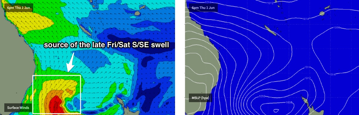
A cold front pushing up the Southern NSW coast overnight Tuesday will then kick off a fresh short range south swell for Wednesday afternoon (Mid North Coast) which will steadily build into Thursday (remaining Northern NSW and SE Qld coasts) as an anchored southerly fetch adjacent the East Coast becomes supercharged thanks to a series of secondary fronts wrapping around a developing Tasman Low.
This will result in an extended period of fresh S/SW thru’ S’ly winds from Wednesday thru' Saturday. There’s a chance for isolated, brief pockets of SW winds in the early mornings, but these will be the exceptions rather than the rule, and likely limited to a handful of usual suspects such as the southern Gold Coast.
Thursday’s initial swell kick will be mainly short range S’ly windswell, and the relatively low period and acute direction won’t favour SE Qld very well. In fact we may not see any useful swell from this synoptic pattern until very late Friday or (more likely) Saturday. Most Gold and Sunshine Coast beaches will probably see minor waves in the 1-2ft range on Thursday and Friday, with bigger surf at exposed northern ends and a handful of outer points (inconsistent 2ft, maybe 2-3ft if we're lucky). But in general I am not expecting much in the way of quality surf north of the border for the rest of the working week.
As the surf builds across Northern NSW from late Wednesday through Thursday and Friday, most exposed beaches will be horribly blown out and protected southern corners will be considerably smaller due to the period and direction. Exposed south facing beaches (south of Byron) should see wind affected 4-6ft sets at the height of the swell but the region's only surfable locations will be much, much smaller.
A bigger, better and stronger S/SE pulse is expected to arrive later Friday, originating from the core of the developing Tasman Low. It’s more likely to influence the Mid North Coast before dark Friday but may not reach Far Northern NSW until overnight. This should push a little higher at times (wind affected 6-8ft sets south facing beaches) but with better options at protected southern ends due to the longer period and larger swell size.
But in general, I don't expect there'll be a lot to work with this week. Windy, directional south swells are always a challenge to find worthwhile surf conditions in Northern NSW and the next few days will be no exception.
This weekend (Sat 3rd - Sun 4th)
Friday’s late kick in large S/SE swell will peak overnight before easing steadily through Saturday, which is currently the highlight of the forecast period.
Very early Saturday morning should see 6-8ft sets across south facing beaches in Northern NSW before it eases to 4-5ft during the day and further to 3-4ft on Sunday. Beaches with less southerly exposure will be considerably smaller.
SE Qld should do OK from this pulse, with 2-3ft+ sets across the outer points early Saturday, slightly smaller surf across most beaches but bigger waves at exposed northern ends around 3-4ft+. Expect an easing trend throughout the day and further into Sunday.
As for local winds, Saturday looks like it’ll still be under the influence of fresh S’ly breezes though with an easing pressure gradient that is a greater likelihood of a broader coverage of early light to moderate SW winds.
Sunday looks nice and clean everywhere with light offshore winds.
Next week (Mon 5th onwards)
An intense low passing south of Tasmania later this week will set up a small long period south swell for Northern NSW later Monday, but no great size is expected at this stage. It’s worth keeping a watch on for potential upgrades over the coming days though, including a possible related low forming off New Zealand’s South Island’s West Coast later in the weekend.
Otherwise there’s nothing of major interest in the long term storm track at this point in time. We have an amplifying node of the Long Wave Trough over the Indian and Southern Oceans for next week (west of SA/WA) so it’ll be some time before the feature moves into our region.
Comments
Still some little lines of leftover E'ly swell on the Goldy today.
Can i ask a (probably) very simple question. Why do northerlies eff up the water so much more than southerlies seem to? Is this exaggerated more so than it is real, or is there something more detailed here?
In what way? Turbidity? Surface chop? Which parts of the coast?
Im on sunny coast. Id say mostly surface chop, but it seems to throw these weird wave angles into the mix too. Maybe its just a case of it not looking normal (southerly swells and winds obviously dominate). Often around here a northerly wind meets southerly swell and it just clashes and gets junky. We dont often get a nth swell with a sth wind so i cant compare if that would look the same or not. But generally nth winds here just turn anything to trash, even relatively light ones.
Probably because they usually coincide with small swells. And if your beach has any hint of facing north rather than south (ie the whole Gold Coast) then northerlies will be more cross/on. Newy/Ballina and a number other places hate a southerly.
Maybe im a bit crazy but if i am at an open beach, east facing with an east swell, i would swear a nth wind would trash it more than a sth. I think a lot of it is simply nth winds (and the tiny wind swell) meeting the primarily southerly flow of things. Im on the sunny coast, so we have a bit of everything in terms of angles
Still some small lines of E'ly swell on the Goldy.
This lil' east swell keeps on keeping on.
A little smaller again, but still stacks of small easterly lines from the deep dark South Pacific.
Still trying at Caba!