Finally! Stacks of swell for Queensland surfers

South-east Queensland and Northern Surf Forecast by Ben Matson (issued Wednesday 22nd February)
Best Days: Good surf in Qld most days, though a little wind affected across the open beaches at times. Biggest surf later Fri/Sat (though VERY inconsistent), then again Tues/Wed with a fresh short range E'ly swell. In Northern NSW, keep an eye out for a fun small S'ly swell Thurs.
Recap: A small E’ly swell is slowly building across the coast, and is now showing 2-3ft sets across SE Qld and Northern NSW. A small S’ly swell is also starting to push into the Mid North Coast (Southern NSW is seeing occ 3ft sets, though will be slightly smaller north of Seal Rocks). Winds are fresh S/SE across SE Qld, tending more SE across Northern NSW and lighter E’ly across the Mid North Coast.
This week (Feb 23rd - 24th)
We’ve got a peak in two primary swells expected on Thursday: the current E’ly swell, and a small distant S’ly groundswell. Plus a small spread of mid-range SE swell from a thin, elongated ridge through the Central Tasman Sea.
Both primary swells should provide 2-3ft sets across the region, in fact with surf size out of the east currently at the top end of model output we may see a few bigger sets across exposed SE Qld beaches around the 3ft+ mark at times on Thursday. Surf size will then ease steadily from these sources during Friday.
Winds look to be similar to what we’ve seen over the last few days; light to moderate S’ly tending S/SE across Southern Queensland (possibly a brief SW breeze early morning), with lighter winds across Northern NSW - early light offshores and afternoon sea breezes.
On Friday, a new long period E'ly swell (relative to most east swells on the East Coast) is due to build in size, sourced from a remote fetch located well to the east of New Zealand earlier this week.
These kinds of swells are quite flukey and with a great likelihood of very inconsistent set waves - owing to the distant swell source - you’ll have to keep this in mind when choosing your destination as for the most part you’ll be surfing smaller leftovers from Thursday's south and east swells, around 2ft.
Surf size will build all day, reaching 4ft across exposed SE Qld beaches by the afternoon. However due to the swell source being located inside the swell shadow of New Zealand, we’ll see smaller surf south of a point somewhere in Northern NSW - probably Byron to Yamba (or thereabouts). It’s hard to have confidence in just how this swell will pan out across the broader coast, but if you were to hedge your bets - there’s a greater chance of size north of the border, and a decreasing size as you travel south of the border.
At least Friday’s winds will be favourable for most of the beaches (light variable with sea breezes), except the Sunshine Coast which could see a lingering SE breeze for much of the day.
This weekend (Feb 25th - 26th)
Friday’s new, very inconsistent E’ly swell will hold into Saturday but slowly ease in size throughout the weekend. Early 3-4ft sets across SE Qld (smaller as you head south from Byron) on Saturday morning will become smaller through the afternoon and further into Sunday.
As mentioned on Monday, the model does have a building swell period through Saturday - owing to a secondary swell source at the back of the distant South Pacific fetch, exhibiting stronger surface wind speeds. But the extra travel distance will probably cancel out the benefits of the longer wavelengths, so there’s no reason to expect Saturday’s surf to be much bigger than Friday afternoon. And it'll be bloody inconsistent too.
As such, I still think wave heights will be downwards all weekend.
Local winds are looking reasonably good; a moderate ridge will develop across the coast throughout Saturday though no major strength is expected. Both mornings should see early SW winds (perhaps not Sunday morning on the Sunshine Coast, due to the presence of the ridge), and we’ll see moderate SE winds develop during the days in all areas.
On the balance, a pretty standard summer weekend of waves. Except for this year, of course.
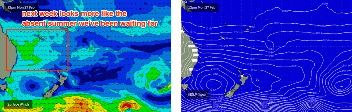
Next week (Feb 27th onwards)
Looks like a whole week or more of fun trade swell ahead for the entire region.
A strong high pressure system in the Southern Tasman Sea next week will drive a broad trade flow through northern waters, producing plenty of E’ly swell for most of the East Coast. It’ll be biggest across SE Qld - peaking with maybe some 3-5ft sets at open beaches around Tuesday, smaller south Byron - but winds will be up from the E/SE so sheltered points will be your best friend.
At this stage the east swell will probably ease slowly mid-week through into the weekend but there’s no sign of a major ceasing of swell activity, meaning we’ve got plenty of waves for some time yet. More on this in Friday’s update.
Comments
"...VERY inconsistent"
"...very inconsistent"
"...very inconsistent"
"...bloody inconsistent"
Expectation management 101 :)
cheers Ben...great to finally see some trade swell on the menu
Yar, cynical as f*ck hahaha
Time to GTFO
https://www.swellnet.com/reports/indonesia/bali/uluwatu/forecast
What's that you say ?
https://www.swellnet.com/reports/australia/south-australia/streaky-bay/f...
Huey very happy with you lately my friend. Get stuck in.