Small southerly swells for the coming days; Friday AM the pick with a NE swell

South-east Queensland and Northern NSW Surf Forecast by Ben Matson (issued Monday 26th September)
Best Days: Tues/Wed: small pulsey S'ly swells in Northern NSW with good winds. Thurs: punchy developing NE windswell, initially poor with N/NE gales but there's an outside chance for a late window of W/NW winds. Fri: fun peaky NE swell for most open beaches, biggest at dawn, with fresh offshore winds. Much smaller throughout the day.
Recap: Friday afternoon’s strong south swell persisted across Northern NSW into Saturday morning though eased steadily in size during the day, ahead of very small conditions into Sunday as the swell bottomed out. Unfortunately, the direction wasn’t favourable for SE Qld so no notable surf was reported here all weekend. A new S’ly swell is building across Northern NSW today though it’s a little slow to get going, which is surprising as we’ve seen solid 3-4ft sets across Southern NSW today. Surfcam vision form Coffs Harbour suggests south swell magnets across the Mid North Coast are seeing occasional 3ft sets (see below), but winds are light to moderate onshore conditions are a little bumpy. Wave heights remain tiny throughout SE Qld, even Far Northern NSW is yet to pick up any appreciable size from this new south swell yet.
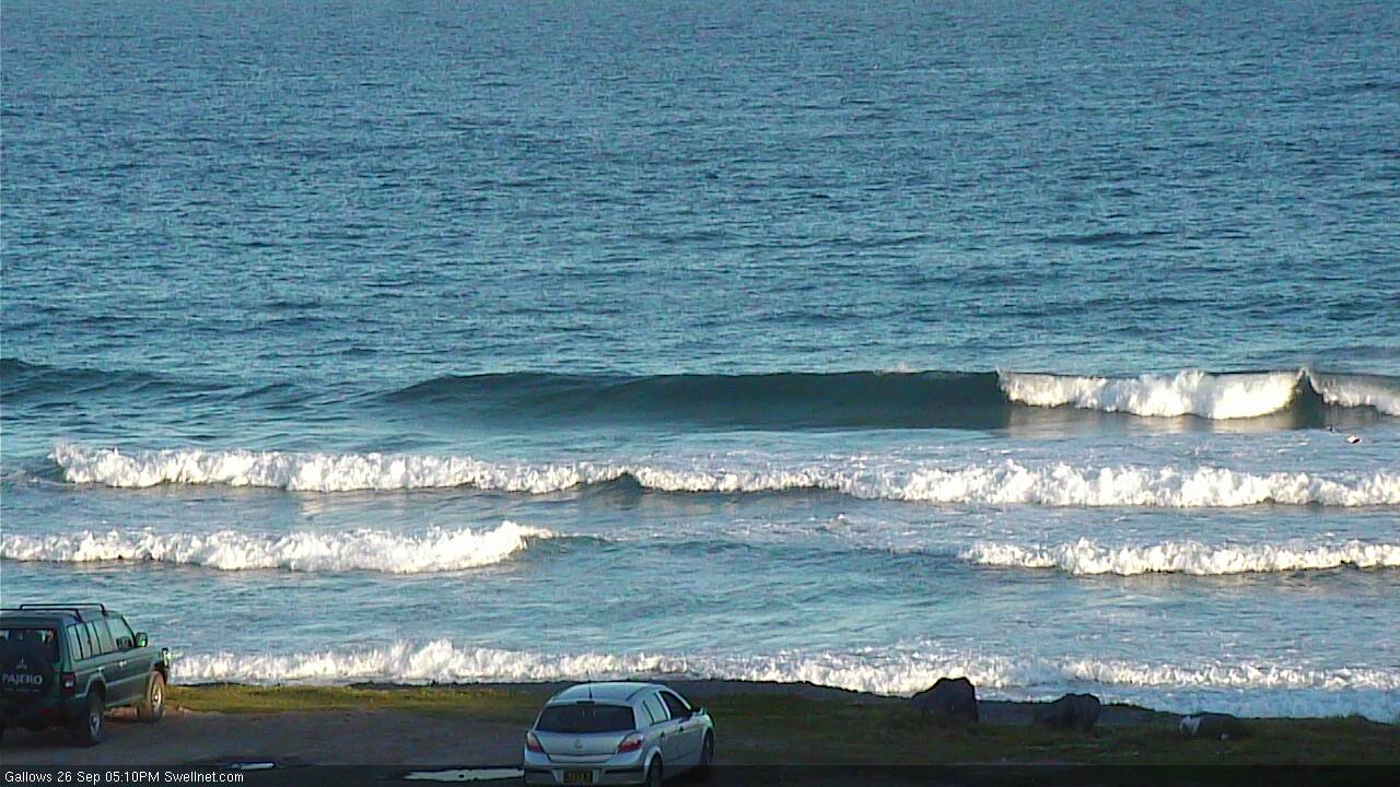
Average new southerly swell across Coffs Harbour this afternoon
This week (Tuesday 27th - Friday 30th)
We’ve got a succession of small south swells for the coming days.
Today’s building southerly swell will probably reach a peak overnight and then trend down into Tuesday. South facing beaches south of Byron will see the most size (inconsistent 2-3ft sets), and conditions are looking generally clean in the lee of a weak trough passing over the coast overnight - early moderate SW winds should tending W’ly then NW as a small front approaches from the south-west. Expect smaller surf at beaches with less southerly exposure.
Two small fetches developing in the south-western Tasman Sea today will then maintain small peaky southerly swells through Wednesday and Thursday; no major size is expected and there'll be long breaks between sets but the bigger waves should hold somewhere between 2ft and 3ft at south swell magnets south of Byron Bay.
Other beaches in Northern NSW not open to the south will however be much smaller, and north of the border we’ll be lucky to see any surf at all over the coming days (south swell magnets may pick up a few stray 1ft sets if we’re lucky).
Wednesday’s conditions look pretty good in Northern NSW with light offshore winds and afternoon sea breezes, but Thursday is another story completely, thanks to an approaching deep mid-latitude low pressure system that’s expected to slam the SA and Vic coasts later Wednesday and Thursday, renewing flooding rains across many regions too.
Strengthening N/NE winds along the NSW coast on Thursday look like they’ll reach gale force strength by the afternoon, which should produce solid surf at exposed NE facing beaches. However due to the northerly fetch alignment, there’ll be a wide range in size across the coast.
NE facing beaches across the Mid North Coast should see 3-5ft sets by the end of the day (smaller earlier), with smaller waves at south facing beaches.
North from Coffs Harbour to the Gold Coast, surf size will be smaller, building to 3ft+ late Thursday afternoon at exposed NE swell magnets - expect a wide variation in size depending on your coast’s alignment to the north. The Sunshine Coast will probably see slightly smaller surf owing to a shorter fetch length.
However Thursday's surface conditions are likely to be heavily wind affected by developing northerly gales. We are looking at a very late W/NW change across Northern NSW, but it’ll probably occur in the early evening, too late to be of any benefit to surfers. I’ll take a closer look at this on Wednesday to see if the models have sped up the change - conditions will improve very quickly once it the wind swings, so even a 3-4pm arrival would bear at least a couple of hours of clean punchy surf.
Friday has some good potential for some good NE windswell across most coasts.
Although the Gold, Sunshine and Tweed Coasts will see comparatively smaller surf (than the Mid North Coast) on Thursday due to their position further ‘upstream’ of the fetch, the evolution of this inland low pressure system across Southern NSW means that SE Qld and Far Northern locations’ swell windows will probably remain active a little longer than their southern cousins.
So, for the Mid North Coast this means that Thursday’s late change will quickly shut off the supply of new swell to the region, and we’ll see much smaller, easing surf into Friday - but we’ll probably still see surf size hold strength across the Gold, Sunshine and Tweed Coasts for the start last day of the working week, with fresh westerly winds keeping conditions nice and clean.
At this stage I’m expecting wave heights to ease throughout the day, so you’ll have to book in a dawn patrol. Most open NE facing beaches from the Gold Coast to the Mid North Coast should manage 2-3ft sets at dawn, before it eases to 1-2ft during the day. Expect smaller surf at south facing beaches, and also the Sunshine Coast may be a smidge smaller than everywhere else.
Let’s see how the models are holding up on Wednesday.
This weekend (Oct 1 - Oct 2)
A strong blocking high east of New Zealand and the lack of a supporting ridge south of the Tasman Sea is expected to focus the approaching mid-latitude low pressure system towards the south-east, so the strongest winds around the low will be out of the western quadrant.
This means we’re unlikely to see a typical strong return southerly swell over the weekend as the broader system moves into the Tasman Sea.
As such, Saturday currently looks like it could be tiny to flat across many coasts as Friday's NE swell is expected to all but disappear.
Westerly gales exiting eastern Bass Strait on Saturday may generate a small, acute south swell for the lower Mid North Coast on Sunday. At this stage I have only low confidence on the chances of any surf from this source, as the fetch is modelled to be straight west in orientation (and ideally we need a touch of south, preferably W/SW or SW).
But, this is the only possible source of new swell for the weekend - if it doesn’t eventuate we’ll be looking at potentially two flat days in a row. Yikes!
Next week (Oct 3 onwards)
There’s nothing major lining up for the longer term at this stage.
A broad, stationary trough is expected to remain just east of New Zealand for much of this week, though its active easterly fetch will remain inside NZ’s swell shadow, so we won’t see any new energy across Australia’s East Coast.
On Friday and Saturday, this region is expected to become reinvigorated by a passing trough, which should strengthen the easterly fetch and also slide it north to a position inside SE Qld’s far eastern swell window. This has some potential for a small easterly swell around Tuesday of next week, though it’s not worth getting too excited about just yet.
Otherwise, it appears possible that a succession of fronts will traverse the lower Tasman Sea mid-week, which could lead to a building south swell mid-late next week, but this is still a long time away so let’s wait and see how the model updates perform later this week.
Comments
Wonder how many takers there'll be over the coming days.
hanging out for friday. been awhile since we had a good ne swell. bring on the lefthanders. yeeew
Hey ben any chance you could cut and paste the mean sea level pressure diagrams in with your reports? I don't want to create more work for you but it would be good to see on the map what you're talking about, kind of a side by side reference. Only if it's not too much bother. thanks
I sometimes do put in a corresponding chart that I may discuss in the notes.. which particular system are you interested in?
Just thinking aloud. Be good to have a pressure map so we can cross reference your notes with the map. I want to learn to be able to read those pressure maps, with the goal of eventually being able to look at one and see if theres going to be a swell. I'm sure that ye olde timers can do it but I think that it would be a good skill to have especially if theres no internet around (highly unlikely but you never know; we might get one of those solar flares that brings down the internet, or a zombie apocalypse? )
Tiny peelers at Snapper, most waves are not even breaking but here's a rogue set (three shot sequence!).