Poor finish to the week; great waves due on Saturday

South-east Queensland and Northern NSW Surf Forecast by Ben Matson (issued Wednesday 31st August)
Best Days: Sat: strong peaky N'ly swell with offshore winds developing throughout the day. Sun: late pulse of S'ly swell across the Mid North Coast. Mon: small clean S'ly swell across Northern NSW.
Recap: Tuesday saw small residual surf across most coasts, however a new S’ly swell pushed across the entire NSW coast today, offering infrequent 3ft+ sets at exposed south facing locations (even a few bigger bombs at select spots). However, beaches not open to the south were much smaller, and SE Qld has remained tiny apart from a minor trade swell across the Sunshine Coast. Freshening N’ly winds have created problems away from protected northern corners.
This week (Thursday 1st - Friday 2nd)
Remember: TODAY is your LAST CHANCE to win a trip for two to the Banyak Islands. More information here.
There’s still nothing special expected for the next few days.
The current swells will steadily ease in size on Thursday and conditions should improve a little across Northern NSW as a front passing south of the region disrupts the existing northerly regime. This may provide some small clean waves across protected northern corners - just the dregs of the current south south swell - but there’s not likely to be much in the way of quality.
Northerly winds will persist across SE Qld on Thursday though a little lighter. Without any notable surf it's not worth getting excited about.
Smaller surf is then expected on Friday morning and winds are expected to ratchet up from the north as trough deepens over inland NSW and tracks to the SE. These winds will generate a local N’ly windswell for Friday afternoon - that may reach 3ft at exposed spots by COB - but there won’t be any quality to it.
The wave models are also showing a very long period (17 second) S’ly swell in the water on Friday afternoon (across Northern NSW), though it’s of dubious origin - an intense but poorly positioned Southern Ocean low a few days ago, well SW of Tasmania. Once again I’d rate this a pretty low chance of producing any notable swell but a few small long lines can’t be ruled out across the Mid North Coast in the afternoon, maybe 1-2ft.
This weekend (Saturday 3rd - Sunday 4th)
On Monday I mentioned that Saturday had some potential for a punch N’ly swell and a window of clean conditions into the afternoon.
The good news is that the models have generally held this line of thinking; if anything the change has been sped up a touch so we should see favourable conditions kick in a little earlier.
Friday night’s northerlies are expected to become quite strong off the coast and we should see some solid waves throughout Saturday, probably peaking into the morning but holding plenty of strength into the afternoon. Exposed north facing beaches will see the most size, and this will become more prevalent as you head south along the Northern NSW Coast, which is aligned slightly east of north to slightly west of south.
This means that the Southern Gold Coast and Far Northern NSW coast down to Byron/Ballina are most exposed to a straight N’ly fetch - as we are expecting - however, they’re positioned closer to the tail end of the fetch than the head - which means a shorter fetch length.
On the other hand, the Mid North Coast is slightly less favourably aligned to the modeled winds, but has the benefits of a longer fetch length.
In reality the two will probably balance each other out.
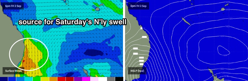
As for size, we’ll probably see anywhere between 3-5ft at NE facing locations on Saturday, with smaller surf at locations not exposed to the NE, and also a little smaller size across the Sunshine Coast due to the short fetch length. However, the key factor will be around the timing of the W/NW tending W’ly wind change. Early morning may in fact reveal a N/NW trend (not bad, but not great, especially following the overnight N'lies) so at this stage it looks like from about lunchtime onwards we’ll see conditions rapidly improve in the wake of the a general westerly flow.
Wave heights may also ease throughout the second half of the day but probably not by too much.
Sunday looks like we’ll be between swells. A deep Tasman Low is expected to form off the Far South Coast of NSW on Saturday, in a historically ordinary location for swell potential for Northern NSW (and very poor for SE Qld). The leading edge of the expected S’ly swell is expected to arrive across the Mid North Coast around mid afternoon on Sunday; we may also see some short range energy originating from a frontal passage around the top of the low too.
At this stage we should see some late sets pushing 3ft at south facing beaches up to about Coffs Harbour but I’m doubtful of any appreciable size north of here just yet. Let’s wait and see how Friday’s models pan out.
Otherwise, Sunday will see very small leftover NE swell from Saturday across remaining beaches, somewhere in the 1-2ft range. Conditions should be pretty good with light winds and sea breezes.
Next week (Monday 5th onwards)
A series of strong fronts wrapping into the weekend's Tasman Low on Sunday will maintain an active W/SW fetch east of Bass Strait, which should ensure plenty of south swell for Northern NSW into Monday, with inconsistent sets in and around the 3ft+ mark at south facing beaches. Expect smaller surf elsewhere.
I can’t see this south swell doing much across SE Qld, apart from a few small waves at extremely reliable south swell magnets.
This swell window will ease in strength into Monday, leading to smaller levels of energy (from this source) into Tuesday, however the Southern Ocean below Tasmania will become very active from Sunday into Monday with an intense series of low pressure systems pushing zonally through the region.
Despite the poor alignment within our window, the enormous width of the active sea state and the longevity of these winds means we’ll see an appreciable amount of swell spread back up along the Southern NSW coast. This should provide very inconsistent 2ft to maybe 2-3ft sets to south facing beaches in Northern NSW on Tuesday afternoon and Wednesday. I’ll recalibrate the numbers in a little more detail in Friday’s notes.
One final front is expected to then track NE back through the lower Tasman Sea later Tuesday and should generate a bigger S’ly swell for the second half of the week. Initially we’ll see some short range energy across Northern NSW from the head of the fetch - around Wednesday - but poor winds may accompany this increase (3-4ft+).
As such, Thursday and Friday are potentially on notice for a stronger S’ly swell somewhere between 4ft and maybe 6ft at south facing beaches in Northern NSW, though SE Qld is expected to see only small surf from this source. I’ll have more details on this in Friday’s update.
Comments
Stay on target.. stay on target...
Use the force Luke.
You can just about lock it in that it will get good on Saturday after the wind change - my wife is at work all day so i'll be on dad duty , guaranteeing it will be pumping for everyone else while I'm at home looking after the kids.
Ballads will be sung about your sacrifice, No-eye-dear. Make no mistake about it.
Hahaha made me laugh!
I shall sacrifice a small woodland creature in your honour no-eye-deer. Thank you for your haikiri for the greater good brother.
Thanks for giving me a giggle roubydouby and waxyfeet, both of you have made me laugh! Hope you score some fun ones come the weekend.
http://www.swellnet.com/reports/forecaster-notes/south-east-queensland-n...
Just over two years since this. Was definitely one of best days of waves I've had around here. Hopefully we get something similar this Saturday.
It won't be anywhere near as good as that was. I'll gladly be proven wrong though haha.
Agreed. I'll still take anything half as good as that though.
Half as good with half the sweep would do.
I hope it aligns, these swells are novelty fun here
Chased it yesterday arvo but far to peaky with a huge wobble thru the underlying long period south swell caused by the Nor/east windswell coming over the top! So frustrating last couple of days, hate to see these long period swells go to waste! Hopefully it'll all come together soon!
Last year Sep 3 had a similar albeit smaller version of the same thing happen. Strong Northerlies all morning then as it moved East the wind swung and lunchtime saw a few hours of decent NE swell / SW wind. What are the odds. No-one out either as it was a Thursday, good times.
https://www.swellnet.com/reports/forecaster-notes/south-east-queensland-...
Conditions are ratshit across the Gold Coast but there are now 2-3ft sets at NE swell magnets like the Superbank.
Current synoptic set up reminds me of spring 2010, where SEQ suffered months of easterlies, rain and shit waves..... Inland troughs around SA/Qld border, continuous highs moving out between 30 and 40s off the nsw coast, massive amounts of moisture feeding in from the tropical and sub tropic pacific......
Looks like a re run.....