Multiple small swell sources to finish the week; long period S'ly swell for Tues/Wed

South-east Queensland and Northern NSW Surf Forecast by Ben Matson (issued Wednesday 24th August)
Best Days: Thurs: fun beachies early morning across SE Qld and Far Northern NSW as the E'ly swell eases and W'ly winds freshen. Fri: chance for an early window (mainly Northern NSW) with a mix of south and east swells. Mon: small south swell across Northern NSW. Tues/Wed: solid, long period S'ly swell.
Recap: Tuesday delivered mainly small E’ly swells across most coasts, however the late afternoon arrival of long period E’ly swell - denoted by a jump in peak swell periods to 15 seconds at most buoys - delivered a late kick in size at exposed beaches to 2-3ft. Unfortunately, northerly winds rendered most breaks bumpy throughout the day. Overnight, a low pressure trough developed off the South-east Queensland coast, initially spreading southerly winds across the Gold Coast around dawn though the very slow moving nature of the trough meant that the southerlies didn’t reach the southern Sunshine Coast until about 3pm. A peaky combo of north-east swell and building long period E’ly swell delivered very good 3ft waves about the Tweed and Gold Coasts, though conditions remained wind affected on the Sunshine Coast until about lunchtime when winds swing W’ly (ahead of the late S’ly). Further south from Byron, gusty S/SE winds maintained below average conditions at many locations south to about Yamba, with light offshore winds reported from Coffs Harbour south to Seal Rocks. Yamba saw a late improvement in conditions as the SE eased and swung light offshore. Wave heights seemed to reach the forecast size of an inconsistent 3-4ft across the Sunny Coast, with 3ft waves about the Gold and Tweed Coasts and smaller surf south from Ballina along the North and Mid North Coasts. Hope you got something worthwhile!
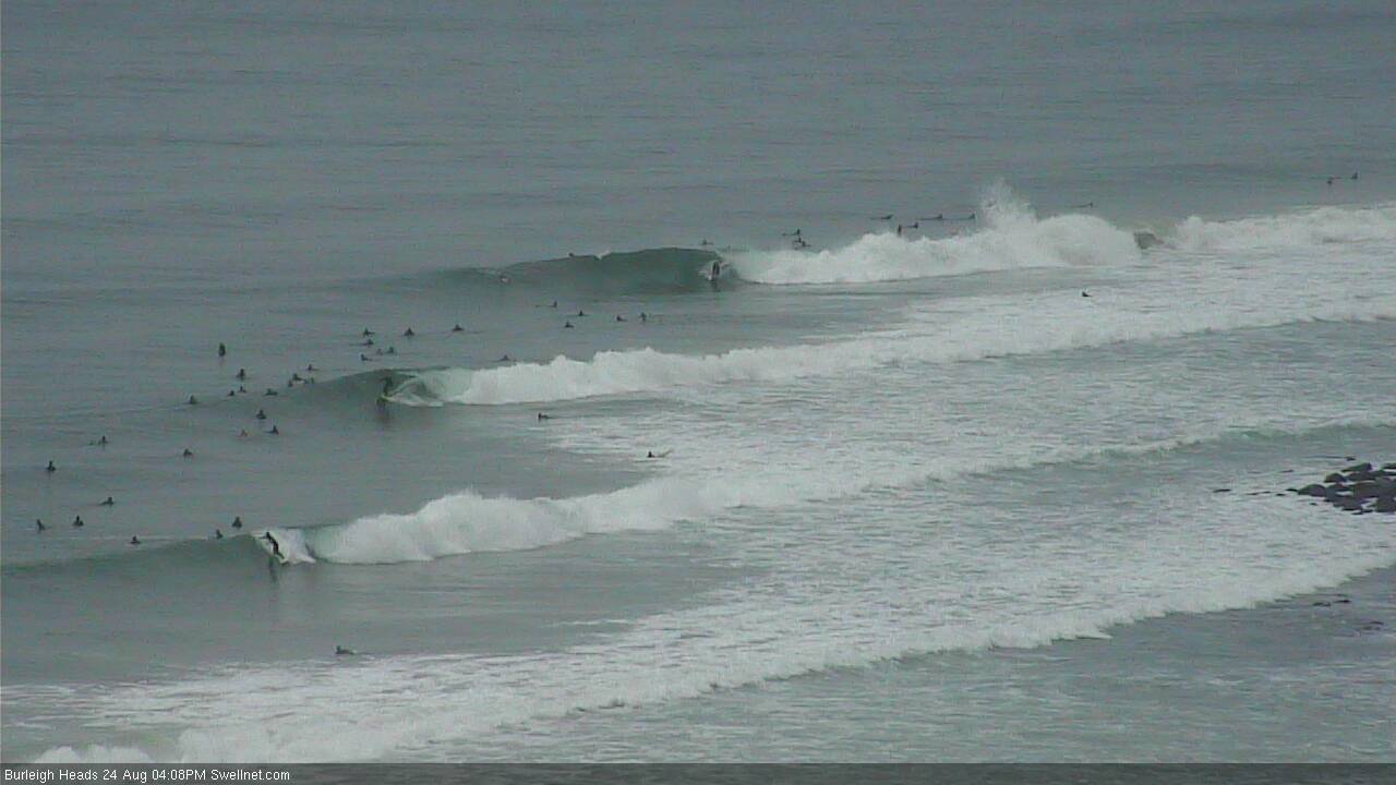
Three on the tree at Burleigh this afternoon
This week (Thursday 25th - Friday 26th)
The synoptics remain complex. But to summarise the existing energy - our long range E’ly swell will slowly ease through Thursday, and the short range NE swell should be all but gone by the morning too.
There are however some new swell sources on the cards for the next few days. Today’s trough/low off the Gold Coast is linked with a second trough/low currently developing off the Hunter coast in Southern NSW. As our trough retreats eastwards, the Hunter trough will follow shortly afterwards but between the two a modest E/SE fetch will strengthen, generating mid-range swell for Northern NSW on Thursday. No major size is expected though it’s worth mentioning as it’ll keep the open beaches active (say 2ft sets, maybe 2-3ft?).
In fact, the Hunter trough/low is expected to rapidly deepen as it tracks east, and models have core winds reaching 50kts through Thursday - albeit on the low’s western flank, aimed up towards Fiji and away from the Australian mainland.
That being said, we should still see a small spread of southerly swell from this part of the low; it’s hard to gauge how much size, but I’m pretty confident it’ll only affect Northern NSW (and not SE Qld). This is expected to push into the Mid North Coast mid afternoon on Thursday, and overnight into the Far Northern NSW (showing for surfers early Friday), before easing during the day.
I’m calling it a low confidence event but wouldn’t be surprised if reliable south swell magnets south of Byron picked up some 3-4ft+ sets.
Otherwise, the models maintain a troughy pattern across the eastern seaboard through Thursday and Friday, under a general SW flow. Although this is not favourably aligned within our swell window, we should see a secondary southerly swell develop across south facing beaches in Northern NSW on Friday, with sets in the 3ft range. Unfortunately, those northern ends picking up the bulk size probably won’t enjoy the fresh W/SW winds accompanying it (tending strong SW across the Mid North Coast), and remaining beaches will be smaller, seeing a combo of swells from the south and east.
Broadly speaking, winds should tend SW across most regions through Friday and maybe S/SW into the afternoon, though most beaches should see a little more west early morning.
As for SE Qld, expect crisp, clean (but very inconsistent) beachbreaks on Thursday morning as freshening westerlies extend around the developing low off the Hunter Coast. Today’s east swell will be slowly abating and set waves will be very inconsistent but there should be occasional 2-3ft sets early morning, easing to 2ft during the day, and 1.5-2ft on Friday. I am doubtful that much of the new swells (mentioned above for the Northern NSW coast) will impact SE Qld beaches, apart from the southerly swell that may glance exposed south swell magnets on Friday - however they will probably become wind affected as early SW winds veer more S'ly during the day.
This weekend (Saturday 27th - Sunday 28th)
Still nothing major expected for the weekend.
And, local winds look dicey on Saturday thanks to a lingering troughy pattern across the coast, which is expected to drive fresh southerly winds across Northern NSW as the trough slides north.
W/SW winds may precede locations ahead of it - i.e. SE Qld - but without any notable swell there won’t be much to capitalise on any favourable windows of opportunity. The east and south swells expected on Friday will be trending down even more into Saturday so only exposed beaches will have any worthwhile size.
Model guidance maintains this trough east of the border later Saturday before weakening Sunday but it’s not expected to develop any major swell generating characteristics. There’s a chance for a small SE swell off the bottom of the trough but I’d be surprised if we saw much more than two or three bumpy feet at open beaches in Northern NSW, and very little in SE Qld.
Let’s take a closer look on Friday to see if things have changed. But, there’s certainly not much to get excited about right now.
Next week (Monday 29th onwards)
On Monday a new small long period southerly swell is expected to provide occasional 2-3ft sets to exposed south swell magnets in Northern NSW. This swell will have been generated by polar low skirting the ice shelf well south of Australia on Thursday and Friday - it’s a very long distance from our coastline, and it’ll be working right on the periphery of our swell window so it’s hard to have confidence in the likely size, but it’s worth mentioning at this early stage.
A much larger, deeper and better aligned low/front is expected to track north-east through the Far Southern Ocean up into the lower Tasman Sea on Sunday, and this will generate a solid pulse of long period S’ly swell for Northern NSW on Tuesday afternoon and Wednesday morning. Early indications suggest core wind speeds of 50kts on a broad active sea state generated by the previous front, which increases the size and period prospects from this system.
At this stage I think we’ll see some large surf from this system across south facing beaches south of Byron Bay, somewhere in the 4-6ft range (though, we are out towards the end of the model run, so let’s give it a few more days). If things pan out as currently forecast, the larger periods should produce much bigger waves at offshore bombies across the region.
The only concern is that this swell may be accompanied by a freshening N/NE breeze across Northern NSW as a broad ridge of high pressure develops in the Tasman Sea.
SE Qld probably won’t see much size from this swell away from south facing beaches, but winds should be much lighter north of Byron so it may be worth sniffing out a swell magnet.
Let’s wait and see how Friday’s models are looking.
Comments
Man, what a tricky day. Wish the complex model runs would ease up a touch!
Appreciate the hard work Ben, looked as though there were some fun waves around the Tweed coast today, I hope you got amongst it yourself!
Thanks mate, had a quick paddle but only got a couple - seemed to be great waves peaking everywhere except where I was!
Sounds like my surf this morning, couldn't seem to find anything really handling the low tide. Shame of it is I know that there would have been waves on a couple of banks I've been surfing lately on the mid-high tide, but alas I was at work.
Looking nice at Alex this AM.
Still some nice waves this morning northern beaches Sunny Coast, a little inconsistent but better then I'd expected. Swell seemed to still have a touch of north in it?
Yeah this east swell was expected to be pretty inconsistent. Unsure about the northerly component, could be some leftover energy from yesterday? Though that should be seen as a seperate swell train rather than any influence on the long range energy.
Depending on where you're surfing, it could also be the long periods reacting to the offshore bathymetry, and 'swinging' back into the coast to impersonate more north in the swell direction than is actually present (therefore, reacting a different way than you're used to seeing at the same beach under short period E'ly swells).
This is a complex part of nearshore wave dynamics - I've wanted to write an article on it for years ("When is a south swell not a south swell?", etc).
This seems to be true here. E / ESE usually look and feel a touch North by the time they're in shore. Would definitely make an interesting read.
Also, got some smoking barrels this morning only a handful out, yew! Proper winter feel... for 1 day this winter haha.
Yep we had a memorable "When is a south swell not a south swell" morning earlier this year. There was zero sweep on the open beachies, it looked straight east, but couldn't have been more from the south
Surprisingly low crowd this morning considering how busy it got yesterday arvo. Smaller but still fun and enough grunt to snap some blokes board in the beachies
Already down to an inconsisent 2ft across SE Qld now. Looks pretty small for tomorrow at this rate.
Still the odd 3ft set at * just now but definitely dropping off from this morning. Tide too full for decent quality on a lot of banks. Beautiful clean offshore day.
Few nuggets about today on the Sunny coast, glad I could capatalise on it before it disappears. Many thanks Ben!
Good to hear fellas.
I'm still drooling over the Burleigh surfcam grab above!
Pumping in Coffs this afternoon!
Arvo sesh was even better than the lunchtime sesh.
Late arvo down here on dropping tide was super fun...but yes that swell is waving goodbye...
Crowdy Head and Coffs buoys picked up a decent spike of south swell this afternoon as expected, from the trough/low departing off the Hunter coast last night. Should be into the Far North Coast for the early session though won't hang around too long. Looks to be on size expectations too (3-4ft+ at south facing beaches south of Byron).
Not very confident that it'll translate well north of the border though.
Felt like 3-4ft mix of sth and east in ballina shire for evening sesh. A bit lully, but.
Really fun beachies just after lunch. Nice shape with a bit of punch and only 2 out.
Clean 3ft sets from the SE across the Tweed this morning. Lovely conditions but still no banks!
Coffs Harbour looking the goods again this morning. Very stoked with this new surfcam!
The Gold Coast is very small, but Burleigh still has surprisingly great shape.
Only small at The Pass but jeez it'd be super fun on a fish.
Still 3-4ft in Coffs! This SE swell off the eastward-tracking Hunter low/trough looks unreal.
Amazing that there's no-one out too.