Moderate S/SE pulse Thursday; extended v.large E/NE swell event from Saturday onwards

South East Queensland and Northern New South Wales Surf Forecast by Ben Matson (issued Monday 30th May)
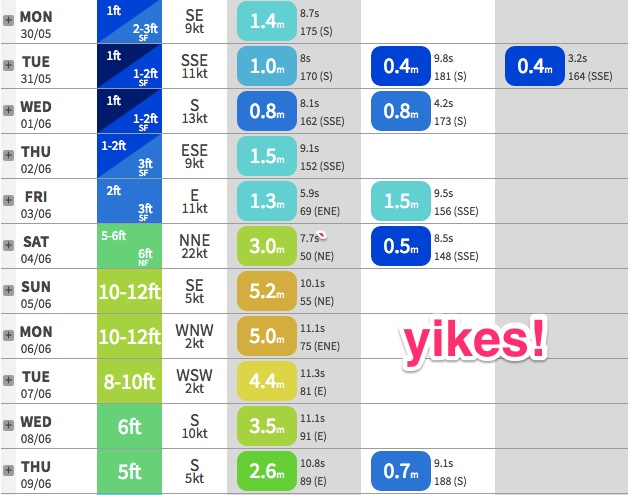
Best Days: Wed: small new S/SE swell building at south facing beaches in Northern NSW. Thurs: moderate S/SE swell filling in across south facing beaches in Northern NSW. Sun/Mon/Tues: large NE tending E/NE swell across all coasts, with light winds developing (following a strong onshore blow Sat).
Recap: The weekend generally played out close to expectations. A new south swell built across Northern NSW throughout the day, reaching 4-5ft+ at south swell magnets across the Mid North Coast during the morning, and then peaking across the Northern Rivers into the afternoon. Unfortunately, the acute southerly swell direction wasn’t favourable for SE Qld, where surf size remained very small. Wave heights then eased back into Sunday, and both days remained favourably clean with generally light variable winds. Today we’ve seen a further reduction in size across the region and a continuation of light winds and smooth surface conditions.
This week (Tuesday 31st May - Friday 3rd June):
No major improvement is expected for Tuesday.
Wave heights will remain tiny across most coasts, and winds should be light early, tending moderate southerly throughout the day. A small pulse of southerly swell is likely to influence Northern NSW’s south facing beaches, thanks to a modest SW fetch positioned off the Southern NSW coast last night and today. But it’s poorly aligned for our region, narrow in width and not terribly strong either - so I doubt we’ll see much more than a lazy 2ft at south swell magnets.
Wednesday has a slightly better pulse of S/SE swell, expected to fill into the Mid North Coast before lunch and the Northern Rivers after lunch, generated by a small S’ly fetch trailing a front tracking through the eastern Tasman Sea today. It’s perked up in the latest model runs; still not ideally aligned for our region but positioned slightly further west within the Tasman, which has boosted the chances for local swell. South facing beaches in Northern NSW should see occasional 2-3ft waves at south facing beaches (keep in mind the late swell arrival across northern locations).
SE Qld is likely to see a small, very late pulse from this source, but most beaches and points will struggle to develop much more than 1ft+; south swell magnets and a handful of outer points may see the odd 2ft+ set if we’re super lucky. But don't count on anything.
A secondary front trailing behind this has also been upgraded in the latest model runs since Friday. It’ll track through a similar part of our swell window, so the swell direction should remain broadly out of the same quadrant, however stronger wind speed, a longer fetch length and duration, and the fact that this fetch will be working on an active sea state all points towards a much more robust S/SE swell pushing through on Thursday (if anything, this swell may be a touch more SE in direction).
Again, an arrival is expected across the Mid North Coast before lunch - wave heights may be undersized at dawn - and it won’t reach the Northern Rivers until after lunch, and SE Qld until mid afternoon. Surf size should reach a solid 3-4ft+ at south swell magnets south of Byron Bay, with smaller 3ft+ surf across the Tweed Coast and 1-2ft across SE Qld (a little bigger at south swell magnets north of the border).
Current expectations are for light to moderate onshore (E’ly) winds across the region though we may see periods of variable winds at times. Again, keep in mind that the further north you are, the later the swell will arrive across your coast. I’ll update these thoughts on Wednesday.
Friday looks super interesting with the early stages of a complex trough expected to develop along the coastal margin. At this stage no real quality is expected but a general increase in stormy short range NE swell (and NE wind) is likely all day, across all coasts.
This weekend (Saturday 4th - Sunday 5th)
How’s those synoptic charts, eh? We haven’t see a progged setup like this for quite some time.
In summary, we’re expecting a large, slow moving high to move slowly eastwards through the Tasman Sea later this week. The fronts traversing the eastern Tasman early in the week (responsible for our Wed, then Thurs S/SE swells) will have exited the region by Thursday, allowing the high to be fully dominant Thursday and Friday.
At the same time, a sharp upper trough is expected to develop across the eastern states, along with a broad surface low. This feature is expected to push close to the coastal margin around Saturday, tightening the pressure gradient between the two surface systems, and strengthening a NE fetch the entire length of the eastern seaboard.
The end result is a building short range NE swell that is expected to reach impressive heights within a short space of time, owing to the close proximity of the fetch to the mainland. In fact, this could end up being one of the largest NE swells seen in many years across the East Coast.
However, these kinds of swells are useless if local conditions don’t play ball. Right now there’s a lot of divergence between the models as to how quickly the trough will push offshore, which will then dictate when, where and how rapidly surface conditions clean up.
At this stage most of Saturday is likely to see strengthening NE winds and steadily building swells - we could see the trough influence local conditions as early as the late afternoon or evening - but it’ll take a while for conditions to clean up. Sunday currently stands the best (earliest) chance at seeing light variable winds.
However, unlike most local swell events where surf heights peak quickly after the local winds reaches a peak, the slow eastward track of this fetch will probably work in our favour as it’ll continue to generate building swells even once local winds become light and variable. As such we may see an extended plateau of large waves through Sunday, possibly even Monday.
This is an unusual occurrence across SE Qld and Northern NSW coasts.
As for size? Being such a rare event, I’m reluctant to commit to a final size range right now (as small variations in the trough’s position could have dramatic effects on wave heights) however our surf models is calling 10-12ft across the Gold Coast on Sunday, and 15-18ft (!) across the Mid North Coast (wave heights will be larger across locations further south, owing to the longer fetch length).
Whilst I think this is somewhat overcooked, I’d be surprised if we didn’t see a peak of at least 8-10ft across exposed SE Qld coasts on Sunday, and 10-12ft across Northern NSW coasts.
At that size, there’s not many locations that offer workable locations, and protected corners can be hard to find. Let’s see how the models are handling the setup on Wednesday.
Next week (Monday 6th onwards)
At this stage the first half of next week will either see an early peak and/or slow easing trend from whatever develops Sunday. The weekend’s synoptic system is a major feature, and the NE infeed is expected to envelp the northern Tasman Sea out all the way back to almost Fijian longitudes, which - if it eventuates - will certainly slow the easing trend considerably.
In short, most of next week could be very sizeable out of the E/NE, even if we do see a gradual drop in size each day. At this stage winds should be light and variable for the most party.
Regardless, there are no other systems on the long term radar right now, so let’s hone in a little closer on this event over the coming days.
Gold Coast forecast model, from Monday
Comments
Holy moley! What a synoptic setup...
everyone should head to d.i like they did for winston
ooooshhh
Nooooo frigin way I have a uni assignment to get through this weekend and early next week! And I just bought a new board and this is probably the last good swell for another 8 months!
mbl88 - I can't blame peeps for trying. If its anything like a couple of years ago when it was nearing 8-10ft DI was the absolute t!ts!
Perfectly timed end to the flat spell, holidays for me!
cunt of a bankbusting thing.
If this system comes to fruition as forecast we can expect a horrendous winter and spring bank conditions as it will be storm bars for as far as the eye can see.
correct. worst case scenario to start winter with. it's a 3-6month rebuild after a system like that.
and the cunt of a thing doesn't even have the decency to form a proper ECL.
Lastest GFS 06z doesn't have it as bad and better winds come Sunday and Monday.
All time peaks for Launceston!
Holy crap you lot are a negative bunch - we have some sicko swell coming and you;re complaining? :D
Hey Ben, you got quoted in the daily rag-Sunshine Coast Daily pitting you against that other website CW.
Snapper should be all time........
Yeah saw that article.
Jeez, the models are moving around a lot - after backing off this event over the weekend, they ramped it right up yesterday (hence the resulting forecaster notes!) but have since eased it back again this morning.
I'd expect more ups and downs over the coming days too.
Whats the swellnet record for comments on a single forecast Ben ?
'Bout 400.
Easing back is good.....might save the banks from utter devastation, which is good coming into Winter/early Spring.
yes, Access G still looks pretty severe but GFS has backed it off and moved the focus further south.
Pity Fiji is in the opposite direction to the fetch
Wellymon your home town is going to be cooking!!! The NZ one I mean!
Haha Fiji....atleast they have until 17th June.
There gonna need it looking at the long range charts - hopefully something picks up
If you have good banks at the moment that you want to keep, then sucks to you.
Been shit banks everywhere down here since forever, whatever happens it couldn't make them worse, and given that it is the complete opposite swell direction for this time of year, could even groom a few banks nicely for later south swells.
:-) Or it could just leave us with differently shit banks.
No doubt everyone will be heading to that other "secret spot" on the sunny coast come the weekend mrmik..speaking of D.I i heard a rumour that while sunshine beach was struggling to nudge head high mid last wk,teewah side was well on its way to 6ft with outstanding conditions minus the 500 people who gambled on winston and lost..been a stack of better days since then also..
DI was epic the Thursday of Winston
Everywhere was good that day
Hope the hoardes in there 4x4's go DI again or c'bar
Anywhere other than where I will be........
When you guys say destroy the banks. Do you mean yhe sand along the points or your beachies? Either way, why is big NE swell the 'bank buster'?
Being from Vicco Nick I was wondering the same thing. I am in Crescent from next Saturday to the following. Will this swell strip the point of sand? And how would Crescent handle a N/E swell like this? Would it bear the full brunt and be 10'+ on the Sunday/Monday or significantly smaller?
all I can say is that you are on the very best part of the coast for a swell like this. good luck chap!
Big NE swells have the ability to gouge the sand off the points and deposit it in offshore storm bars (it's the coast's natural defence mechanism for any large swell event).
The main reason being is that the East Coast has largely adapted to prevailing swells from the south thru' east, which generates a northerly longshore drift and therefore deposits sand (in most cases) evenly around the northern sides of headlands. Hence why the majority of the East Coast's most popular waves are right hand sand bottom point breaks. NE swells hit the points more square-on and the associated current outflows are altered, which transport sand differently.
Big gouging NE swell events can take weeks, sometimes months to repair (see the damage done at the Superbank during those hybrid lows in the mid-2000's). However, in my opinion, the most destructive NE swells are usually storm events from weather systems located very close to the coast.
At this stage I don't quite see that happening this time 'round. We'll certainly see the local beaches readjusted considerably with a good chance for widespread offshore storm bar formation, but I'm not so sure whether it'll tear up the sand along the points. Swell direction will probably be more E/NE than NE too, which is in our favour a little more.
I'm concerned about the beachies. A few in particular which have some epic sand at the moment. Couldn't give a flying fuck about the points, other than if they get trashed that will just force more people to the beachies whcih will be shit considering most beachies will be completely fucked right through winter now.
Any places that crank in big NE swell near you Don? It's not all gloom
Crescent is a true rock bottom point break - it will be fine.
I'm originally from Vic, you'll love it, it's just like home with warm water :-)
What will it be like in this swell? Is that you Harpo?
10-12ft plus N/Ne swell thumping into Crescent ....Phew good luck
The rock off would be lots of fun!
Thanks for the detailed explanation Ben, much appreciated.
Took 2 years for the banks to rebuild after this storm swell event June 2009. Huge swell from the NE/ENE based on a semi-stationary trough line with multiple lows embedded in it.
For a long time it looked like the inshore bathymetry had been permanently altered.
:o