Extended period of great summer waves across most coasts

South East Queensland and Northern New South Wales Surf Forecast by Ben Matson (issued Friday 5th February)
Best Days: Good waves most days albeit windy at times. Pick of the weekend is Sunday morning (smaller Sat as the swell builds but still fun). Easing swells early next week ahead of another round of S/SE tending SE swell peaking Wed/Thurs next week.
Recap: Tiny surf Thursday with developing southerly winds, whilst today has seen rapidly increasing southerly swells across Northern NSW now reaching 4-6ft at south facing beaches. However, surf size is still tiny in SE Qld, a byproduct of the southerly swell direction, initial short swell period and later swell arrival (compared to southern locations). Winds are quite gusty from the southern quadrant in all areas.
This weekend (Feb 6th - 7th)
No major changes to the weekend forecast, though the models have slightly pulled back the consolidation of the Tasman Low - with a slightly narrower fetch of core winds - so I’m going to peg back my expectations just a little.
The overall trend will be up all day Saturday towards a peak on Sunday, and the swell direction will concurrently veer from the S to the S/SE and eventually SE, whilst the wavelength (read: swell period) draws out. This is a good thing.
The implications of this will be most pronounced across SE Qld than anywhere else. The reason being is that southerly swells rarely affect anywhere north of the border - except south swell magnets - unless they’re particularly large and/or strong, of which this event is not. So we desperately need the swell direction to swing east of south for there to be any chance of a rideable wave on our coast.
Saturday morning will start off small across the Gold and Sunshine Coasts, building steadily throughout the day, with Sunday providing the best day of the weekend as the swell reaches a peak in size (generally 3ft, occasionally 3-4ft at outer points and exposed beaches, with smaller surf running down the length of the points).
On Saturday, I think we’ll probably see a slow building trend at the outer points from 1-2ft first thing, up towards 2-3ft+ by the late afternoon. South swell magnets will see bigger, but more wind affected sets.
And if you're at a protected spot in SE Qld like Noosa's inner points, expect tiny conditions for much of Saturday with small inconsistent surf through Sunday. The weekend's swell direction (and relatively low period) really won't be ideal for these locations.
Across SE Qld, winds will remain gusty S/SE throughout Saturday, with isolated pockets of early SW winds, probably confined to the southern Gold Coast, and an easing trend on Sunday expected to allow a broader coverage of the early light SW period, and for a little longer too.
In Northern NSW, there’ll be less evidence of a major trend in the size department this weekend, but for what its worth we should see the swell ‘strengthen’ into Sunday and the direction shift more SE. This should allow a broader coverage of size into the protected spots, which otherwise will start off smaller on Saturday morning. However with fresh accompanying southerly winds they’ll be your best bet all weekend.
Sunday morning still looks like the pick of the weekend, with a peak in size in and around the 6ft mark at semi-exposed points (occasionally bigger at south swell magnets) but much smaller surf at protected locations. For at least the first two or three hours of the day, winds should veer more SW across many locations and this will favour the points nicely. However fresh southerlies will redevelop mid-late morning onwards.
Next week (Feb 8th onwards)
A couple of curveballs in the model runs for next week. But good ones!
It looks like the Tasman Low responsible for the weekend swell will diminish rapidly on Sunday, which would lead to a rapid decrease in surf size through Monday and into Tuesday morning.
However, all of the models have it rebounding south-west back into the central Tasman Sea on Monday, restrengthening a S/SE tending SE fetch in our prime swell window and generating another strong round of swell from later Tuesday through Wednesday and Thursday.
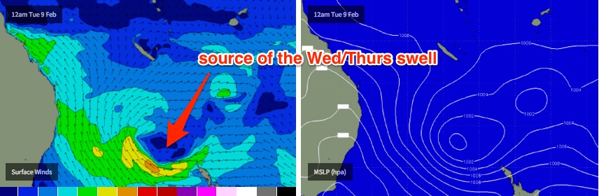
In fact, this is expected to concurrently drive a new ridge through the Coral Sea, which should maintain an extended period of classic summer surfing conditions for the SE Qld and Northern NSW points, under mainly moderate wind strengths from the SW (morning) thru’ S/SE (afternoon).
At this stage we will certainly see the biggest surf south of Byron (6ft+ sets at south facing beaches peaking Wednesday, easing slowly from Thursday), however the outer points in SE Qld should still pick up healthy 3ft+ waves at the height of the activity both Wednesday and Thursday.
We should see a slow building trend on Tuesday afternoon in all locations (with a fair push of southerly winds too) but I’m a little concerned that the initial swell increase will again be quite southerly in direction, capping surf size north of the border.
So, Wednesday and Thursday are the pick of the week at this stage as they’ll have the strongest SE component in the swell direction, and the points should once again be responsible for some fantastic summer waves. I'll revise the size and timing in Monday's notes.
Looking beyond this and a couple of the models are showing a possible tropical depression out near Vanuatu early next week possibly deepening into a tropical cyclone by Wednesday or Thursday, but it’s too far away to have any confidence as to whether this will be beneficial for surf purposes (if it were, we probably won’t see any activity on our shores until at least Friday or Saturday at the earliest). I’ll take a closer look at this on Monday.
Comments
A few bumpy waves showing at D'Bah now. Still a long way to go though.
Sunday Morning it is then!
*Starts thinking of NNSW spots that may be good with a 7:30am high tide*
Tweed Coast was 3ft+ on the way home from the office but all local windswell. Very windy here too. Should be a little bigger by now.
Possible twin systems in the frame next week.
Interesting last year in February there were a twin system also.
Wave height on brisbane buoys seems to be high.
Common swell! Has anyone got a link to view the east coast live buoy readings?
Tweed bouy here:
http://www.qld.gov.au/environment/coasts-waterways/beach/waves-sites/twe...
Thanks Ben
4ft of junky wind affected surf on the Tweed this arvo. Wide mix of swells, lots of short range S windswell but every now and then a solid set with a little more E in it. Hopefully a big improvement tomorrow morning.
Ben, what are your thoughts on this happening at the 180h mark?
http://stormsurf.com/locals/spac.shtml
Still pretty junk-o-rama
Geez that was an underwhelming swell. From Lennox to the border very ordinary
Agreed staitey. Although, we've had such an incredible summer of waves so far, the bar has been set pretty high.
I think the high tides have also killed off broad swathes of this swell (i.e. in the mornings, which most people are out and about trying to get wet), which was a real shame.
I surfed one of the regional points yesterday arvo and it was super fun but this morning - despite only being a little smaller (inco 3ft+ sets rather than inco 4ft+), it was hardly breaking at all. The lines are still there but there's simply too much water over the banks.
Yeah for me my hope outweighed the reality I'd say. Also as mentioned when you have some point sized swell it definitely doesn't help if the its buried under that morning high!
Yeah a couple of this region's point were fairly surfable past couple of days just nothing to write home about. Sand definitely in good places though
yeah, those morning highs killed it ......
but also, that extended period of N'lies prior to the swell seems to have chewed out alot of the banks around here. One in particular, has gone from all-time to almost non-existent.
I am sure other forecasting sites over hyped it.
low looked good on the map but windspeeds were pretty soft and it backed away quite quickly.
now if the extended GFS comes off shitt will really hit the fan. Looks like a Sose redux.
Looking forward to your forecast Ben.