Mixed options, a fun weekend, then building swells next week

South East Queensland and Northern New South Wales Surf Forecast by Ben Matson (issued Wednesday 25th November)
Best Days: Fri: chance for some fun peaky NE windswell at beaches with protection from S'ly winds (mainly in Northern NSW; expect smaller surf in SE Qld). Sat/Sun: small peaky beachies with early light winds. Mon onwards: slowly building E'ly swell right through until next weekend, but with tricky winds.
Recap: There’s been nothing of any interest in SE Qld for the last few days, but Northern NSW picked up a strong long period south swell on Tuesday with 4ft+ sets at south facing beaches, with workable conditions at the semi-exposed points under a southerly flow. This swell eased overnight but a reasonable period of slack winds from dawn provided glassy conditions at exposed south swell magnets with sets of around 3ft, albeit very inconsistent. Fresh northerlies are now up across the region limiting rideable options to the most protected northern corners.
Next week (Thursday 26 - Friday 27th)
Southeast Qld: Thursday will once again be a write off across the Gold and Sunshine Coasts, with no notable swell and fresh northerly winds. A small increase in short range windswell will occur throughout the day but it’s not worth working around.
An approaching trough from the south in the early hours of Friday morning is expected to reach the border around dawn (give or take an hour), before pushing northwards and arriving across the Sunshine Coast mid-late morning. Gusty overnight northerlies should slightly build NE windswells across north-facing beaches for the dawn patrol, but this will ease steadily throughout the day as the responsible fetch is arrested.
We’ll probably see sets of around 2ft from this source, but don’t expect anything amazing in the surf department. However the southern points will clean up quickly once the wind swings, so this should offer a few peaky waves to start the day. The models are suggesting an increase in short range S’ly swell behind the change but I don’t think there’ll be much in it, as the trailing fetch is not particularly strong and weakens slowly throughout Friday.
Most Gold Coast beaches should maintain average 1-2ft surf into the afternoon, reaching 2-3ft at south swell magnets late in the day (though they’ll be blown out with the southerly breeze).
The Sunshine Coast is harder to have confidence in for Friday's surf potential. Firstly, the delayed arrival of the southerly means we’ll be at the mercy of a lingering northerly flow in the morning (probably tending NW). Additionally, with the NE windswell not being especially large, nor the later building S’ly windswell, there may not be enough size on offer to allow for anything worthwhile at the outer points once the wind swings.
The best we can hope for on the Sunny Coast is a small window of light winds ahead of the change - say between 8am and noon - where we may see a few small peaky beach breaks and generally favourable conditions. But I wouldn’t rearrange the diary around this.
Northern NSW: The developing northerly flow on Thursday is expected to become quite strong, and should subsequently generate a decent short range NE windswell in the 3-4ft+ range, especially in the southern regions (wave heights will be smaller as you head north). But finding locations out of the wind picking up this swell will be difficult.
South facing beaches should also see a small residual southerly groundswell in the water on Thursday, but with such tricky winds it may be a little tricky to manage.
On Friday we’ve got a couple of swells expected in the water - continuing small southerly groundswell, a building short range southerly windswell in the wake of a gusty change (due into Port Mac around 9pm Thurs night, reaching Byron just before dawn), plus leftover, rapidly easing NE windswell from Thursday’s blow.
Initially, north facing beaches may see some leftover sets in the 3ft range from the NE but it’ll rapidly drop throughout the day. The southerly groundswell and windswell probably won’t amount to much more than 3ft or so at south facing beaches (with a delayed arrival in the Far North), but only protected southern corners will have workable options due to a moderate/fresh S’ly tending SE winds. It’ll abate during the day though so surface conditions should slowly improve.
The pick of these two days is probably a north facing beach on Friday morning, offering shelter from southerly winds. Hopefully there’ll still be enough leftover NE windswell to make it worthwhile. But as per the SE Qld outlook, I wouldn’t get your hopes up.
This weekend (Saturday 28th - Sunday 29th)
Nothing amazing is expected this weekend, but there’ll be some fun small waves about most coasts.
The swells expected on Friday will mostly have disappeared by Saturday, just some trailing southerly windswell and groundswell at south swell magnets in Northern NSW.
However, a broadening depression just north of Fiji is expected to enhance an impressive trade flow to the south over the coming days, generating an easterly swell that’s expected to be quite a long lasting even through next week. The first signs of east swell are due throughout Saturday, and whilst only small in size, should provide a broad coverage of swell across most coasts.
Much of Saturday will see light winds and sea breezes (E/SE), with inconsistent sets in the 2ft range at exposed beaches. This should nudge up a little throughout Sunday, with set waves between 2ft and maybe 3ft on the more favourable parts of the tide.
We’re also expecting light morning winds on Sunday but the afternoon sea breezes will swing to the northeast, so despite the upwards size trend throughout the day it’ll be worth aiming for an early paddle to capitalise on the cleaner conditions.
More on this in Friday’s update.
Next week (Monday 30th onwards)
This tropical feature near Fiji looks like it’s going to anchor itself in place for quite some time, which, combined with a large high pressure system to the east of New Zealand, should produce a sustained period of easterly swell for the region.
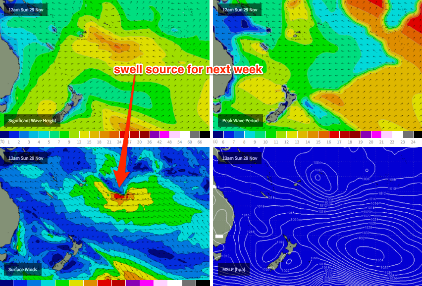
The only downer is that this swell generating system will be located a considerable distance from the mainland, which will impact on consistency. However there are signs towards the ends of the current model runs that an embedded tropical low may may retrograde westward inside the swell window, leading to an enhanced, more consistent groundswell event - perhaps sometime around next weekend.
For now, we’re looking at almost a week of east swell from Monday through into next weekend, with size slowly building from 2-3ft on Monday morning up towards 3-4ft+ through the middle of the week (later Tues/Wed), and possibly as high as 4-5ft+ by the end of next week and the following weekend.
Therefore, with a whole week of waves on the cards you’ll be able to be quite choosy when you surf, in and around the local winds. And this is a good thing, as we’re expecting some form of northerly breeze from Monday thru’ Wednesday, ahead of a southerly change some time around the end of the week.
At this stage it’s hard to have confidence on the strength of the northerly winds - early indications are that Monday will be light and quite workable, but Tuesday and (more likely) Wednesday could be problematic - but let’s take a closer look on Friday.
Comments
I hope the winds play ball! Later next week and the following weekend is looking potentially unreal.
Hey Ben is it looking like this swell should have at least a touch of north in it, especially later in the week when size ramps up a bit?
Yeah maybe a touch (ie more north than south of east) but mainly straight E.
Mmm thanks. Wondering if that 'touch' will be enough for a certain place to have some runners
I am Going to be really pissed if the wind writes this off.
Looks long lived which is good and hopefully a sign of things to come as far as El Nino tropical depression formation in the SPCZ is concerned.
Wednesday onwards looking the goods for the sunny coast......finally
Wow bout time! Finally some sustained East swell! my neck of the woods luv's east swell & southerlies! Bring it on!!!
Chunky backbeaches, lefts, reefs, first 1/2 of the week.... The usual hangouts later in the week..... could get some great variety if you put the effort in....
Not great wind for Monday Tuesday.
If it's light NW early, some spots will be firing, cyl...... I mean this forecast is for north of Fraser to Coffs, right?
Thats close to a best case scenario for the co-ordinates I've punched in.
I could be sunny coastcentric, FR, but Don will yell at me lol .. So I'll just be deliberately vague..
When is the southly change due to come though for Qld?
the spot I'm thinking of will be empty or close to it no matter who says what. sharks will take care of that
s'funny, I surfed it this last time last year in amongst a shiteload of bait balls and it felt sharky as fuck, I actually paddled away from the best peak to go sit with three other blokes .......after almost every wave you'd end up in a bait ball.
Well, bro..... That's asking for it..... Even if it's just a small bull having a munch through the bait ball, it can fuck you up..... Pretty sketchy down here, FR..... Seen a few good waves but no one, just NO ONE around..... Sat on one small rocky point watching these perfect fun little lefts..... Just couldn't bring myself to jump in..... I mean not a freekn soul around for miles.... No phone reception... Felt sorta dirty on myself driving home, but fuck it....
Geezus SD. I'll come surf those places with ya!!!
You'll be right, no sharks down that way.
Well, Don... That halves the odds....... lol...... Hope you organized some time off next week..... I know which way I'd be driving if I was you.... Options you and I have previously discussed a loooong time ago.. ;)
Cheers SD and I appreciate your tight lips on here. Thanks.
Nothing amazing, but a few two foot peaks about exposed spots this morning.
And.. the southerly has just hit the Inner Beacon (central Moreton Bay) - should be up to the southern Sunny Coast shortly, then across the northern Sunny Coast over the coming hour or two.
Craig... Yeah you've said that to me before.... But it's just got that "munchy" jaws music feel to it around here.... When you are with a buddy or a car load, it takes your mind off it.... But like an old golfer with the yips over a putter, all on your lonesome can do your head in..... Heaps different paddling out by yourself for an early amongst suburbia......
Don.. Early tues looks good re' back beaches etc.... And that this stage, wed early looks like a cracker... winds might be light enough and good tide for "super early happy fun time"....... Mid morning - back beaches and "secret spots"..... Your favorite place... Options both ways..... Probably already packed..... Holidays.......
Later in the day really depends on that inland trough, and how much oomph it has sucking in the moisture from the east.... Thurs' trough looks to split and weaken that high, which is common Nov/dec.... Small not so strong ridge kicks in properly on Fri,.... But thurs/ and early fri may be affected by a some east in that southeaster..... As the blind man says, "we'll see".......
Cheers SD. I'm onto it. Only issue I have is fecking work is crazy crazy at the moment and likely to get in the road of this swell!!! Grrrrrr!!!!
If one was to get sick next week what day would be the pick?
I do hope you didn't type this from your work computer!!!
Thursday looking good at the moment, or Friday. I can already feel the early signs of a sore throat. And an aching back.
Oh, hang on, I don't have a boss.... d'oh!
LOL cheers Ben.
my new work hours 7am-3pm have been killing my options lately , I need this swell