Mixed options for northern regions

South East Queensland and Northern New South Wales Surf Forecast by Ben Matson (issued Wednesday 2nd September)
Best Days: Thurs: Mix of easing S'ly swell, new N'ly windswell and small E/SE groundswell with a decent window of freshening offshore winds (best thru' middle of the day). Surf may be undersized in SE Qld though. Fri: solid windy options at semi-exposed points in Northern NSW, brief midday surge across SE Qld (smaller early, and late) with good options at outer points for a few hours around lunch. Sat/Sun: mainly light winds and a small/mod series of south swells in Northern NSW (only small in SE Qld).
Recap: Despite a tricky forecast period, wave heights have generally fallen inline with expectations over the last few days - very small refracted southerly swell across the Gold and Sunshine Coasts, that’s produced solid waves at south facing beaches in Northern NSW, particularly south of Cape Byron, and smaller surf elsewhere. Winds have been favourably light offshore in the mornings with sea breezes creating some bumpiness through the afternoons.
This week (Sep 3 - 4)
The current combo of southerly quadrant swells are easing and will continue to do so through Thursday.
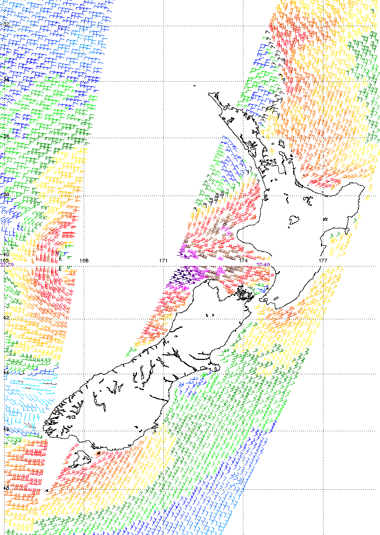
New swell sources for the next twenty four hours are a low quality, short range N’ly windswell (maybe some 2ft+ sets at NE swell magnets, including parts of SE Qld), and a small new pulse of inconsistent E/SE groundswell generated by a small, tight low pressure system that intensified off the West Coast of New Zealand on Tuesday morning (see ASCAT chart below, with core winds of 50kts).
This E/SE swell was aimed mainly towards southern NSW, so wave heights will taper off with increasing northerly latitude - maybe 2-3ft across the Mid North Coast, with 2ft+ surf across the North Coast (I don’t think it’ll do much north of the border, maybe 1-2ft). Note: this is bigger than our surf model is estimating - it often struggles with easterly swells originating from these kinds of systems.
So, that’s three potential swell sources all in store for Thursday, and the combination of them all could produce some tasty results at the right kinds of beaches. But, local winds are the wild card for how the surf will pan out.
A developing low off the NSW coast will freshen N’ly winds overnight, but they’re modelled to swing NW early morning Thursday then W'ly by lunchtime, ahead of an evening SW change. As soon as winds swings to the NW, the swell source for the N’ly windswell will shut off, and typically we’ll see wave heights start to ease some 3-5 hours later. So, expect this swell to taper off throughout the afternoon.
Confidence isn’t high on just when the winds will swing, but the middle of the day probably has the most benefit for surfers as we’ll probably see the best combo of size and conditions (earlier may see some leftover northerly wobble, later may see smaller wave heights).
The low developing off the coast is then expected to push a gale force S’ly change along the Mid North Coast early Friday morning (a few hours before dawn), reaching the border mid-morning. This will generate a short lived south swell that’ll be very wind affected at exposed spots; set waves should push into the 4-6ft range ay south facing beaches in Northern NSW. But semi-exposed points will offer the only (smaller) rideable waves due to the winds.
SE Qld will see a swell increase from this source but I’m hesitant to get too excited as the fetch simply doesn’t last very long in the swell window.
If anything, this suggests a brief window where the surf spikes but then rapidly falls away - the timing of this is probably sometime around lunch or early afternoon. So, expect small leftover conditions early morning, with building S’ly swell through mid-late morning towards an early afternoon peak (2ft+ most Gold/Sunshine Coast beaches, 3ft+ outer points, and bigger but wind affected south swell magnets).
Chances are though that this peak will last just two or three hours before falling away through the latter part of the day.
This weekend (Sep 5 - 6)
Friday’s southerly swell will ease rapidly into the weekend. In fact I’m not expecting much leftover swell north of the border at all, only south swell magnets in Northern NSW will see any notable size first up Saturday - perhaps some 3ft sets at south facing beaches, with much smaller surf elsewhere. Exposed beaches in SE Qld may onlty be a foot or two tops, and smaller everywhere else.
However we will see some small new southerly swell across the Northern NSW region, originating from a series of moderate polar fronts tracking well south of the Tasman Sea tonight and tomorrow. This should keep south facing beaches in the 2-3ft range through Saturday afternoon. Unfortunately, I don’t think we’ll see much translation north of the border. So expect small waves to persist in SE Qld.
A second south swell is due to push through on Sunday (morning Mid North, afternoon Far North). Sunday, which will originate from the merger between a polar front and a mid-latitude low, just S/SE of Tasmania during Friday. This should provide the same, if not a smidge more size than Saturday’s south swell however both have been downgraded since Monday’s notes. Expect smaller waves away from south facing beaches, and SE Qld will probably dip out again with just small weak swells occupying most beaches.
As for local winds, most models maintain a dominant ridge of high pressure across the region which suggests we’ll see light variable winds and afternoon sea breezes both days. But I’ll have more info on this in Friday’s update.
Next week (Sep 7 onwards)
More of the same for next week. Most computer model guidance suggests a cut off low will push across Tasmania early in the week, leading to a renewed short range south swell early-mid week. But, specifics are a little hazy at this early stage so we need a few more days to firm things up. Stay tuned to Friday’s notes for more information.
Comments
Wow amazing detail,nothing else like this around.Hope Your getting just rewards for your efforts.Cheers.What a great season for the Sth swell!!
Hi Themalben
Your reports have been bang on for the Northern NSW region. Thanks for taking the time to provide these detailed reports free of charge. No other website compares to your accuracy
Cheers
Geebuzz, the Tweed Waverider bouy must be feeling like its been on a rollercoaster overnight. How's the swell direct graph?
https://www.qld.gov.au/environment/coasts-waterways/beach/waves-sites/tw...
Yes, Ben, great reports... Once you figure out the influence of the Caldera on local conditions you'll be onto the best days yourself. Can't believe you hadn't cleared your schedule for yesterday morning!
Thanks for the nice words guys, it's been a tricky couple of weeks but I'm pretty stoked overall. It's amazing to see just how variation there is across the region under a south swell - thumping at some spots and tiny at others.
WN - the schedule's pretty tight with other stuff at the moment, so surfing's not a priority. Knew there'd be good waves somewhere but 'clearing the schedule' isn't any option right now.
Looks like the NE windswell is building across the Goldy nicely (see surfcam images below) - once the wind swings I reckon there'll be great waves through the middle of the day, might even push a little higher than I estimated, at some exposed beaches.
Hey Ben, yeah mate, understand, I missed a heap last year due to other commitments. I'm just rubbing it in for ya, cause I know first hand how much it hurts!.
It was 'one of those days' yesterday. :)
Stop rubbing it in! Ha.
Junky 2ft on the North end of the GC, Hopefully the change cleans it up and the size doesn't disappear.
Winds have been westerly for the last hour or so.. game on across the beaches!
How's these NE lines sweeping into D'Bah?
(Short range) lines for days!
blech.
Doesn't look too shabby around the corner....
Dbah can be so fun in a NE swell, but tweed has a few rare gems
Just pumped here, like a mini version of the big NE swell last August sweep included. Cracking little 2ft+ offshore barrels every 100metres. Blink and you missed it though, lasted an hour at best, good fun!
Still wind affected out the front of the (new) Swellnet office. Good 3ft on the sets though.
Well that was sick fun. Northern Beaches, Sunny Coast
Unreal Ben. Give yourself a big pat on the back. Just had two hours of crazy short period peaks on the Sunny coast. Sweep was like a conveyor belt hope it hasn't flattened out banks.
Yeh massive change from this morning, 3ft sets where i was dropped back to around 2ft after a couple hours, sweep was brutal but peaks along the stretch some better then others.
Been on the road since 3am and haven't had much time to analyse the developing low, but confidence has dropped that we'll see much size in SE Qld from it this afternoon. I'm currently on the Mid North Coast where exposed south facing beaches are a chunky 4-5ft or so (at quick glance) and building, but the latest model runs have pushed the low eastwards faster than previously expected, with less focus up along the NSW coast. So, the more usual SE Qld result is likely later today (i.e. very little size away from the swell magnets).
Hey Ben, can you give us an idea of what was so different about yesterdays NE swell. I' ve lived here a long time but yesterdays the northlie wasn't overly strong and was only blowing for a short amount of time, yet the surf was up to 4 ft at Dbah. Usually we have a heaps stronger northlie with the surf half the size at most. Been a goofy footer would love to see more days like this.
Bump this. Without the forecast I wouldn't have even bothered checking the surf, cheers Ben
Just got down at the desk. VH - I'll have a look over the weekend.
Byron buoy is showing a nice J-curve (Hsig 3m, Hmax 5.58m) and there's a few 1-2ft waves showing at Snapper, tho' its very slow. Still can't see much happening north of the border from this south swell.
Looks a good 4-6ft on the Coffs surfcam too, albeit quite junky.
Gallows would be blown out in this wind. Not much swell hitting the other side yet either but lines of swell showing at about the same point the wind starts to affect it. If only there was a spot exposed to south swell and nicely protected from the south winds ;)
Not much happening here yet ...
Any luck getting a surf on the way down Ben? Or, was the swell not getting into those few spots you had time to check?
Nah no surfing today. Didn't have much time, and the exposed spots I saw were wind affected and the protected spots were too small.
Bummer. You do that coast run, or head for the highway?