Plenty of south swell for Northern NSW, remaining small in SE Qld

South East Queensland and Northern New South Wales Surf Forecast by Ben Matson (issued Monday 31st August)
Best Days: Most days should have good waves in Northern NSW, Tues the biggest. SE Qld expected to remain small for the entire forecast priod.
Recap: A strong S’ly swell pushed across Northern NSW on Saturday, and early offshore winds swung to just a light to moderate sea breeze in the afternoon, so conditions were workable at many locations after lunch. A small, distant easterly trade swell provided just-rideable conditions across SE Qld. On Sunday the south swell eased back in size and early offshore winds swung fresh southerly late morning, wiping out the open beaches and rendering the only surfable locations to protected southern corners. SE Qld remained small. Today we’ve seen a new S’ly swell build across the coast though wave heights are slightly under expectations (which is kinda ironic, as yesterday and today pushed slightly higher than forecast across Southern NSW, from the same swell event). Surf size remains very small across SE Qld.
This week (Sep 1 - 4)
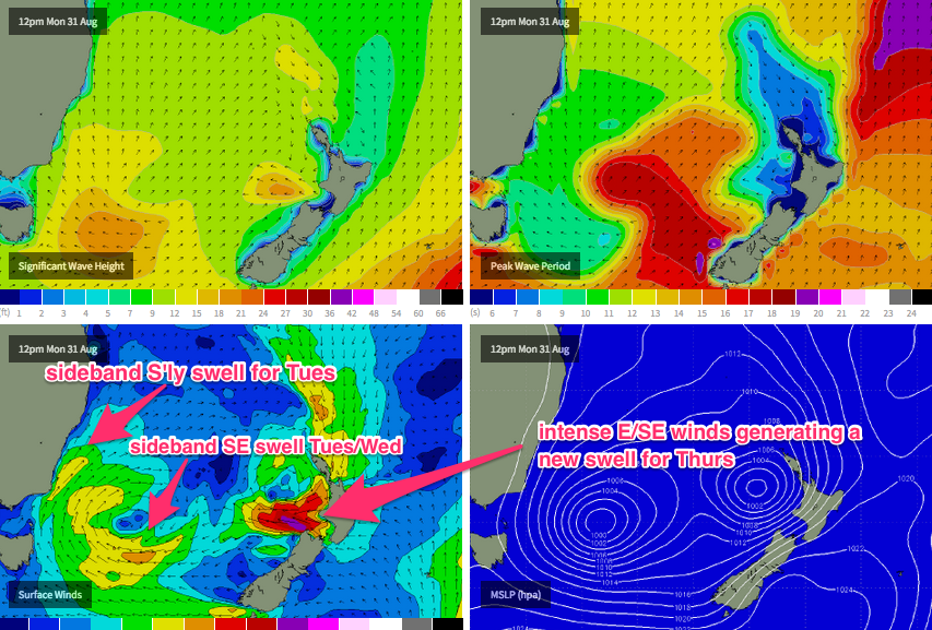
We’ve got a complex synoptic chart at the moment. The current south swell pushing across Northern NSW was generated by a strong front that wrapped around a broad, multi-centered low pressure system over the weekend, which had previously occupied the Tasman Sea since late last week (and is related to the ECL that delivered a strong SE swell to Southern NSW).
Over the coming days, we need to consider how much residual swell will maintain from the existing southerly event (being supplemented by a strong SW fetch off the South Coast), plus several sources of new swell - some SE swell on Tuesday and Wednesday across Northern NSW, from the parent low in the Far Southern Tasman Sea, plus a brief pulse of E/SE groundswell on Thursday from a temporarily intense secondary low that’s currently developing west of Cook Strait (the body of water separating New Zealand’s North and South Islands). See the chart below.
But the long and short of this pattern is that SE Qld will remain very small for much of the outlook period. All swell sources are located in unfavourable parts of its swell window and therefore any energy we do see will be a significantly diluted version of what’ll be on offer south of Cape Byron.
So, let’s look at Northern NSW first. Today’s south swell will ease into Tuesday, but we’ll see new sideband energy from the SW fetch off the South Coast plus some sideband SE swell from the low in the Southern Tasman Sea. This should generate 4-5ft+ sets at south facing beaches through both Tuesday and early Wednesday, with an easing trend into Wednesday afternoon. Beaches not completely open to the south will be considerably smaller due to the strong southerly component in the swell direction.
As for local conditions, they’re looking pretty good - a light synoptic pattern on Tuesday should create early offshores in most regions and light to moderate afternoon sea breezes. Wednesday morning will see similarly light winds again but the afternoon is on target for a freshening NE flow as a new synoptic feature starts to take shape across the coastal margin. So surf early on Wednesday for the biggest and best waves.
In SE Qld, I’m not expecting much of this southerly swell to make it north of the border. Aside from reliable south swell magnets, most beaches are likely to languish in the 1ft to very occasionally 2ft range, mainly consisting of small distant east swell. Winds are looking comparable to the North Coast (early offshore the pick). So keep your expectations low for surf in this neck of the woods, and aim for a south swell magnet where we may see very infrequent 3ft sets.
Thursday looks very tricky. First of all, we’ll have a new E/SE swell in the water, which I referred to in Friday’s notes as being ‘sneaky’. The reason for this is that the synoptic chart is quite busy at the moment, and at a quick glance, the primary low in the Southern Tasman Sea is the focus of everyone’s attention. However a small low west of Cook Strait is expected to become supercharged this evening from an indeed of tropical moisture from the north, resulting in 45-50kt winds for a brief period into the early hours of Tuesday morning - and it's easy for this to slip under the radar (especially as the swell models don't seem to be picking it up very well).
This should set up a brief pulse of E/SE swell that’s due to the arrive in the early hours of Thursday morning, however as it’ll be aimed mainly towards Central/Southern NSW, I don’t think we’ll see as much size in the northern regions - maybe an inconsistent 2-3ft across the Mid North Coast, with smaller set waves across the North Coast around 2ft, and very little action in SE Qld.
Compounding the issue on Thursday will be the local winds, as an upper trough crosses the coast and a new surface low forms off the Southern NSW coast. We’re likely to see a small level of N’ly windswell on Thursday from the developing airstream overnight - size is as yet unsure - and the general wind trend will be for some form of N'ly wind early morning to swing NW, then W’ly ahead of a S’ly change overnight Thursday.
So, there's certainly a good chance for a window of fun waves at some point on Thursday - including the chance for some peaky N'ly windswell at exposed north facing locations in SE Qld and Far Northern NSW - but you’re much more likely to score good surf from the E/SE swell, at locations with increasing southerly latitude.
This new surface low off the South Coast is expected to be a Tasman Low, and not an ECL (mainly due to its rapid eastward track), but as yet its timing is unclear - and this has a bearing on when and where we’ll see a swell increase across the North Coast. However, at this stage it looks like being a windy, ragged affair to finish the working week - Friday may see some low quality surf building to between 4ft and 6ft at south swell magnets (based on current model guidance) but it’ll be much smaller elsewhere due to the likely low swell period and acute southerly direction.
I’m doubtful that this swell will produce any meaningful waves in SE Qld either, mainly due to the anticipated storm track to the east - but let’s see how this plays out in future model run updates.
This weekend (Sep 5 - 6)
Friday’s new S’ly swell is expected to ease through Saturday, but it’ll be supplemented by a new long range S’ly swell originating from a polar front moving through the Southern Ocean (and up into the Tasman Sea) later this week. Based on the latest wind forecasts we should see a peak somewhere in the 4-5ft range at south facing beaches.
This swell is expected to build later Saturday and peak early Sunday before easing during the afternoon, however we are at risk of a southerly airstream both days (early mornings should be OK though). As such, current thinking is that semi-exposed points in Northern NSW will see the biggest and best waves this weekend, with exposed stretches likely to be blown out.
As for SE Qld, with prevailing southerly swell expected both days, we can anticipate small waves to continue throughout this period. The best chance for a wave will be to identify periods of light winds (at the moment, Saturday morning looks like a good contender) as this will open up options across exposed south facing stretches. However I’ll have more details on this in Wednesday’s notes.
Comments
Small peelers at the Superbank.. where is everyone?
Haven't seen it that quite before we're are the 100 people hiding.
went into NNSW yesterday Ben, would have to say your forecast was spot-on, thanks for that!
Unreal Yocal - glad you scored!
That WOTD today, could have been taken near here this morning. Where were ya Ben?
Mornings are flat out for me at the moment (actually, who am I kidding.. they're always flat out!) - and Wednesday is our busiest day. Couldn't get away for an early paddle unfortunately.
Still a few peelers round the corner at Snapper.
This straight south swell has been awful for any spot that isn't exposed to it. The whole coastline north of Cape Byron has been 1-2ft all week. Even up at Tweed-Kingscliff it was 2ft max this morning. At least the conditions were nice.
Don't wanna go into too much detail, but it's been bigger that 2ft along the Tweed Coast for the last few days. Sure, only at selected spots, and also not quite as big as exposed beaches south of Byron, but there's been plenty of unreal waves on the right tide.
Agree. Very fun
great waves all week. white shark cleared the water yesterday afternoon at the Point.
solid 6ft bombs coming through every now and then yesterday in exposed spots in NNSW
This morning was cranking.
Noticeably more punch than yesterday morning.
Don't know if I'd call it solid 6ft Yokes, that's a bit of an overcall if you ask me.
3-4 with the odd bigger one.
Again, the report was farcical giving it a 4/10. Fuck, if you can't give clean overhead point surf a pass mark you're in the wrong game.
reaching double overhead where I was on the bombs
No specifics but what region Yokes?
too hard to answer that one! but everywhere else I saw was as forecast - between 3-5ft on open beaches and smaller in the bays
I'd be keeping that place up your sleeve yocal. Went for a drive a few hours into northern NSW yesterday and got inconsistent 5ft max. Great conditions up until lunch but long waits between bombs.
Rarely a day over 2ft here since May. Time to move.
whereabouts Sprout?
South end Sunny Coast mate. Terrible swell this winter and not many banks around for what comes through. Unfortunately means larger than normal crowds at my local too. Maybe I just need a holiday haha.
Drive North Sprout,You'd be suprized.
Drive North Sprout,You'd be suprized.
Ehhhh, south end, sprout?..... The airport thru to A bay is the go, mate...
When its flat sure... But most of the good setups are south of the airport.
I'll happily disagree with you there, 9999.... ;) But we'll both keep our lips sealed.... I get in trouble from donny when I start naming spots lol
Love ya work SD!!!
On a lid.
Your area has a better crowd factor tho.
Edit: I'm a sticker I took most to be >50%.
Due to lack off surf on the gc and proble some laziness only surf twice in 2 months. so un surf fit and leave for bail in 14 days.
Jump in the pool and swim 1km at least 2-3 times per week for the next two weeks and you'll never look back in Indo afterwards. Worked for me.
This is good advice, to add to that simulate 5 duck dives by touching the bottom of the pool every 10m explode off the bottom and swim the next 10 flat out touch the bottom repeat. 2 weeks you can make some good gains, take the fins out of a board put it on your bed and practice 10 pop ups 2 x a day you'll be ready when you get off that plane hope ya get some good ones.
Cheers Thanks for the great advice.
Hahahaha... Yep, the big mother of sand stops the south swell for the southern sunny coast, but... Know where to look, and influence of tidal movement, and you'll find gems on the southern end. Tidal movement influence important around there I found... If ya working normal hours without flexibility, ya fucked...
And, one of the few truly offshore locations when its howling from the north...
Don't really need flexibility just knowledge. Bad tides at 1 spot mean good ones at another for most conditions.