Small weekend of waves, lots of activity next week

South East Queensland and Northern New South Wales Surf Forecast by Ben Matson (issued Friday 31st July)
Best Days: Sat: small clean waves at south swell magnets in Northern NSW in the morning. Not much in SE Qld. Sun PM onwards (for 4-5 days): small pulsey trade swell for SE Qld. Won't have much size but should be surfable, just. Tues/Wed: fun south swell in Northern NSW. Late Thurs/Fri/Sat: large S'ly swell in Northern NSW, with small clean waves across the SE Qld outer points.
Recap: Thursday delivered easing southerly swell across Northern NSW and exposed south swell magnets north of the border. Today, the early/mid-week south swell had all but gone but a small signal of new long period south swell - with peak swell periods around 18-19 seconds - graced the coast and provided occasional 2ft+ sets at south facing beaches. Elsewhere, the Sunshine Coast has seen a small level of trade swell with occasional 2ft sets at open beaches, and smaller surf across the Gold Coast.
This weekend (August 1 - 2)
Today's long period south swell performed marginally better than expected across most of the NSW coast. And based on what we saw across Southern NSW late this afternoon, we should see it continue into Northern NSW on Saturday morning.
At this stage south swell magnets across Northern NSW should maintain occasional early 2ft+ sets however an easing trend is expected throughout the day (earlier in the south than in the north), and it’ll probably be all gone by Sunday. So make the most of Saturday - particularly the morning - as we’ll see light NW winds tending N/NW then maybe N’ly during the afternoon and begin to freshen. They’ll maintain strength through Sunday from the N/NW, so surfing options will be limited across Northern NSW with tiny leftover south swell on offer.
As for trade swell potential further north - we’re not expecting a great deal on Saturday, probably similar to what we’ve seen for the last few days - tiny surf on the Gold Coast (1-1.5ft), with a few weak 1-2ft waves across the Sunshine Coast.
However, the weekend will be a transition point between sources of trade swell, and Sunday should see a slight improvement. Our most recent swell was generated from a ridge through the Coral Sea, but this is weakening. However, an unseasonable tropical system near the Solomon Islands is tracking south, and tightening the pressure gradient between it an a large high north of New Zealand. As such there’s a modest band of easterly winds expected to ebb and flow in our swell window - just the northern periphery, E/SE of New Caledonia - for the next few days. It’s located further away from the mainland than is ideal, but it should generate a small E/NE swell for the next week or so, beginning some time on Sunday.
It’s likely to be a slow start, but we should see a slightly better spread of swell from this source across the region, with most Sunny Coast beaches seeing occasional 2ft+ sets by the afternoon, with slightly smaller surf on the Gold Coast and then further down the Far Northern NSW coast (I can’t see this swell influencing anywhere south of Yamba).
The main problem on Sunday will be the threat of northerly winds. It’s likely that they’ll remain NW, which is fine for most open beaches but just keep this in mind when choosing a location. The sets will also be very, very inconsistent owing to the distant swell source.
Next week (August 3 - 7)
We’ve got a complex period of surf ahead next week. For the most part though, we should see a small undercurrent of trade swell across SE Qld, anywhere from an inconsistent 2ft+ on the Sunny Coast, with slightly smaller surf as you track south along the coast. NW winds are due Monday ahead of a S’ly change early Tuesday that’ll veer back to the western quadrant for the rest of the week.
Now, the real dynamics in the forecast period originate within our south swell window. The incredible series of Southern Ocean fronts I’ve been discussing all week is still on track, but it’s proving to be a little elusive to pin down the exact swell potential for the NSW coast.
The main problem is that the primary storm track is mainly west of Tasmania, so most of the initial swell generating fetch is being steered up into Vicco and SA. Successive model runs have shunted it east, then west, and also pushed back the final phase of the LWT, which makes it hard to get a grip on exactly when we’ll see a solid swell event in our waters.
Therefore, because of all of these model changes, I’m not totally confident on the outlook from this source for next week. I’ll update in the comments below over the weekend if confidence does increase but for now take all of the info below with a pinch of salt.
At this stage the first front is expected to push into our southern swell window - just east of Tasmania - on Monday morning. Whilst we may see a minor increase in refracted southerly energy during the day (from a fetch trailing the initial front, say 1-1.5ft south swell magnets across the Mid North Coast), the bulk of this swell won’t arrive across Northern NSW until Tuesday. The most likely scenario here seems to be somewhere in the 3-4ft+ range across south facing beaches. Winds are expected to veer W/SW on Tuesday, following a S’ly change on Monday (midday across the Mid North Coast, late arvo in the Far North), so conditions should be reasonably good.
The swell window is expected to then temporarily shut off during Tuesday as another strong front rears up from the SW, which means we’ll see declining wave heights through Wednesday afternoon and early Thursday. Conditions will be clean under a westerly airstream though.
Another major low/front combo will then drop off the Southern NSW coast early Thursday morning. The southerly swell associated with this event is expected to peak overnight Thursday or early Friday, and should reach 6-8ft at south facing beaches in Northern NSW - don't expect much action before lunchtime though, and the Far North may not see a decent kick until mid-late afternoon. However there’ll be a lot of wind associated with it thanks to the close passage of the front near the coast. So, only semi-exposed points will have anything worthwhile.
As for SE Qld, I don’t think the initial push of southerly swell will have much of an impact north of the border, but the late Thursday (or more likely) Friday swell should produce some good waves across the semi-exposed points along the Gold and Sunshine Coasts, perhaps in the 3ft range. South facing beaches will be a couple of feet bigger - but probably wind affected - however most beaches will be a little smaller due to the swell direction.
Anyway, at this stage it’s too early to pin down the timing/size specifics of this large southerly swell, as we’re also expecting followup systems for the weekend that could add additional energy at some point later Friday too. But the general consensus is that it’ll be big out of the south, and probably with a bit of wind on it too. Also, keep in mind that for the entire duration of this southerly swell, wave heights will be considerably smaller at beaches not open to the south. More on this in Monday’s update.
Next weekend and beyond (August 8 onwards)
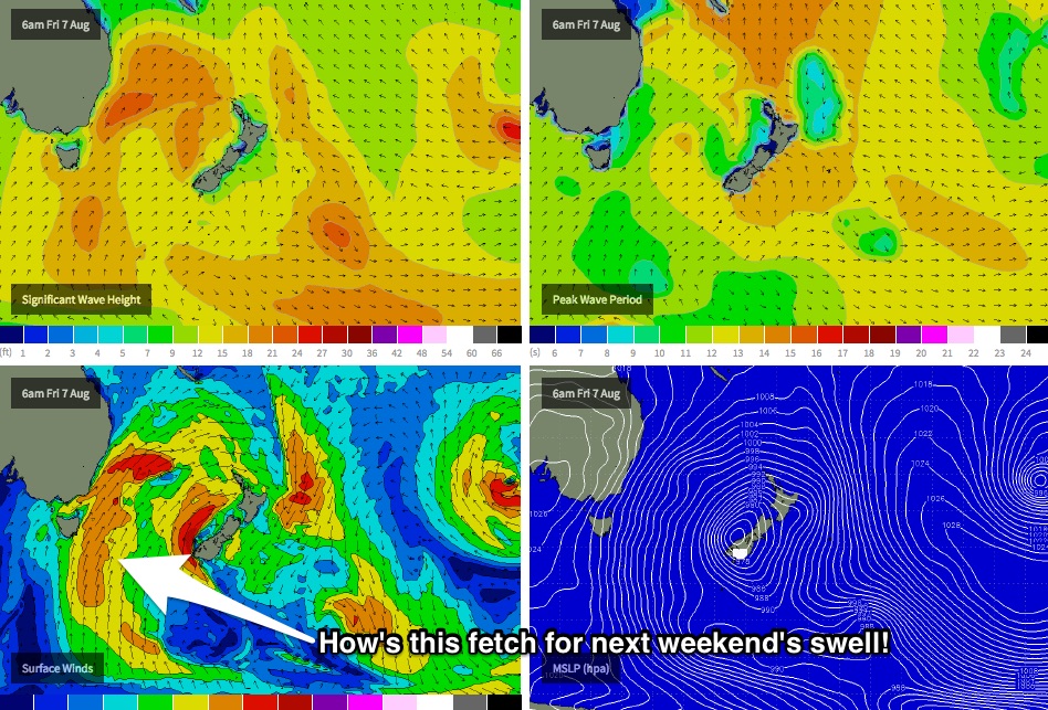
Based on current model guidance, the strong southerly swell expected later next week should hold into Saturday before easing throughout Sunday. In fact this potentially may deliver the best swell of the entire sequence, as it'll be sourced from polar latitude thanks to the LWT finally pushing east of Tasmania, allowing for a very long southerly fetch to develop within our swell window (see chart below). But, winds will probably remain from the southern quadrant (maybe SW) which means the best waves will be at sheltered locations. More on this in Monday’s update.
Comments
Beautiful morning in Byron bay with one lone surfer enjoying the micro peelers
With the shark attacks lately I couldn't do it........
I don't think there's anything to worry about at the Pass when it's one foot. Old mate's surfing in waist deep water, and is probably five metres from dry sand.
Thats a funny call Ben...!
As a good mate got stalked right onto the beach in Port Hedland whilst waist fishing, by a Bronzie,
Literally was 6 ft from the water line and the 4M bronzie jumped onto the beach snapping at his heels......!
Yeah heard all kinds of stories about GWs launching themselves up on to rock shelves, couple of my mates many years ago had this happen to them at Portland. Scary stuff!
Bit o' fog around Noosa this morning.
Shame about the trade swell, hasn't really come up as expected. Was a small, flukey source anyway.
She's a real low tide this arvo! Lots of rocks showing at Moffs.
Some one Tell me there is a decent swell coming soon.