Fun E'ly swell Tues; complex system late week with strong swells; excellent weekend ahead

South East Queensland and Northern New South Wales Surf Forecast by Ben Matson (issued Monday 27th April)
Best Days: Tues: More E'ly swell, good winds for the beachies early morning, then semi-exposed points as winds veer S'ly. Fri: large storm swell building across the region, but winds may switch offshore in SE Qld during the day. Sat/Sun: strong but easing E'ly swell with freshening W'ly winds - another excellent weekend for the beachies (although they may be overpowered in some NSW locations on Saturday).
Recap: Fantastic waves across all coasts over the weekend, ranging from 3-4ft in SE Qld to 3ft across the Mid North Coast, all under glorious sunny skies and offshore westerly winds. Wave heights temporarily dipped this morning but have perked up again this afternoon with yet another pulse of groundswell from the same system, albeit during its passage towards the swell shadow of New Zealand’s North Island. As such this energy is mainly favouring SE Qld with the biggest waves. Winds have also swung southerly thanks to a change that pushed across southern NSW yesterday afternoon, and there’s a corresponding mid-range south swell building across exposed parts of Northern NSW.
This week (Apr 28 - May 1)
More of the same for Tuesday. The current E’ly swell will continue to dominate the northern reaches of SE Qld, with inconsistent 3-4ft surf across the Sunshine Coast and slightly smaller surf with increasing southerly latitude.
Also in the mix across Northern NSW on Tuesday will be a topup of southerly swell, from the same system that generated today’s new energy. A large high in the Bight is directing fresh to strong southerly winds through the Tasman Sea, and will continue to pump out south swell for the next few days - but it will only favour exposed south facing beaches in Northern NSW (the swell direction and low periods won’t favour refraction into SE Qld). Tuesday should see 3ft to occasionally 4ft waves from this source at south swell magnets, with smaller surf at protected spots.
Local winds are expected to be fresh southerly across most regions for much of Tuesday, however we should see local periods of SW winds in the morning, especially in SE Qld. Once the wind swings you’ll be restricted to semi-exposed points.
The east swell should hold into early Wednesday morning before easing during the day. However the south swell will be slowly easing in size, so surfers south of Ballina will need to make the most of the early session to maximise the size. Freshening SE winds are also expected throughout the day but we should see light winds early.
Thursday looks very dynamic on the weather front, but ultimately poor in the surf department. Both the previous south and east swells will be on the way out. And winds look very ordinary: a coastal trough is expected to form off the Northern NSW/SE Qld region, possibly with an East Coast Low eventuating (although we’re not entirely sure about this yet). As this occurs, easterly winds will strengthen in most areas - mainly north of Ballina - and this will build a short range E/NE swell about the coast.
Right now the models aren’t in much agreement about how this synoptic pattern will evolve, but there’s a strong likelihood that the coastal trough (or ECL) will gradually shift southwards over the coming day(s).
It’s important to note that locations south of the trough’s axis will experience strong E’ly winds, however locations to the north will see a westerly outflow. So the timing of the trough’s southward track is important as it’ll dictate when conditions will eventually improve. And under this kind of pattern, the Sunshine Coast would be the first surf region to see the ‘improving’ conditions, then the Gold Coast, and so on.
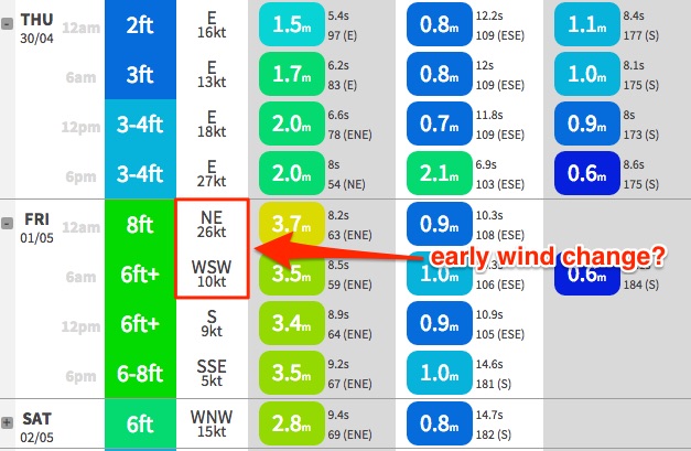
At this stage, Friday looks like starting off very wet, wild and wooly in most regions with gale force E/NE winds and a large storm swell in the 6-8ft range. However, there is every chance that we could see a rapid about-face throughout the day - particularly in SE Qld and Far Northern NSW - with winds veering southerly then south-westerly (see chart below for the Gold Coast, which suggests the onshores will abate early morning).
If this happens there could be some excellent and sizeable (although roguey) waves about the coast. For now, let’s keep a close eye on the mode guidance over the coming days - there probably won’t be any great deal of certainty in the specifics until a day or so before the event.
This weekend (May 2 - 3)
Friday’s large storm swell will ease rapidly into Saturday but with rapidly improving conditions there should be some great waves across the region. In fact the Mid North Coast will probably see large waves all day as it’ll be the last region (within these forecast notes) to see the effects of the trough. Conversely, it’ll also be the last location to see an improvement in conditions.
Right now, we’re probably looking at 4-5ft+ surf across SE Qld early Saturday, easing to 3-4ft during the day, but wave heights should be bigger south of the border (maybe 6-8ft). With freshening W’ly winds around the northern flank of the low it’s currently shaping up to be another weekend of excellent beach breaks. Surf size will drop through Sunday but winds should remain from the western quadrant. Let’s take a closer look on Wednesday.
Next week (May 4 onwards)
Despite the trough (or low) moving out of our swell window through the weekend and into early next week, we’re likely to see a broad NE infeed from the South Pacific at the same time, which will continue to supply small to moderate E’ly swells through the first half of next week, somewhere either side of about 3ft.
In fact, with an approaching Long Wave Trough slowly tracking towards our region early next week, we’ll probably see the trades restrengthen E/SE of New Caledonia, which should maintain plenty of energy from the easy through the rest of the week (model guidance has an increase later Thursday thru’ Friday and Saturday into the 3-5ft range in SE Qld… let’s wait and see!). 'Till Wednesday...
Comments
"Wave heights temporarily dipped this morning but have perked up again this afternoon with yet another pulse of groundswell from the same system, albeit during its passage towards the swell shadow of New Zealand’s North Island."
Mooloolaba buoy not showing any real signs of an increase this arvo? Both in Hsig or swell period?
Going on surfcam obs. Moffats this arvo looked as big as I've seen it in the last four days.
So care to explain the lack of supporting data on the mooloolaba buoy?
Not sure Don. Only know what I saw with my eyes. However Tmax has been strong all day, and Tz actually increased this afternoon despite the presence of a local onshore flow. Buoy data doesn't always tell the full story.
There was no sign of any E swell here as on dark.
nothing.
it was pure S.
As shown on the Byron Buoy.
That's certainly what my interp of the wave buoys is also Steve.
.
Don, ages ago, you said you were not overly convinced by Qld data, and normally refer to Byron.... Have the qld buoys been improved in any way?
I'm convinced your swells in the water this morning. Wave buoys including Byron clearly showed a new swell arriving overnight from the E/SE.
Hey Ben,
I'm thinking about flying up to Noosa for the (extended) weekend, you think it´s worth the trip or should I opt for the Goldy instead?
Cheers
i bodysurfed snappr to greenie all morning, east with south swell coming in at keyhole.
some great fun rides with some 3 foot plus sets easy. heaps of waves but boardriders have no respect for bodysurfers at all. pity, like to see most of them survive the swell in the water rather than being on a craft. such is life, my enjoyment level not affected.
It's here. Good calling dog. Local surf reporter has completely missed it in this mornings report.
What's the size down your way Steve?
there is a lot going on wams in the next week bit confusing
Cheers, steve, Don.... Steve, I'm pleasantly surprised with the size down your way..... Whilst we're having a love in (lol), you also nailed a decent call with your "2 swells in the water" quite a while back..... Byron buoy totally backs that up....
Don, a certain cross country fave of yours would be all time today... But would've had to been there this morning..... I'm sure someone scored it.....
5 days aye dog... Back to that old chestnut :p
Before you shuffle off to be with Shorris in Gimpland, what were the 2 fisherman tales you wanted to test?
S swells bending westward towards low latts and....?
S swells bending westward towards low latts and....?.... And...... none of your business...... ;)
The same theory I put to captain craig crankypants is about to occur in another ocean..... Same scenario...... In fact, it's giving the east coast nice swell right now..... So you know which system, right? Watch what happens BEHIND it..... An ecl, and a far off low create a prime area........ Within 7 days , what is happening in that region? A big sw swell..... That's what... A low is currently sitting in the W.A region I mapped.... And what's happening BEHIND it?..... A big sw swell... That's what...
A sub tropical low is dropping below Madagascar 1/5/15.... And what's sweeping in BEHIND IT? Wouldn't be a sw swell swell, would it?????
I know you know that between Long Wave Trough nodes there are ridges where it's prime for the development of these weak troughs and stationary lows.
The large swell for WA and Indo and then Southern Africa is all about the LWT, not the other way around. Chicken and egg not really, LWT nodes and ridges are the steerers.
That may very well be true.... But what I am saying is the low that is causing this east swell formed near the tropics above a very strong high.... I dont' think the tropical development of it or the current tropical low off W.A is directly caused by the areas between the nodes...
All I am saying is that as a untrained old boaty, if it was 1980, before the net, whenever I saw a tropical or sub tropical low head sse into the southern storm belt ( even a decayed system like below), I'd be looking sw for the next week, expecting a sw swell to be taken into consideration re my navigation.....
Sw swell for tahiti....
Decayed low at 158 -30.... Now watch what happens behind it......
Whether there's a link, no link, if it's the LWT's doing, the tropical lows doing, or pure fluke, whenever I see a tropical low in late autumn heading towards the se, I will look behind it, down towards the antarctic...... Well I would if I lived in Fiji, or Tahiti, or Margaret river.....
I think the south-east movement is linked to the apporaching arm of the LWT and its sterring effect on systems back down towards the poles.
Much like its affect on polar fronts behind it, strengthening and projecting them north-east on a track similar to the shape of the LWT.
That's very possible, Craig.... And it seems like clockwork.... Note world map below madagascar next week.... I'd assume it to be an autumn and maybe early spring thing ( spring ecl's), during the "clash of summer and winter"..... Whatever way one look at it, it is worth putting in the "old timers swell call book"......
Now onto my next study..... Air moisture and density..... Does it make a difference? ;)
I spoke you could say the LWT supports the S flanks of the mid lat H, which cradled the troppo low. Still, something needs to happen in the tropics too doesn't it?
That low wasn't there 2 days ago. And now the Models are loving it. Predicting 10 foot for Bali. Jeez big call.
3-4ft with the odd bigger one. was a bit weird, not quite as good as it promised to be.
22/4 FR - "If it comes in combo with another swell then it's happy A-frame."
Well I didn't think Byron would fair that well due to NZ, steve....... I stated north of straddie would be the go... But is anywhere down your way getting those "happy a frames" you were hoping for re " swells? Or are those spots a bit wind affected today ?
yeah, just a bit too much S'ly wind muck around.
was a few early but it wasn't quite on.
Although Sydney buoy isn' showing much I reckon some of the swell was getting in down here as well. North Steyne was picking up strong but very inconsistent 3ft sets out of the east.
Hard to see it refracting all the way over the top of New Zealand and down to us, but with today expected to be the peak of this event, I'm sure it's from this source.
It really was a beautiful looking fetch "on paper'..... So....... An ECL... Then days of east swell.... A quick south swell for NNSW..... Another possible ECL on the way.. And then a chance of a moderate easterly trade swell after that...... Having a good run, fellas......
it's been a feast.
The wind was great all weekend even main beach was clean.
I just hope this next low doesn't feck the banks. We don't need it coming into late Autumn/Winter.
Too right Don.
Great banks everywhere IMO.
Best summer/autumn up here for consistency that I can remember for a long time.
Lucky pricks......... ;)
Still a few sets standing up at D'Bah right on dark.
shhhhh!
Hey Sheepie,like the way your thinking mate throwing a few ideas around and questioning how things are percieved cause theres always room for improvement.I like the way you and Craig are exchanging ideas.Good work cause im also learning.
WOW check out the BOM forcast for Se Qld ,looks like they taking swell forecasts a little more seriously,bout time