Weekend is the pick of the forecast period

South East Queensland and Northern New South Wales Surf Forecast by Ben Matson (issued Friday 27th February)
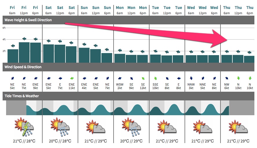
Best Days: Sat/Sun: early morning across the beachies.
Recap: Fun mid-range E’ly trade swell on Thursday (2-3ft sets at most beaches), increasing a little more today with the addition of an inconsistent long range E’ly groundswell (3ft, occ 4ft sets at exposed spots). Light winds early, tending onshore during the days and freshening.
This weekend (Feb 28 - Mar 1)
Overall, we’re looking at an easing trend this weekend. Today’s combo of E’ly swells are expected to slowly ease, so Saturday morning will have the most size.
A modest fetch of SE winds through the southern Coral Sea will strengthen this afternoon and then ease through the weekend, but winds are expected to be under 20kts so we probably won’t see much more than a couple of feet concurrently from this new source (and only at exposed beaches north of Byron).
So, the combined energy should generally hover in the 3ft range early Saturday (maybe a few stray 3-4ft sets in SE Qld early morning) before easing to 2-3ft during the day. Expect slightly smaller waves through Sunday, and overall locations south of Yamba will see smaller wave heights than to the north.
Local winds will be mainly light to moderate from the E/NE (more N/NE along the Mid North Coast), however a decent period of light variable winds (i.e. probably offshore) should persist through until about mid-morning. So, the mornings will certainly be the best time to aim for a surf.
Next week (Mar 2 onwards)
The trades are expected to remain active north of New Zealand through the weekend and next week, however strengths are still pegged to be only 20kts or less. Given that the bulk fetch will mainly be positioned in our mid-to-far swell window, this unfortunately means that there’ll be a significant loss of size as the energy propagates towards the mainland.
So, with Sunday’s surf easing a little more through into Monday we’re looking at an extended period of small beach break surf for most of next week - mainly slow, weak and inconsisent energy from the eastern quadrant, just a couple of feet on the more favourable parts of the tide.
There are however a couple of regions to keep a close eye on for Monday’s updated notes:
1. Southerly change advancing along the NSW coast on Monday. It probably won’t generate much swell for Northern NSW (and definitely not SE Qld) but it may trigger a building ridge across the Qld coast that could supply some short range energy to the region, plus a gusty SE breeze (around Tuesday). Right now the models aren’t very confident on this scenario but there’s a chance for an upgrade over the coming days.
2. A strong series of deep Southern Ocean lows/fronts through the southern Tasman Sea from late Wednesday onwards. These are likely to generate plenty of S’ly swell for Northern NSW, but as we well all know, such patterns are very poorly aligned for SE Qld so we won’t see much size north of the border. At this stage Friday will herald an initial windswell increase (4-5ft sets at south facing beaches in Northern NSW) with a similar sized groundswell for next weekend. SE Qld will be much smaller from this source though, probably just a foot or two at best away from the swell magnets.
Otherwise, despite a period of inactivity appearing across our eastern swell window, there is still some potential that we’ll see some developments north and north-east of New Zealand mid-week, resulting in an easterly swell for next weekend. It’s too early to have any confidence on the likely size right now so I’ll take a closer look on Monday.
Comments
Shift the WSL comp to Margs.. Ha ha
Has been an excellent Feburary for the sunny coast !
How do you spell layday?
D-Bah?
I don't think changing the break is going to change much no swell = lay day hope some thing pops up on the charts
I think dbah will be more than contestable tomorrow.
They will b loathe to go to Dbah because all the commercial merchandising and sponsor displays are set up at Snapper.
The days of this comp being mobile are over.
When is the Outsider going to take his guns to town ?
?
I know very little about surf prediction but snapper turns to a dogs breakfast with any North in the wind
I think he's warming up in the sheds now Blowin
As I said last week, medium long term looks poor... So they should slam dunk as many heats as possible today and maybe tomorrow....
A new round of easterly trade swell should start around the 8th or 9th.... Also signs of a TD around the same time up in the solomon region.... Probably not a big enough comp' window to get any swell from that.... Hopefully huey speeds up it's development....
will b interesting to see viewer numbers if swell stays small. this will give good indication of the star pulling power/extravaganza as compared to a surfing spectacle of waves and waveriding. Hope people enjoy it, but i much prefer watching what happened last weekend.
Gday, Davo... yeah well pundits spoilt for choice at the mo' - world cup, 4 codes of footy, car racing.. Only die hards will be viewing I reckon... BTW, just had rod rockets niece and mum stay for a few days... Showed em' round southern tassie.. Was really great....
Anyway, hope that map above speeds up. Drop us a line... Cheers bro.....
sounds like good time u all had. i guess we get to see high class surfing in ordinary waves here a lot, so a comp with lots of tea bagging is boring as. gee last fri and especially sunday mid morning was smokin, inside greeny mid tide shacking big time.
spent most of my time trying to run over those sucker paddlers on my jet ski at kirra and then had a sip session with warren young and the clubbies as we laughed at the whinging bastards coughing on my petrol fumes as we let the native dog off his leash for a bit of water patrol. serves the bastards right for trespassing on our secret spot.
Who won that cricket game today...?
you nearly messed it up big fella, a starc reminder not too get too carried away. hope u r well and got some barrels lately.
can the black caps play away from home though?
I know the long term models throw up some fantastic scenarios,but hows the prognosis on SN wams for 13th March onwards.Thats the most incredible storm I've ever seen!!
Pure fantasy,still We can dream!
It really is looking diabolical re' quicky, till at least the 8th.....
I'm really digging SN's WAMS at the moment, yesterdays model never started from the 10th to the 15th, Todays does... is that a sign of model consistency? really looking forward to watching this develop if SN's models are on track;)
A very similar TC pattern up here since Ola, Maria could this be called 'Na Ua' maybe 'Na loka'
1034hPa east of the Chatham's, could be a Ben Hur of swell if this lines up...?
Very interesting!
I know its a long way out at this stage and the computers aren't big enough to make accurate models this far in advance, but hey it looks exciting IMO
Any thoughts from experienced weather people out there!
Way way way too far out to have any reliability or confidence associated with it.
Variance between models is staggering also. Access G going for WA cyclone first.
Uuuummmm.
Yeah for sure DW, was just asking an experienced thought. o;)
Was just a speculation of the last few months herewith, similar weather patterns have occurred ie TC's.
We really don't know eh:)
I'm gonna bet something big as its about time, The time is soon..